- Dawson, New Mexico
-
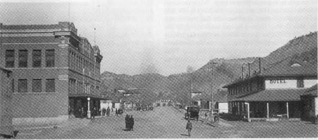
Dawson — Ghost town — Main Street Dawson, 1916 Location within the state of New Mexico
 Dawson
Coordinates: 36°39′51″N 104°46′29″W / 36.66417°N 104.77472°WCoordinates: 36°39′51″N 104°46′29″W / 36.66417°N 104.77472°W Country United States State New Mexico County Colfax Time zone Mountain (MST) (UTC-7) - Summer (DST) MDT (UTC-6) ZIP codes FIPS code GNIS feature ID Dawson is a ghost town in Colfax County, New Mexico, United States and was the site of two separate coal mining disasters in 1913 and 1923. Dawson is located about 17 miles northeast of Cimarron, New Mexico. Dawson was a coal mining company town founded in 1901 when rancher John Barkley Dawson sold his coal-rich land in northern New Mexico to the Dawson Fuel Company.[1] The Dawson Railway was built connecting the town to Tucumcari, New Mexico. The mines were productive, and by 1905 the town boasted a population of nearly 2,000, later reaching around 9,000.
Contents
History
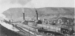 The Coke Ovens in Dawson, 1920
In 1906, the mines were purchased by the Phelps Dodge Corporation. The corporation needed to attract workers to the remote location, so they built homes for the miners, along with numerous other facilities including a hospital, department store, swimming pool, movie theater, and a golf course. With these amenities, Phelps Dodge was able to maintain a stable employment rate despite the inherent dangers of mining and the isolation of northern New Mexico. Many of the miners were recent immigrants.
In total, the Dawson coal operations had ten mines, numbered 1 – 10 in the immediate vicinity of Dawson. The mines are generally referred to as "Stag Canyon #", a reference to the operating company, but they are also often referred to as "Dawson Mine #", in reference to their locale. Different web pages which use GNIS data have the Dawson Mine No. 5 as being located eight miles north of the other mines. In looking at other source documents found in Google Books, this appears to be an error. The actual Dawson Mine No. 5 was located along the Vermejo River, near the town of Lauretta.
Several of these mines were connected to the coal processing and loading facilities in Dawson by means of an electric powered narrow gauge (36 inch gauge) railroad. This railroad was apparently 6,600 feet in length, running along Rail Canyon from the entries of Mines 1, 2, 3, 4 and 6. Mines 5 and 7 also connected to this line through underground connections to the other mines, but they also had their own tipples. Cars would be loaded inside the mines, taken outside and then transported in trains of cars to the facilities in Dawson proper. This line served the No 1 & 2 Tipple, located in Rail Canyon.
Mines 8, 9 and 10 are located to the SW of the town of Dawson, and early research indicates that they had their own mine tipple for coal cleaning and loading into standard gauge railroad cars for delivery to customers. These three mines also had an electric powered railroad inside the mines which led to their own tipple, but they apparently were not connected to the other mines.
The coal was cleaned of non-combustible debris and sorted into general sizes for different uses. In addition to the coal processing facilities, there also were coking ovens which processed the coal, transforming it into coke which was used for metal processing by Phelps Dodge at other facilities. The coking ovens produced carbon monoxide gas, which was captured and then burned to create steam for generating electricity for mine machinery and electric lighting, both in the mines and in the towns around the mines.
The Dawson Railway was purchased by Phelps Dodge at the same time and made part of its El Paso and Southwestern Railroad system. The EP&SW was later purchased by the Southern Pacific Railroad, which also purchased long term contracts for the coal production from Dawson. The SP used steam locomotives which were mostly fueled by oil, but the operating division located at Tucumcari utilized coal fueled steam engines, the only group of such locomotives on their roster.
Disasters
On October 22, 1913, Dawson suffered its first major disaster. Stag Canyon Mine No. 2 was shaken by an explosion that was felt two miles away in the town proper. Relief teams rushed in from surrounding communities, but of the 286 men who arrived to work in the Stag Canyon mine that morning, only 23 survived. Two rescuers died during the rescue effort. It was later determined that the explosion was caused by a dynamite charge set off while the mine was in general operation, igniting coal dust in the mine. This was in violation of mining safety laws.
The other mines remained productive after the disaster in Mine No. 2. Then, on February 8, 1923, Stag Canyon Mine No. 1 suffered an explosion. A mine car derailed, igniting coal dust in the mine. 123 men were killed in this explosion, many of them children of the men who died in 1913.
Shutdown
Dawson did not become a ghost town until 1950, when the Phelps Dodge Corporation shut down the mines. At closure, Mine 6 was the largest producer, and several other mines had been previously closed out because of declining demand. The closures were also due in large part to the completion of the twenty five year coal contract with the Southern Pacific Railroad. The entire town was sold or razed, with some of the miners' houses moved to other locations. The tall smoke stacks of the coking ovens were eventually demolished in the early 2000s because they represented a liability to the current owner of the property.
The Southern Pacific branch to Tucumcari was lifted at about the same time, but was later rebuilt by the Santa Fe Railroad, continuing up the canyon to the York Canyon mines. These mines were initially operated by Kaiser Steel, with their output being transported to their steel mill at Fontana, California. The York Canyon mine was operated by several different companies, finally closing in the early 2000s.
Present day
The town of Dawson is now largely gone, with only a few buildings remaining.[2] The only significant remaining landmark in Dawson is the cemetery, which is on the National Register of Historic Places.[3] The cemetery is filled with iron crosses marking the graves of many miners who died in the mines. Other markers show the burial locations of other residents of Dawson. Dawson can be reached by proceeding approximately 12 miles east of Cimarron, NM (on Route 64), then turning north at the sign, for another 5 miles to the site of the Dawson cemetery.
Notes
- ^ "NEW MEXICO LEGENDS: The Ghosts of Dawson". LegendsofAmerica.com. September 2008. http://www.legendsofamerica.com/HC-Dawson1.html. Retrieved August 28, 2009.
- ^ "Dawson, NM". GhostTownGallery.com. http://www.ghosttowngallery.com/htme/dawson.htm. Retrieved 2009-08-28.
- ^ "National Register of Historical Places – NEW MEXICO (NM), Colfax County". National Park Service, US Department of the Interior. http://www.nationalregisterofhistoricplaces.com/nm/Colfax/state.html. Retrieved 2009-08-28.
Further reading
- Sherman, James E. and Sherman, Barbara H. (1980) "Dawson" Ghost Towns and Mining Camps of New Mexico (2nd edition) University of Oklahoma Press, Norman, Oklahoma, pp. 62–69, ISBN 0-8061-1106-2
- Wilson, Delphine Dawson (1997) John Barkley Dawson: Pioneer, Cattleman, Rancher (2nd edition) Wilson, no location specified, OCLC 43944875
External links
Municipalities and communities of Colfax County, New Mexico County seat: Raton City 
Town Villages Angel Fire | Cimarron | Eagle Nest | Maxwell
Unincorporated
communitiesMiami | Rayado | Sunny Side | Ute Park
Ghost towns Dawson | Elizabethtown | Pittsburg
Categories:- History of Colfax County, New Mexico
- Ghost towns in New Mexico
- Geography of Colfax County, New Mexico
- Mining disasters in the United States


Wikimedia Foundation. 2010.