- Tanami Road
-
 Tanami Track
The Tanami Road, also known as the Tanami Track and the McGuire Track, is a road in northern Australia.[1] [2]
It follows a cattle droving route northwest from the MacDonnell Ranges area of central Australia just north of Alice Springs to Halls Creek in the Kimberley.
The Tanami Road is the most direct route from Alice Springs to the Kimberley, passing through the Tanami Desert. Along its route are Yuendumu [3] and the Granites Mine owned by Newmont Mining. In the Northern Territory it passes through land owned by the Aboriginal Warlpiri Nation, and in Western Australia it passes through pastoral land.
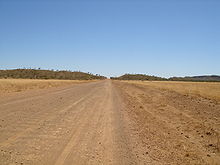
The track is a graded, dirt road and although navigable by two-wheel drive vehicles, a four-wheel drive is recommended. Some parts of the road are prone to severe corrugations, making for an uncomfortable and slow drive at times. The mid-way point: Rabbit Flat, formerly a public roadhouse, was closed indefinitely at the end of 2010, so planning for this journey must take the lack of fuel and supplies into account. [4] Another Roadhouse, located 206 km (128 mi) from Alice Springs between Alice Springs and Rabbit Flat: Tilmouth Well[5] provides fuel service 7 days a week.[4] Carrying adequate fuel and water supplies is essential.
Eugene Shoemaker died along this route in a car accident in 1997.
See also
References
- ^ Design Interaction (Firm) & Walker, Greg & Walker, Josie (2007). In Tanami Road with regional roads and public access routes : Alice Springs, Tilmouth Well Roadhouse, Yuendumu, Rabbit Flat, Balgo, Billiluna, Halls Creek, Old Halls Creek, Bungle Bungle. Design Interaction, Bundoora, Vic
- ^ Walker, Greg (2007). In Tanami Road. Design Interaction Eight Mile Plains : Hema Maps Pty, Limited [Distributor], Bundoora
- ^ Yuendumu Mining Company N.L (1980). In The Tanami road : the Aboriginal-owned Yuendumu Mining Company N.L. submission to Parliamentary Standing Committee on Public Works. Yuendumu Mining Company N.L, Darwin
- ^ a b "The Tanami Desert, Australia". Outback Australia Travel Guide. http://www.outback-australia-travel-secrets.com/tanami-desert.html. Retrieved 2011-04-22.
- ^ http://www.tilmouthwell.com/ Tilmouth Well
Further reading
- Deckert, John.(1993) Tanami Track map - Nhill, Vic : Westprint Heritage Maps, 1992. Scale 1:1,000,000 (E 127°20' -- E 134°00/S 17°25' -- S 24°00'). ISBN 1875608117
External links
 Road infrastructure in Northern Territory
National Highways 
Highways Outback tracks Buchanan Highway • Buntine Highway • Duncan Road • Great Central Road • Gunbarrel Highway • Plenty Highway • Sandover Highway • Savannah Way • Tanami Road Road infrastructure in Western Australia
Freeways Metropolitan highways Highways and major roads Albany Highway • Brand Highway • Brockman Highway • Brookton Highway • Bussell Highway • Coalfields Road • Coolgardie-Esperance Highway • Dampier Highway • Derby Highway • Eyre Highway • Forrest Highway • Geraldton-Mount Magnet Road • Goldfields Highway • Great Eastern Highway • Great Northern Highway • Great Southern Highway • Indian Ocean Drive • Mandjoogoordap Drive • Muirs Highway • North West Coastal Highway • Old Coast Road • South Coast Highway • South Western Highway • Vasse Highway • Victoria HighwayOutback Tracks Anne Beadell Highway • Buntine Highway • Canning Stock Route • Cape Leveque Road • Connie Sue Highway • Duncan Road • Gary Highway • Gibb River Road • Great Central Road • Gunbarrel Highway • Kalumburu Road • Tanami RoadCategories:- Droving Roads
- Australian outback tracks
- Kimberley (Western Australia)
- Roads in the Northern Territory

Wikimedia Foundation. 2010.