- Decatur Airport
-
For the airport in Decatur, Texas, see Decatur Municipal Airport.
Decatur Airport 
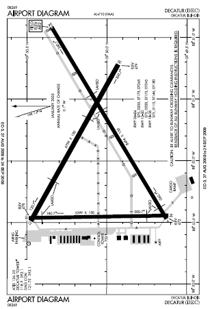
FAA airport diagram (August 2009) IATA: DEC – ICAO: KDEC – FAA LID: DEC Summary Airport type Public Owner Decatur Park District Serves Decatur, Illinois Elevation AMSL 682 ft / 208 m Coordinates 39°50′04″N 088°51′56″W / 39.83444°N 88.86556°W Website Runways Direction Length Surface ft m 6/24 8,496 2,590 Asphalt/Concrete 12/30 6,799 2,072 Asphalt/Concrete 18/36 5,299 1,615 Asphalt Statistics (2008) Aircraft operations 44,614 Based aircraft 90 Source: Federal Aviation Administration[1] Decatur Airport (IATA: DEC, ICAO: KDEC, FAA LID: DEC) is a public use airport located four nautical miles (7 km) east of the central business district of Decatur, a city in Macon County, Illinois, United States. It is owned by the Decatur Park District.[1]
The airport is used for general aviation, but mostly for one commercial airline. Service is subsidized by the Essential Air Service program.
Contents
Facilities and aircraft
Decatur Airport covers an area of 2,100 acres (850 ha) at an elevation of 682 feet (208 m) above mean sea level. It has three paved runways: 6/24 is 8,496 by 150 feet (2,590 x 46 m); 12/30 is 6,799 by 150 feet (2,072 x 46 m); 18/36 is 5,299 by 150 feet (1,615 x 46 m).[1]
For the 12-month period ending December 31, 2008, the airport had 44,614 aircraft operations, an average of 122 per day: 77.5% general aviation, 16.7% military. 5.7% air taxi, and 0.1% scheduled commercial, At that time there were 90 aircraft based at this airport: 64.4% single-engine, 7.8% multi-engine, 5.6% jet, 6.7% helicopter and 15.6% military.[1]
Decatur Airport maintains a 24,000 square feet (2,200 m) passenger terminal building that contains airline counters, a restaurant, the baggage claim area and a car rental facility.
The Illinois Army National Guard operates an Army Aviation Support Facility (AASF) at the airport. The facility occupies 10 acres (4.0 ha) and has 3 permanent buildings and 1 temporary building on the site.[2]
Airlines and destinations
Airlines Destinations Air Choice One Chicago-O'Hare, St. Louis Accidents and incidents
- On August 3, 1950 a United States Air Force Douglas C-47D was destroyed by fire after a take-off related accident.[3] All 5 occupants survived the crash and subsequent fire.[3]
- On October 2, 2006 a United States Air Force Learjet C-21A was on a training mission flying a simulated approach to runway 24 when the planes speed unexpectedly dropped and called out "speed" two times.[4] The pilot pulled back the number one engine throttle but the plane began to roll steeply to the right and struck the pavement before proceeding to skid through a grass infield and then across another runway before coming to a stop.[4] Both occupants survived but were also determined to be at fault for the crash.[4][5]
- On the afternoon of Thursday, December 2, 2010, it was reported by the online edition of the Peoria Journal Star that the Federal Aviation Administration stated that the pilot of a small airplane was killed after a crash. FAA spokesman Tony Molinaro says the single-engine home-built aircraft took off from Decatur Airport on Thursday afternoon and crashed 1.5 miles east of the airport. Molinaro said the pilot was the only one on board. The pilot's name was not released. The plane was manufactured in 2010 and is called a "Freebird Lite Sport". It was destroyed in the crash. The National Transportation Safety Board (NTSB) is investigating.
References
- ^ a b c d FAA Airport Master Record for DEC (Form 5010 PDF). Federal Aviation Administration. Effective 11 February 2010.
- ^ "Decatur, Illinois". Illinois Army National Guard. http://www.il.ngb.army.mil/Army/ArmoryLocations.asp?city=DECATUR. Retrieved 2009-09-06.[dead link]
- ^ a b "03 AUG 1950". National Transportation Safety Board (NTSB). Aviation Safety Network. November 27, 2004. http://aviation-safety.net/database/record.php?id=19500803-0. Retrieved 2009-09-05.
- ^ a b c "02 OCT 2006". National Transportation Safety Board (NTSB)/FAA. Aviation Safety Network. October 3, 2006. http://aviation-safety.net/database/record.php?id=20061002-0. Retrieved 2009-09-06.
- ^ "C-21 Accident Investigation Board completed". Scott Air Force Base, Ill. United States Air Force. May 11, 2007. http://www.af.mil/news/story.asp?id=123052938. Retrieved 2009-09-06.
External links
- Decatur Airport, official site
- Aerial photo as of 14 April 1998 from USGS The National Map
- FAA Airport Diagram (PDF), effective 20 October 2011
- FAA Terminal Procedures for DEC, effective 20 October 2011
- Resources for this airport:
- AirNav airport information for KDEC
- ASN accident history for DEC
- FlightAware airport information and live flight tracker
- NOAA/NWS latest weather observations
- SkyVector aeronautical chart for KDEC
- FAA current DEC delay information
Aviation in Illinois Primary airports O'Hare International Airport · Chicago Midway International Airport · Quad City International Airport · Central Illinois Regional Airport · General Wayne A. Downing Peoria International Airport · University of Illinois Willard Airport · Chicago Rockford International Airport · Abraham Lincoln Capital Airport · MidAmerica St. Louis Airport · Decatur Airport · Williamson County Regional Airport 
Military Airlines Air Illinois (1970-1984) · Chicago Air (1985-1986) · Festival Airlines (2006) · Midway Airlines (1976-1991) · Mississippi Valley Airlines (1969-1985) · United Airlines (founded 1927) Aviation-related List of airports in Illinois Categories:- Airports in Illinois
- Decatur, Illinois
- Buildings and structures in Macon County, Illinois
- Essential Air Service
Wikimedia Foundation. 2010.