- Clifton, Cumbria
-
Coordinates: 54°37′55″N 2°43′23″W / 54.632°N 2.723°W
Clifton 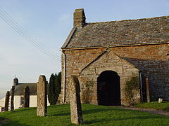
Old Church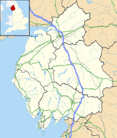
 Clifton
Clifton shown within CumbriaPopulation 461 (2001) OS grid reference NY5326 Parish Clifton District Eden Shire county Cumbria Region North West Country England Sovereign state United Kingdom Post town PENRITH Postcode district CA10 Dialling code 01768 Police Cumbria Fire Cumbria Ambulance North West EU Parliament North West England UK Parliament Penrith and the Border List of places: UK • England • Cumbria Clifton is a small linear village and civil parish 3 miles (4.8 km) south east of Penrith in Cumbria, England.
Contents
History and geography
The civil parish of Clifton has its western boundary defined by the River Lowther, to the north and east lie the civil parishes of Brougham and Great Strickland, to the south is the civil parish of Lowther.
Most of the hamlet of Clifton Dykes (on the C3047 road) also lies within the parish. The name of this was shown as Longchimney on the first edition Ordnance Survey map of 1897, and then as Clifton Dikes on the later second edition. The current spelling was settled on more recently.
The village of Clifton has a church, primary school, a pub and a hotel.[citation needed]
Clifton Moor Battle
Main article: Clifton Moor SkirmishClifton Moor was the site, in 1745, of the final battle in England (and the last battle ever on English soil) between Bonnie Prince Charlie and the Duke of Cumberland.
The story of a local family, the Wybergs, whose property was forcibly sold by Oliver Cromwell in 1652, is told in Sir Walter Scott's novel, Waverley, which also features the battle on Clifton Moor.
St. Cuthbert's church
The local church, St Cuthbert's, contains the graves of 10 men killed in battle of Clifton Moor. Some of the remains of St Cuthbert are also said to be languishing in the church. St Cuthbert's church contains a monument to a local benefactress, Eleanor Engayne, who died about the year 1395 ; according to the Topography and Directory of Westmorland, 1851, the manor of Clifton was given in the reign of Henry II, by Hugh de Morville, one of Thomas Becket's murderers, to Gilbert de Engayne, with whose descendants it continued till their heiress, Eleanor, in 1364, carried it in marriage to William de Wyberg.[1]
Transport
There once were two railway stations, the 1846 Clifton station (later named Clifton and Lowther railway station) was on the Lancaster and Carlisle Railway (now part of the West Coast Main Line WCML), it closed to passengers in 1938.[2]
Another station Clifton Moor station was on the Eden Valley Railway and opened 1863, closing in 1962.[3] Confusingly Clifton & Lowther Station was at a hamlet known as Clifton Moor. The nearest station is now Penrith railway station.
At the boundary with the civil parish of Yanwath and Eamont Bridge where the west coast mainline railway crosses the river Lowther is Hugh's Crag Viaduct (also known as Lowther Viaduct[4], or Clifton Viaduct[5]) built in 1846.[6]
The M6 motorway now also runs through the parish.
Other
Wetheriggs Pottery also is within the civil parish, east of the village.
Clifton Hall, a 15th century Pele tower.
See also
- John "Iron-Mad" Wilkinson, the industrialist, was born in Clifton in 1728.
References
- ^ Clifton , Extract from the History, Topography and Directory of Westmorland , Mannix & Co. , 1851 , via www.stevebulman.f9.co.uk
- ^ Clifton and Lowther www.disused-stations.org.uk
- ^ Clifton Moor www.disused-stations.org.uk
- ^ Opening of the Lancaster and Carlisle Railway Tuesday Last , The Illustrated London News , 19 December 1846 , online reprint via home.clara.net , also reprinted in Nineteenth-Century railway history through the Illustrated London news , Anthony J. Lambert , 1984
- ^ Hugh's Crag Viaduct, Yanwath and Eaton Bridge www.britishlistedbuildings.co.uk
- ^ Lowther Viaduct www.engineering-timelines.com
Further information
- History, topography, and directory, of Westmorland: and Londsdale north of the sands, in Lancashire together with a descriptive and geological view of the whole of the Lake district , P. J. Mannex , 1849 , "Clifton Parish" pp.218-219, other pages , google books
External links
- Clifton , The Cumbria Directory , www.thecumbriadirectory.com
- Clifton Standing Stones www.megalithic.co.uk
- Clifton - Moor - "The Battle of" Contemporary account of the Battle of Clifton Moor by Thomas Savage, of Clifton End Farm , 1745 , via edenlinks.rootsweb.com
- Clifton Tower Hall , English Heritage , www.english-heritage.org.uk
Ceremonial county of Cumbria Cumbria Portal Boroughs or districts City of Carlisle • Borough of Allerdale • Borough of Barrow-in-Furness • Borough of Copeland • District of Eden • District of South LakelandMajor settlements Alston • Ambleside • Appleby-in-Westmorland • Aspatria • Barrow-in-Furness • Bowness-on-Windermere • Brampton • Broughton-in-Furness • Carlisle • Cleator Moor • Cockermouth • Dalton-in-Furness • Egremont • Grange-over-Sands • Harrington • Kendal • Keswick • Kirkby Lonsdale • Kirkby Stephen • Longtown • Maryport • Millom • Penrith • Sedbergh • Silloth • Ulverston • Whitehaven • Wigton • Windermere • Workington
See also: List of civil parishes in CumbriaTopics Demography • Economy • Education • Geography • History • People • Places of interest • Settlements • Sport • Symbols and county emblems • TransportCategories:- Villages in Cumbria
- Civil parishes in Cumbria


Wikimedia Foundation. 2010.