- Chillingham Road Metro station
-
Chillingham Road 
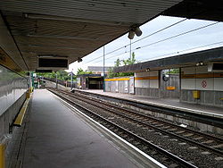
Chillingham Road station viewed from platform 2 in June 2009 Location Place Heaton Local authority Newcastle Fare zone information Network One zone 1 Metro zone A Original (1979) zone 27 Station code CRD History Opened 1982-11-14 Tyne and Wear Metro
List of Tyne and Wear Metro stationsChillingham Road Metro station is located in the south of the Heaton area of Newcastle upon Tyne, and is served by the Tyne and Wear Metro service. It was originally to be called Parsons, reflecting its proximity to the Parsons engineering works. It is located adjacent to the tracks of Heaton TMD and the East Coast Main Line at the end of a long path from Chillingham Road, and is unusual in that electronic displays showing the arrival times of the next trains were only installed in 2009.
Close to the station is Brough Park Stadium, which holds regular greyhound racing meetings and is home to the Newcastle Diamonds speedway team. Chillingham Road is also the closest Metro station to the location of the former Heaton railway station. West of here, the Metro route diverges from the former North Eastern Railway line through Heaton in order to serve Byker. Immediately east of the station there was a track connection into Heaton depot and into the Parsons works, but rail traffic into Parsons ceased just before this section of the Metro opened. The connection remained in place, however, until BR resignalling of Heaton depot at the end of the decade.
Chillingham Road was the first surface station to undergo major renovation, being completed in October 2011[1].
Ticketing anomalies
Different zonal fare systems are used for Metro single tickets and inter-modal Transfare tickets, which means that for a number of journeys a Transfare may actually be cheaper than a standard Metro-only ticket.
Station Network Zone Metro Zone Cullercoats 29 C North Shields 29 C Tynemouth 29 C Wallsend 27 B References
External links
- Train times and station information for Chillingham Road Metro station from Nexus
Coordinates: 54°58′58″N 1°34′18″W / 54.9829°N 1.5718°W
Preceding station Tyne and Wear Metro Following station towards St JamesYellow line towards
This United Kingdom rapid transit article is a stub. You can help Wikipedia by expanding it.
