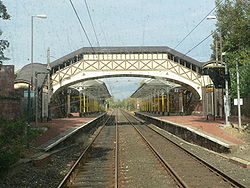
- Cullercoats Metro station
-
Cullercoats 
Cullercoats Metro station in 2005 Location Place Cullercoats Local authority North Tyneside Fare zone information Network One zone 3 Metro zone C Original (1979) zone 29 Station code CUL History Opened 7 July 1882 Closed for conversion 1979-09-10 Metro since 11 August 1980 Tyne and Wear Metro
List of Tyne and Wear Metro stationsCullercoats Metro station is the Tyne and Wear Metro station serving Cullercoats on the North Tyneside coast. It was originally built by the North Eastern Railway as part of the North Tyneside Loop. It first opened on the 7 July 1882 and has been exclusively operated by the Tyne and Wear Metro since the opening day of the system on 11 August 1980.
The original buildings have been retained and as such Cullercoats station is one of the most architecturally interesting on the Metro network. The present station replaced an earlier one built in 1865, which was located further inland, about half way up what is now Farringdon Road. This section of the railway ran between Tynemouth and Whitley Junction (now Monkseaton Metro station), with Cullercoats being the only stop in between.
Cullercoats is one of several Metro stations identified as hot-spots for juvenile delinquency. As a deterrent, the Metro operator Nexus pipes classical music across the station tannoy.[1]
Contents
Ticketing anomalies
Different zonal fare systems are used for Metro single tickets and inter-modal Transfare tickets, which means that for a number of journeys a Transfare may actually be cheaper than a standard Metro-only ticket.
Station Network Zone Metro Zone Byker 27 A Chillingham Road 27 A See also
References
- ^ "Nexus welcomes classical music at Stanley Bus Station" (Press release). Nexus. 2005-12-23. http://www.nexus.org.uk/wps/wcm/connect/Nexus/Nexus/News/News+archive/2005/Nexus+welcomes+classical+music+at+Stanley+Bus+Station. Retrieved 2007-01-28.
External links
- Train times and station information for Cullercoats Metro station from Nexus
Coordinates: 55°02′06″N 1°26′11″W / 55.0350°N 1.4363°W
Preceding station Tyne and Wear Metro Following station towards St JamesYellow line towards South Shields
This United Kingdom rapid transit article is a stub. You can help Wikipedia by expanding it.
