- Nome Airport
-
Nome Airport 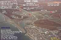
IATA: OME – ICAO: PAOM – FAA LID: OME Location of airport in Alaska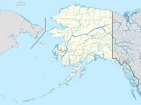
 OME
OMESummary Airport type Public Owner Alaska DOT&PF - Northern Region Serves Nome, Alaska Elevation AMSL 37 ft / 11 m Coordinates 64°30′44″N 165°26′43″W / 64.51222°N 165.44528°W Runways Direction Length Surface ft m 3/21 5,576 1,700 Asphalt 10/28 6,001 1,829 Asphalt Statistics (2008) Aircraft operations 28,000 Based aircraft 71 Source: Federal Aviation Administration[1] Nome Airport (IATA: OME, ICAO: PAOM, FAA LID: OME) is a state-owned public-use airport located two nautical miles (3.7 km) west of the central business district of Nome, a city in the Nome Census Area of the U.S. state of Alaska.[1]
The State of Alaska also operates Nome City Field (FAA LID: 94Z), a public general aviation airfield located one nautical mile (1.85 km) north of the city.[2][3]
Contents
Facilities and aircraft
Nome Airport has two asphalt paved runways: 3/21 measures 5,576 by 150 feet (1,700 x 46 m) and 10/28 is 6,001 by 150 feet (1,829 x 46 m).[1]
For the 12-month period ending November 1, 2008, the airport had 28,000 aircraft operations, an average of 76 per day: 54% air taxi, 36% general aviation, 5% scheduled commercial and 5% military. At that time there were 71 aircraft based at this airport: 72% single-engine, 17% multi-engine, 7% helicopter and 4% military.[1]
Free parking is available at the airport.
Airport Pizza
Located near the airport is a pizza restaurant named Airport Pizza. The pizza parlor is famous for its use of Bering Air flights to deliver pizza for free to far-flung Alaskan villages.[4]
Airlines and non-stop destinations
Airlines Destinations Alaska Airlines Anchorage, Kotzebue Arctic Transportation Services Brevig Mission, Elim, Gambell, Golovin,Savoonga, Shishmaref, Teller, Unalakleet, Wales, White Mountain Bering Air Anadyr, Brevig Mission, Council, Elim, Gambell, Golovin, Kotzebue, Koyuk, Little Diomede, Port Clarence, Provideniya, Saint Michael, Savoonga, Shaktoolik, Shishmaref, Stebbins, Teller, Tin City, Unalakeet, Wales, White Mountain[5] Era Alaska Unalakleet, Galena Evergreen Helicopters Wales, Little Diomede Frontier Flying Service Hageland Aviation Services Elim, Gambell, Golovin, Savoonga, Shaktoolik, Shishmaref, Stebbins, White Mountain, Brevig Mission, Teller, Wales, Unalakeet[6] Military use
Nome Airport was used as a transport base during World War II, facilitating the transit of Lend-Lease aircraft to the Soviet Union. Known as Marks Army Airfield it shared the facility with the civilian Nome Airport. It also was used as a defensive airfield in 1942 by the United States Army Air Force for the western coast of Alaska. Known USAAF units assigned were:
- 404th Bombardment Squadron (July 18–28, 1942) (28th BG)
- 56th Fighter Squadron (June 20 – October 20, 1942) (54th FG)
Renamed Marks Air Force Base in 1948, it was used as a cold weather survival school and a fighter-interceptor forward base. Marks was too close to the USSR to operate defending fighter-interceptors, so they were pulled back to Galena Airport. Although Marks AFB closed in 1950, an air base squadron was at Nome Airport until December 1956.
See also
References
 This article incorporates public domain material from websites or documents of the Air Force Historical Research Agency.
- Maurer, Maurer (1983). Air Force Combat Units Of World War II. Maxwell AFB, Alabama: Office of Air Force History. ISBN 0-89201-092-4.
- Mauer, Mauer (1969), Combat Squadrons of the Air Force, World War II, Air Force Historical Studies Office, Maxwell AFB, Alabama. ISBN 0-89201-097-5
- ^ a b c d FAA Airport Master Record for OME (Form 5010 PDF), effective 2009-05-07.
- ^ FAA Airport Master Record for 94Z (Form 5010 PDF), effective 2009-05-07.
- ^ Nome Alaska Economy and Transportation
- ^ http://www.fodors.com/world/north-america/usa/alaska/kodiak-nome-and-the-bush/review-471134.html
- ^ Bering Air: Nome Flight Schedule. Retrieved 1 June 2009.
- ^ Hageland Aviation Services: Scheduled Flights. Retrieved 1 June 2009.
External links
- FAA Alaska airport diagram (GIF)
- FAA Airport Diagram for Nome Airport (OME) (PDF), effective 20 October 2011
- FAA Terminal Procedures for Nome Airport (OME), effective 20 October 2011
- Resources for this airport:
- AirNav airport information for PAOM
- ASN accident history for OME
- FlightAware airport information and live flight tracker for PAOM
- NOAA/NWS latest weather observations for PAOM
- SkyVector aeronautical chart for OME
 USAAF Eleventh Air Force in World War IIPreviously: Alaskan Air Force (1941-1942)
Airfields Adak · Alexai Point · Amchitka · Attu · Elmendorf · Fort Glenn · Fort Randall · Gakona · Galena · Gambell · Kiska · Ladd · Mile 26 · Marks · Ogliuga Island · Juneau · Fort Morrow · Shemya · Yakutat
Units Commands XI Bomber · XI FighterGroups Bombardment 28th BombardmentFighter Categories:- Airports in the Nome Census Area, Alaska
- USAAF Air Transport Command Airfields - Alaska
- Airfields of the United States Army Air Forces in Alaska


Wikimedia Foundation. 2010.