- Edward G. Pitka Sr. Airport
-
Edward G. Pitka Sr. Airport 
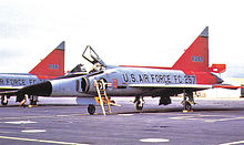
IATA: GAL – ICAO: PAGA – FAA LID: GAL Summary Airport type Public Owner Alaska DOT&PF - Northern Region Location Galena, Alaska Elevation AMSL 153 ft / 47 m Coordinates 64°44′10″N 156°56′15″W / 64.73611°N 156.9375°W Runways Direction Length Surface ft m 7/25 7,249 2,209 Asphalt/Concrete 6/24 2,786 849 Gravel Statistics Based aircraft 13 Source: Federal Aviation Administration[1]  Galena Airport was used by the USAF 317th Fighter-Interceptor Squadron at Elmendorf AFB as a forward-deployed Base to intercept Soviet aircraft intruding on United States airspace over the Bering Sea. This aircraft, Convair F-102A-70-CO Delta Dagger 56-1257, 1965. Aircraft was retired to MASDC as FJ0367 Mar 16, 1975. Converted to QF-102A, later to PQM-102B and later expended as an aerial target during the 1980s at Holloman AFB, New Mexico
Edward G. Pitka Sr. Airport (IATA: GAL, ICAO: PAGA, FAA LID: GAL) is a state-owned public-use airport located in Galena, a city in the Yukon-Koyukuk Census Area of the U.S. state of Alaska.[1]
Contents
Facilities
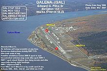
Edward G. Pitka Sr. Airport covers an area of 1,250 acres (510 ha) which contains two runways: 7/25 with an asphalt/concrete pavement measuring 7,249 by 150 feet (2,209 x 46 m) and 6/24 with a gravel surface measuring 2,786 by 80 feet (849 x 24 m).[1]
The airport also sports a ski-jump takeoff ramp at one end and provisions for arresting gear (see picture, ski jump at 07 end) at the other, a leftover from the Cold War years as Galena Air Force Base, as tactical aircraft required more landing and takeoff space than was available on the runway.
Airlines and non-stop destinations
- Arctic Circle Air (Fairbanks) [2]
- Everts Air
- Era Alaska Aviation (Anchorage, Fairbanks, Huslia, Kaltag, Koyukuk, Nulato, Ruby)[3]
- Warbelow's Air Ventures
Top Destinations
Busiest domestic routes out of GAL
(June 2010 - May 2011) [4]Rank City Passengers Carriers 1  Fairbanks, AK
7,000 Arctic Circle, Era Alaska 2  Nulato, AK
2,000 Era Alaska 3  Kaltag, AK
1,000 Era Alaska Military use
Galena Airport was used as a transport base during World War II, facilitating the transit of Lend-Lease aircraft to the Soviet Union.
Galena Air Force Base was also used by the USAF during the Cold War as an interceptor base for aircraft patrolling the western areas of Alaska. It was closed in 1993, however the military airfield is maintained by a private contractor as a weather/emergency diversion airfield since Regular Air Force fighter-interceptor alert operations ended
See also
References
 This article incorporates public domain material from websites or documents of the Air Force Historical Research Agency.
- ^ a b c FAA Airport Master Record for GAL (Form 5010 PDF), effective 2007-07-05
- ^ Fairbanks Schedule. Arctic Circle Air. 24 April 2006.
- ^ 2007 Timetable (PDF). Frontier Flying Service. Retrieved 29 August 2007.
- ^ http://www.transtats.bts.gov/airports.asp?pn=1&Airport=GAL&Airport_Name=Galena,%20AK:%20Galena%20Airport&carrier=FACTS
www.flyera.com
External links
- FAA Alaska airport diagram (GIF)
- FAA Airport Diagram for Edward G. Pitka Sr. Airport (GAL) (PDF), effective 20 October 2011
- FAA Terminal Procedures for Edward G. Pitka Sr. Airport (GAL), effective 20 October 2011
- Resources for this airport:
- AirNav airport information for PAGA
- ASN accident history for GAL
- FlightAware airport information and live flight tracker for PAGA
- NOAA/NWS latest weather observations for PAGA
- SkyVector aeronautical chart for GAL
 USAAF Eleventh Air Force in World War IIPreviously: Alaskan Air Force (1941-1942)
Airfields Adak · Alexai Point · Amchitka · Attu · Elmendorf · Fort Glenn · Fort Randall · Gakona · Galena · Gambell · Kiska · Ladd · Mile 26 · Marks · Ogliuga Island · Juneau · Fort Morrow · Shemya · Yakutat
Units Commands XI Bomber · XI FighterGroups Bombardment 28th BombardmentFighter Categories:- Airports in the Yukon–Koyukuk Census Area, Alaska
- USAAF Air Transport Command Airfields - Alaska
- Airfields of the United States Army Air Forces in Alaska
Wikimedia Foundation. 2010.

