- Unalakleet Airport
-
Unalakleet Airport 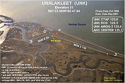
IATA: UNK – ICAO: PAUN – FAA LID: UNK Summary Airport type Public Owner State of Alaska DOT&PF Serves Unalakleet, Alaska Elevation AMSL 21 ft / 6 m Coordinates 63°53′18″N 160°47′56″W / 63.88833°N 160.79889°W Runways Direction Length Surface ft m 15/33 5,900 1,798 Asphalt 8/26 1,900 579 Asphalt Source: Federal Aviation Administration[1] Unalakleet Airport (IATA: UNK, ICAO: PAUN, FAA LID: UNK) is a state-owned public-use airport located one nautical mile (2 km) north of the central business district of Unalakleet, a city in the Nome Census Area of the U.S. state of Alaska.[1]
Contents
Facilities and aircraft
Unalakleet Airport covers an area of 5,837 acres (2,362 ha) at an elevation of 21 feet (6 m) above mean sea level. It has two asphalt surfaced runways: 15/33 measuring 5,900 x 150 ft (1,798 x 46 m) and 8/26 measuring 1,900 x 75 ft (579 x 23 m).[1]
Airlines and non-stop destinations
Airlines Destinations Bering Air Elim, Golovin, Koyuk, Nome, St. Michael, Shaktoolik, Stebbins, White Mountain Era Alaska Anchorage, Cordova, Fairbanks, Homer, Kenai, Kodiak, Koyuk, Nome, Saint Michael, Stebbins References
External links
- FAA Alaska airport diagram (GIF)
- FAA Terminal Procedures for UNK, effective 20 October 2011
- Resources for this airport:
- AirNav airport information for PAUN
- ASN accident history for UNK
- FlightAware airport information and live flight tracker for PAUN
- NOAA/NWS latest weather observations for PAUN
- SkyVector aeronautical chart for UNK
Categories:- Airports in the Nome Census Area, Alaska
- Alaska airport stubs

Wikimedia Foundation. 2010.