- Masai, Johor
-
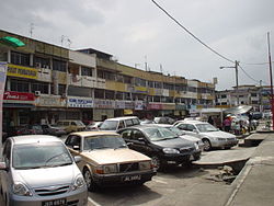
Masai Masai main street. Masai in Malaysia Coordinates: 1°29′36.4986″N 103°52′40.9404″E / 1.493471833°N 103.878039°E Country Malaysia State Federal Territory of Johor Bahru Time zone MST (UTC+8) Postcode 81750 Dialling code +60 07 Masai is a town located in east Johor Bahru District, Malaysia, and is the oldest part of Johor Bahru. It is located 25 kilometres from the Johor Bahru city centre. Masai is located on route J10 which leads to Kong Kong, a fishing village along Johor River. The main access roads to Masai are Jalan Masai Lama(J10) and Pasir Gudang Highway(Federal Route 17).
Many pre-war buildings are still well preserved. Masai, like many of the towns in the Johor Bahru district, catered to the rural population of farmers and rubber plantation workers throughout the early and mid 20th century.
Due to its proximity to Pasir Gudang, its shops cater to retail shoppers from Pasir Gudang as well as from the rapidly growing population of nearby housing estates such as Kota Masai, Bandar Seri Alam, Taman Rinting, Taman Megah Ria, Nusa Damai, Taman Scientex, Kota Puteri and Taman Bukit Dahlia.
Recent history
Masai has gone through vigorous development which has transformed the town into one of the most populous towns in Johor. The Masai Chinese Primary School now has more than 5000 pupils. Shops include Todays, Yos Saver Store, Kip-Mart and Tesco.
Bandar Sri Alam is the business centre for Masai, with MayBank, Public Bank, CIMB and Bank Rakyat and hotels.
The Masai Main Street, Jalan Masai Lama, is the main road connecting Johor Bahru to towns at the east side of Masai such as Kota Masai, Kong Kong and Pasir Gudang.
Schools in Masai
- SMK TAMAN RINTING 2
- Sekolah Kebangsaan Masai
- Sekolah Jenis Kebangsaan(C) Masai
- Sekolah Jenis Kebangsaan(T) Masai
- Sekolah Menengah Kebangsaan Dato' Penggawa Timur
 Iskandar Malaysia
Districts Key Entities Khazanah Nasional · Iskandar Regional Development Authority · Iskandar Investment Berhad · Kumpulan Prasarana Rakyat Johor · Johor Corporation · UEM Group · Ekovest BerhadLocal Authorities Majlis Daerah Pontian (MDP) · Majlis Perbandaran Johor Bahru Tengah (MPJBT) · Majlis Perbandaran Kulai (MPKu) · Majlis Bandaraya Johor Bahru (MBJB) · Majlis Perbandaran Pasir Gudang (MPPG)Economic Zones Zone A: Johor Bahru City Centre · Zone B: Nusajaya · Zone C: Western Gate Development · Zone D: Eastern Gate Development · Zone E: Senai-SkudaiMajor Towns Johor Bahru · Skudai · Nusajaya · Tanjung Kupang · Pasir Gudang · Larkin · Permas Jaya · Senai · Kulai · Saleng · Sedenak · Seelong · Bukit Batu · Kelapa Sawit · Ayer Bemban · Sengkang · Bandar Dato' Onn · Bandar Sri Alam · Tampoi · Gelang Patah · Ulu Tiram · Tanjung Langsat · Masai · Plentong · Danga Bay · Medini Iskandar MalaysiaMajor Landmarks Kota Iskandar (Johor State New Administrative Centre (JSNAC)) · Persada Johor · Johor-Singapore Causeway · Southern Integrated Gateway · Larkin Transport Terminal Complex and Central Market · Nusajaya · Malaysia–Singapore Second Link · Malaysia-Singapore Third Crossing · Johor Port · Port of Tanjung Pelepas · Permas Jaya Bridge · Sungai Johor Bridge · Iskandar Coastal Bridge · Johor Technology Park · Senai International Airport · Tanjung Piai · MSC Cyberport · Legoland MalaysiaInfrastructure Pasir Gudang Highway · Second Link Expressway · North-South Expressway Southern Route · JB Monorail · Senai-Desaru Expressway · JB Eastern Dispersal Link · Skudai Highway · Johor Bahru Inner Ring Road · Tebrau Highway · Iskandar Coastal Highway · Johor Bahru East Coast Highway · Gemas-Johor Bahru double-tracking and electrification projectEducation Categories:- Towns and suburbs in Johor Bahru District
- Populated places in Johor
Wikimedia Foundation. 2010.


