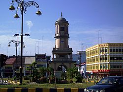
- Muar District
-
See also: Muar town
Muar District -
Daerah Muar (Malay) 麻坡县 (Chinese) முஅர் (Tamil)

Flag
SealMotto: "Cekap Amanah Dinamik Makmur" (Malay)
"Efficient Trustworthy Dynamic Prosperous"Coordinates: 2°3′00″N 102°34′00″E / 2.05°N 102.5666667°E Country Malaysia State Johor Government – District Officer Tuan Haji Mislan bin Karmani Area – Total 2,346.12 km2 (72.27 sq mi) Elevation 36.88 m (121 ft) Population (2007) – Total 437,167 – Density 140.8/km2 (364.7/sq mi) – Demonym Muarian Time zone MST (UTC+8) – Summer (DST) Not observed (UTC) Postal code 84xxx National calling code 06 License plate prefix Jxx Website http://www.mpmuar.gov.my http://www.johordt.gov.my/pdmuar Muar District is a district in the state of Johor, Malaysia. The name "Muar" is also used for the name of its district, which formerly sub-divided between the Town of Muar and the sub-district of Tangkak. Tangkak sub-district has been upgraded into a full district known as Ledang District in year 2008. Muar district formerly borders Malacca on the west coast of Peninsular Malaysia. Upon the upgrading of Ledang District, the Muar District now covers only the area on the southern portion of Muar River, whilst the northern side is now within Ledang District. However, both administrative regions are still collectively called Muar by their residents.
Muar District formerly covers 2346.12 km2, with a population of 328,695 (2000). The name originated from the word Muara or estuary in Malay.
Towns
Categories:- Districts of Johor
- Muar
- Johor geography stubs
-
Wikimedia Foundation. 2010.


