- Long Melford
-
Coordinates: 52°04′37″N 0°43′05″E / 52.077°N 0.718°E
Long Melford 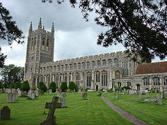
Holy Trinity Church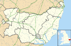
 Long Melford
Long Melford shown within SuffolkPopulation 3,675 [1] OS grid reference TL8646 District Babergh Shire county Suffolk Region East Country England Sovereign state United Kingdom Post town Sudbury Postcode district CO10 Dialling code 01787 Police Suffolk Fire Suffolk Ambulance East of England EU Parliament East of England UK Parliament South Suffolk List of places: UK • England • Suffolk Long Melford (or Melford, as it is known locally) is a large village and civil parish in the county of Suffolk, England. It is on Suffolk's border with Essex, which is marked by the River Stour, approximately 16 miles (26 km) from Colchester and 14 miles (23 km) from Bury St. Edmunds. The parish also includes the hamlets of Bridge Street and Cuckoo Tye.
Its name is derived from the nature of the village's layout (originally concentrated along a 3 mile stretch of a single road) and the Mill ford crossing the Chad Brook (a tributary of the River Stour).
Long Melford is notable for its large collection of antiques shops and dealers[citation needed]
Contents
History
The area now occupied by Long Melford has been occupied since at least 100 B.C..[citation needed] The village's layout was defined in Roman times[citation needed] with the empire building two roads thorough Melford, the main one running from Chelmsford through to Pakenham. Roman remains were discovered in a gravel pit in 1828,[2] a site now occupied by the village's football club.
The Manor of Melford was given to the Abbey of St.Edmundsbury by Earl Aflric in ca. 1050.[3] The village is recorded in the Domesday Book of 1086 which lists the manor of Long Melford as an estate of 600 hectares. The neighbouring Manor of Kentwell is also recorded. Following the dissolution of the Monasteries, Henry VIII granted the manor to Sir William Cordell.[3]
Landmarks
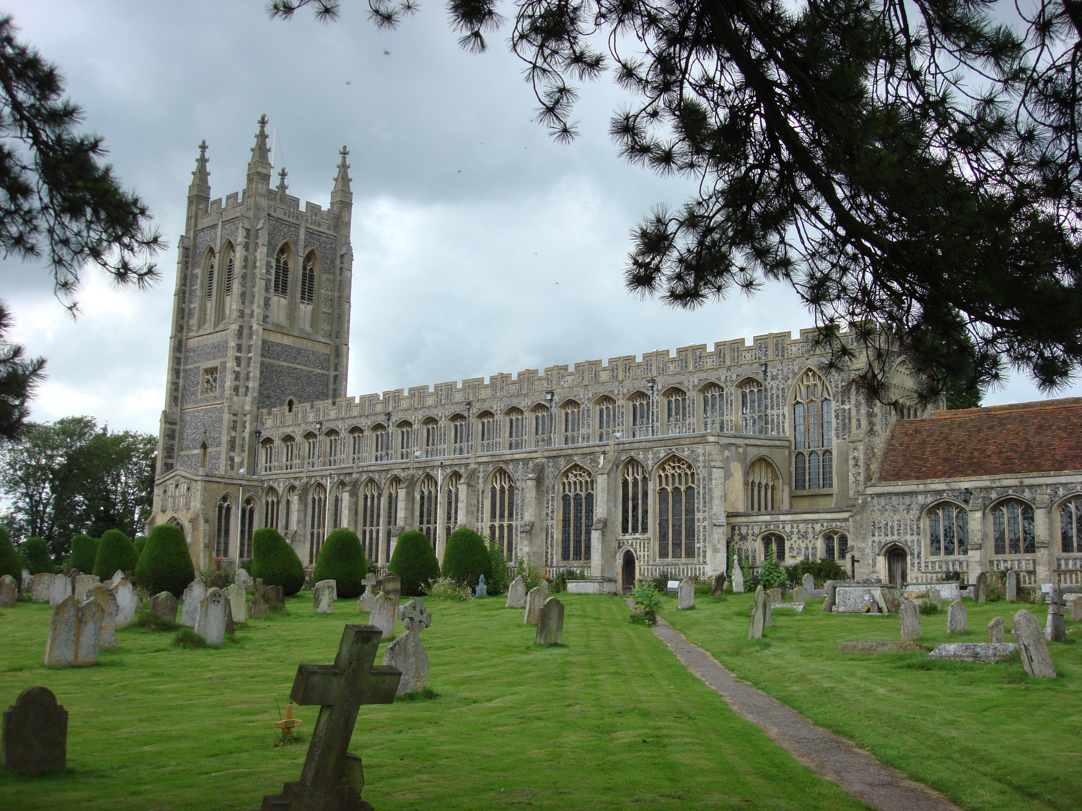
Long Melford is fairly unusual for a village in that it has a parish church of dimensions more suited to a cathedral. The origin of Holy Trinity Church dates from the reign of Edward the Confessor; it was then substantially rebuilt between 1467 and 1497 by John Clopton of Kentwell Hall. It is one of the richest "wool churches" in East Anglia and is renowned for its flushwork, The Clopton chantry chapel and the Lady Chapel at the East end with some surviving medieval stained-glass.[4] Edmund Blunden, the World War I poet, is buried in the churchyard. Next to the church is the Hospital of the Holy and Blessed Trinity, an almshouse founded by William Cordell in 1573.[5]
Another unusual feature of Long Melford is its large elongated village green, dominated until the 1980s by a group of great elms that included one of the largest in England.[6] The elms were painted in 1940 by the watercolourist S. R. Badmin in his 'Long Melford Green on a Frosty Morning', now in the Victoria and Albert Museum.[7]
The village contains two stately homes, Kentwell Hall and Melford Hall, all built from the proceeds of the wool trade in the Middle Ages. Kentwell Hall and the Holy Trinity Church were financed by the Clopton family, in particular by John Clopton.[8]
Transport
Long Melford once had a railway station on the Stour Valley Line, but this closed in March 1967 when the line was cut back to Sudbury. It is connected to several large towns by bus, notably Sudbury, Colchester, Bury St Edmunds, Haverhill and Ipswich.
See also
External links
References
- ^ Neighbourhood Statistics
- ^ Kelly (1900). Kelly's Directory of Suffolk. Kelly's Directories, Ltd.. p. 259. http://www.historicaldirectories.org/EXE/tiff2png.exe/00005RE2.PNG?-i+-r+80+-g+4+-h+1,130,3+E%3A%5CZYIMAGE%5CDATA%5CHISTDIR%5CTIF%5CLU8FD8%7E1%5C00005RE2.TIF. Retrieved 2008-10-21
- ^ a b Kelly (1900). Kelly's Directory of Suffolk. Kelly's Directories, Ltd.. p. 260. http://www.historicaldirectories.org/EXE/tiff2png.exe/00005RE3.PNG?-i+-r+80+-g+4+E%3A%5CZYIMAGE%5CDATA%5CHISTDIR%5CTIF%5CLU8FD8%7E1%5C00005RE3.TIF. Retrieved 2008-10-21
- ^ "Holy Trinity". The Diocese of St Edmundsbury and Ipswich. http://www.stedmundsbury.anglican.org/longmelford/. Retrieved 2008-09-16.
- ^ Charles Henry Cooper; Thompson Cooper (1858). Athenae Cantabrigienses. 1: 1500-1585. DEIGHTON BELL & CO, MACMILLAN & CO, BELL & DALDY FLEET STREET. p. 433. http://books.google.com/?id=8koJAAAAQAAJ&pg=PA433&dq=long+melford+hospital+cordell#v=onepage&q=long%20melford%20hospital%20cordell&f=false.
- ^ Photograph in Oliver Rackham, A History of the Countryside (London, 1986)
- ^ [1]
- ^ Britain Express
Babergh Towns Sudbury • HadleighCivil Parishes Acton · Aldham · Alpheton · Arwarton · Assington · Belstead · Bentley · Bildeston · Boxford · Boxted · Brantham · Brent Eleigh · Brettenham · Bures St Mary · Burstall · Capel St Mary · Chattisham · Chelmondiston · Chelsworth · Chilton · Cockfield · Copdock and Washbrook · East Bergholt · Edwardstone · Elmsett · Freston · Glemsford · Great Cornard · Great Waldingfield · Groton · Hadleigh (town) · Harkstead · Hartest · Higham · Hintlesham · Hitcham · Holbrook · Holton St Mary · Kersey · Kettlebaston · Lavenham · Lawshall · Layham · Leavenheath · Lindsey · Little Cornard · Little Waldingfield · Long Melford · Milden · Monks Eleigh · Nayland with Wissington · Nedging with Naughton · Newton · Pinewood · Polstead · Preston St Mary · Raydon · Semer · Shelley · Shimpling · Shotley · Somerton · Sproughton · Stanstead · Stoke by Nayland · Stratford St Mary · Stutton · Sudbury (town) · Tattingstone · Thorpe Morieux · Wattisham · Wenham Magna · Wenham Parva · Whatfield · Wherstead ·
WoolverstoneOther settlements Ash Street · Bower House Tye · Bridge Street · Broad Street · Burstallhill · Calais Street · Castling's Heath · Chelsworth Common · Cock Street · Cornard Tye · Cuckoo Tye · Dorking Tye · Drakestone Green · East End · Gosling Green · Hadleigh Heath · Honey Tye · Horner's Green · Humble Green · Kersey Tye · Kersey Upland · Lindsey Tye · Lower Holbrook · Lower Raydon · Mill Green · Naughton · Nayland · Nedging · Nedging Tye · Newman's Green · Parliament Heath · Polstead Heath · Priory Green · Rooksey Green · Rose Green, Assington · Rose Green, Lindsey · Round Maple · Sackers Green · Scotland Street · Smithwood Green · Swingleton Green · Sherbourne Street · Shop Corner · Stackyard Green · Stone Street · Tattingstone White Horse · Thorington Street · Upper Somerton · Washmere Green · Whelp Street · Whitestreet Green · Wicker Street Green · William's Green · Wissington · Washbrook · Washbrook Street · White Street Green · Withermarsh Green · Workhouse GreenBuildings: Abbas Hall · Flatford Mill · Kentwell Hall · Melford Hall · Milden Castle · St James's Chapel · Wattisham Strict Baptist Chapel · Willy Lott's Cottage · Woolverstone HallCategories:- Babergh
- Villages in Suffolk

Wikimedia Foundation. 2010.