- Chelmondiston
-
Coordinates: 51°59′22″N 1°12′31″E / 51.98950°N 1.20861°E
Chelmondiston 
St. Andrews Church, Chelmondiston
 Chelmondiston
Chelmondiston shown within SuffolkOS grid reference TM204372 District Babergh Shire county Suffolk Region East Country England Sovereign state United Kingdom Post town IPSWICH Postcode district IP9 Police Suffolk Fire Suffolk Ambulance East of England EU Parliament East of England UK Parliament South Suffolk List of places: UK • England • Suffolk Chelmondiston is a small village and civil parish in Suffolk, England, on the south bank of the River Orwell, located five miles south-east of Ipswich. It was formerly known as Chelmington and was located in the old Hundred of Babergh.
Contents
Churches
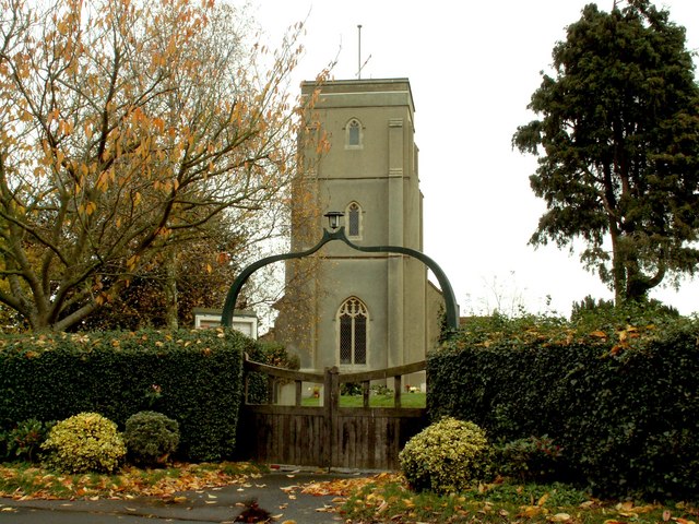
One night in late 1944, a German V2 rocket hit the small Hakewill's church in Chelmondiston. The little church was almost completely destroyed. In 1951, Basil Hatcher was commissioned to provide a replacement, St. Andrew's Church. It includes a set of stained glass windows made by Francis Skeat in the 1960s.[1]
There is a newer Methodist church on the Main Road and a Baptist church on Pin Mill Road.
Notable residents
- George Ratcliffe Woodward English composer.
- Princess Muna al-Hussein wife of Hussein of Jordan.
References
- ^ "St Andrew, Chelmondiston". Suffolk Churches. http://www.suffolkchurches.co.uk/chelmondiston.html. Retrieved 2 January 2011.
External links
- Village website - Chelmondiston Web Site
- Parish Council website
- BOHUN family
- St Andrew's Church
- Methodist church
- Chelmington
- Census 1881 http://www.censusfinder.com/england-census-records7.htm
Babergh Towns Sudbury • HadleighCivil Parishes Acton · Aldham · Alpheton · Arwarton · Assington · Belstead · Bentley · Bildeston · Boxford · Boxted · Brantham · Brent Eleigh · Brettenham · Bures St Mary · Burstall · Capel St Mary · Chattisham · Chelmondiston · Chelsworth · Chilton · Cockfield · Copdock and Washbrook · East Bergholt · Edwardstone · Elmsett · Freston · Glemsford · Great Cornard · Great Waldingfield · Groton · Hadleigh (town) · Harkstead · Hartest · Higham · Hintlesham · Hitcham · Holbrook · Holton St Mary · Kersey · Kettlebaston · Lavenham · Lawshall · Layham · Leavenheath · Lindsey · Little Cornard · Little Waldingfield · Long Melford · Milden · Monks Eleigh · Nayland with Wissington · Nedging with Naughton · Newton · Pinewood · Polstead · Preston St Mary · Raydon · Semer · Shelley · Shimpling · Shotley · Somerton · Sproughton · Stanstead · Stoke by Nayland · Stratford St Mary · Stutton · Sudbury (town) · Tattingstone · Thorpe Morieux · Wattisham · Wenham Magna · Wenham Parva · Whatfield · Wherstead ·
WoolverstoneOther settlements Ash Street · Bower House Tye · Bridge Street · Broad Street · Burstallhill · Calais Street · Castling's Heath · Chelsworth Common · Cock Street · Cornard Tye · Cuckoo Tye · Dorking Tye · Drakestone Green · East End · Gosling Green · Hadleigh Heath · Honey Tye · Horner's Green · Humble Green · Kersey Tye · Kersey Upland · Lindsey Tye · Lower Holbrook · Lower Raydon · Mill Green · Naughton · Nayland · Nedging · Nedging Tye · Newman's Green · Parliament Heath · Polstead Heath · Priory Green · Rooksey Green · Rose Green, Assington · Rose Green, Lindsey · Round Maple · Sackers Green · Scotland Street · Smithwood Green · Swingleton Green · Sherbourne Street · Shop Corner · Stackyard Green · Stone Street · Tattingstone White Horse · Thorington Street · Upper Somerton · Washmere Green · Whelp Street · Whitestreet Green · Wicker Street Green · William's Green · Wissington · Washbrook · Washbrook Street · White Street Green · Withermarsh Green · Workhouse GreenBuildings: Abbas Hall · Flatford Mill · Kentwell Hall · Melford Hall · Milden Castle · St James's Chapel · Wattisham Strict Baptist Chapel · Willy Lott's Cottage · Woolverstone HallCategories:- Babergh
- Villages in Suffolk
- Civil parishes in Suffolk
- Suffolk geography stubs

Wikimedia Foundation. 2010.