- Cockfield, Suffolk
-
Coordinates: 52°09′25″N 0°47′02″E / 52.1570°N 0.7840°E
Cockfield 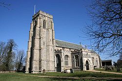
St Peter's Church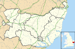
 Cockfield
Cockfield shown within SuffolkPopulation 839 OS grid reference TL905546 District Babergh Shire county Suffolk Region East Country England Sovereign state United Kingdom Post town BURY ST EDMUNDS Postcode district IP30 Dialling code 01284 Police Suffolk Fire Suffolk Ambulance East of England EU Parliament East of England UK Parliament South Suffolk List of places: UK • England • Suffolk Cockfield is a village and civil parish located approximately 3½ miles (5.6 km) from Lavenham in Suffolk, England. The village consists of a central point and several outlying hamlets: Buttons Green, Colchester Green, Cross Green, Great Green, Oldhall Green, Smithwood Green and Windsor Green. Surrounded mostly by fields used for farming, and with few roads, its population was 839 in 2001.
The village previously had a train station on the Long Melford-Bury St Edmunds branch line, but it was closed in 1961 as part of the Beeching Axe. Its football team, Cockfield United play in the Suffolk and Ipswich Football League.
Contents
History
The present village has been inhabited for well over 2000 years. The finding of a sword (now in the Moyse Hall Museum in Bury St Edmunds) is evidence of Bronze Age settlement, and a number of findings indicate a Roman encampment, known as the Warbanks.
The village's present name is derived from "Cochan-feld" probably indicating a site established by a person named Cochan. The village appeared in the Domesday Book of 1086 under the name of "Cothefelda" and is listed as a properous manor whose wealth had grown since the Norman Conquest. During the Middle Ages, the village became "Cokefield" and finally "Cockfield".
Cockfield became a centre a Puritanism during the 17th century. During the 19th century the parish was one of the largest and wealthiest in Suffolk and the seat of a number of prestigious rectors.[1]
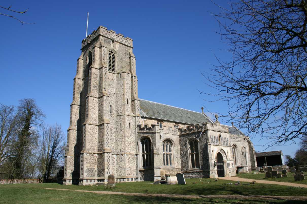
St Peter's Church
A landmark visible for a distance across the neighbouring countryside, the church of St Peter's is one of the finest of Suffolk's many village churches, with the present building mostly dating from the 14th and 15th centuries. The church's size is unusual for such a rural location, but this becomes less surprising when one considers its location between the three great medieval merchant towns of Bury St Edmunds, Lavenham, and Sudbury.
There is no record of a church in the Domesday Book although a village of Cockfield's size would almost certainly have had one. The first surviving record of the parish's ecclesiastical history dates from 1190 when William de Cullum was installed as the first rector, although there is no existing record of the site prior to the building of the present church in the 14th century.[2]
The church fell under the patronage of the Abbot of St Edmundsbury until the Reformation when the Spring family, wealthy Lavenham clothiers and noblemen, took over, resulting in a close link with the region's strong wool trade. From 1708 the patronage fell to St John's College, Cambridge who appointed a number of distinguished Fellows of the College. Rectors of St Peter's have included John Knewstub the Presbyterian, William Ludlam the mathematician, and Churchill Babington the archaeologist and botanist.
The church's sizeable square flint tower dates from the 14th century and is buttressed almost to the top. The tower was nearly destroyed by a storm during the winter of 1774-5 and on August 2, 1775, after repairs were nearly completed, an apparent lightning strike resulted in a fire that damaged it once again. The mathematician William Ludlam, rector from 1767, installed an astronomical observatory on the tower whose filled in windows can still be seen.[1]
The village school
In the same road as the church is the village school, serving the village and surrounding communities. Children from the ages of four to nine attend the school. Find more information at the school website.
References
External links
 Media related to Cockfield, Suffolk at Wikimedia Commons
Babergh Towns Sudbury • HadleighCivil Parishes Acton · Aldham · Alpheton · Arwarton · Assington · Belstead · Bentley · Bildeston · Boxford · Boxted · Brantham · Brent Eleigh · Brettenham · Bures St Mary · Burstall · Capel St Mary · Chattisham · Chelmondiston · Chelsworth · Chilton · Cockfield · Copdock and Washbrook · East Bergholt · Edwardstone · Elmsett · Freston · Glemsford · Great Cornard · Great Waldingfield · Groton · Hadleigh (town) · Harkstead · Hartest · Higham · Hintlesham · Hitcham · Holbrook · Holton St Mary · Kersey · Kettlebaston · Lavenham · Lawshall · Layham · Leavenheath · Lindsey · Little Cornard · Little Waldingfield · Long Melford · Milden · Monks Eleigh · Nayland with Wissington · Nedging with Naughton · Newton · Pinewood · Polstead · Preston St Mary · Raydon · Semer · Shelley · Shimpling · Shotley · Somerton · Sproughton · Stanstead · Stoke by Nayland · Stratford St Mary · Stutton · Sudbury (town) · Tattingstone · Thorpe Morieux · Wattisham · Wenham Magna · Wenham Parva · Whatfield · Wherstead ·
WoolverstoneOther settlements Ash Street · Bower House Tye · Bridge Street · Broad Street · Burstallhill · Calais Street · Castling's Heath · Chelsworth Common · Cock Street · Cornard Tye · Cuckoo Tye · Dorking Tye · Drakestone Green · East End · Gosling Green · Hadleigh Heath · Honey Tye · Horner's Green · Humble Green · Kersey Tye · Kersey Upland · Lindsey Tye · Lower Holbrook · Lower Raydon · Mill Green · Naughton · Nayland · Nedging · Nedging Tye · Newman's Green · Parliament Heath · Polstead Heath · Priory Green · Rooksey Green · Rose Green, Assington · Rose Green, Lindsey · Round Maple · Sackers Green · Scotland Street · Smithwood Green · Swingleton Green · Sherbourne Street · Shop Corner · Stackyard Green · Stone Street · Tattingstone White Horse · Thorington Street · Upper Somerton · Washmere Green · Whelp Street · Whitestreet Green · Wicker Street Green · William's Green · Wissington · Washbrook · Washbrook Street · White Street Green · Withermarsh Green · Workhouse GreenBuildings: Abbas Hall · Flatford Mill · Kentwell Hall · Melford Hall · Milden Castle · St James's Chapel · Wattisham Strict Baptist Chapel · Willy Lott's Cottage · Woolverstone HallCategories:- Villages in Suffolk
- Babergh

Wikimedia Foundation. 2010.