- Dowsby
-
Coordinates: 52°51′05″N 0°20′54″W / 52.851308°N 0.34846455°W
Dowsby 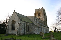
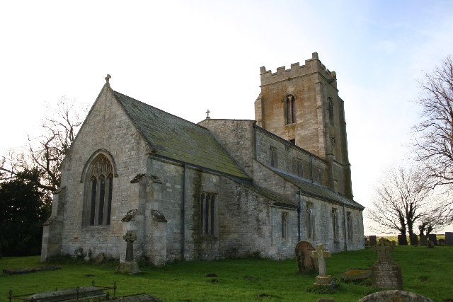
St Andrew's church, Dowsby
 Dowsby
Dowsby shown within LincolnshireOS grid reference TF 11312 29478 District South Kesteven Shire county Lincolnshire Region East Midlands Country England Sovereign state United Kingdom Post town Bourne Postcode district PE10 Police Lincolnshire Fire Lincolnshire Ambulance East Midlands EU Parliament East Midlands UK Parliament Grantham and Stamford List of places: UK • England • Lincolnshire Dowsby is a village and civil parish in the South Kesteven district of Lincolnshire, England. It lies on the western edge of The Fens at the junction of the east-west B1397 road and the north-south B1177. It is 1 mile (1.6 km) north-east of Rippingale and just south of Pointon. The civil parish includes the hamlet of Graby. Nearby to the east, along the B1397, is Car Dyke on Dowsby Fen.[1]
Contents
The Village
52°51′07″N 0°20′56″W / 52.852°N 0.349°W
Dowsby Grade II* listed Anglican parish church is dedicated to St Andrew.[2] The ecclesiastical parish is part of The Billingborough Group of the Deanery of Lafford, Diocese of Lincoln. The incumbent is The Revd John Spreadbury.[3]Dowsby Fen falls within the drainage area of the Black Sluice Internal Drainage Board.[4]
A bus service operates to Bourne on Thursdays, provided by Kimes Buses.
History
The name Dowsby is from the Old Scandinavian Dusi+by, for "farmstead of Dusi", appearing in the Domesday Book as Dusebi.[5]
Although the village looks comparatively modern,[says who?] as though it dates to the Victorian agricultural expansion, it is actually very old.[citation needed]
The Hoe Hills was a group of round barrows dating back to the Bronze Age 52°51′32″N 0°20′37″W / 52.85889°N 0.34361°W where Roman and Medieval finds have been made.[6][7]
St Andrew's church, originating from the 12th century,[2] was mostly rebuilt and enlarged in 1864, although Norman fragments remain as part of the fabric. A recumbent effigy of Etheldreda Rigdon, and six brasses to the Burrell family from 1682 lie in the vestry. Built into the outer wall of the south aisle are parts of a Saxon cross.[8][9]
On the edge of the fen was a decoy used to trap ducks commercially in the 19th century. These would almost certainly have been shipped for sale by railway, probably from Rippingale railway station which was only a mile or so from the decoy.[original research?]
Graby
52°51′13″N 0°21′59″W / 52.85361°N 0.36639°W
Within the parish to the west is the deserted medieval village at Graby,[10] on the line of the Roman Road Mareham Lane.Business
Most of the employment in the parish is agricultural. The former rectory is now a care home for the elderly, providing some employment. The nearest shop is in Billingborough, the nearest pub is in Aslackby
References
- ^ "Car Dyke, Dowsby Fen, Lincs", geograph.org.uk. Retrieved 22 July 2011
- ^ a b "Church of St Andrew", National Heritage List for England, English Heritage. Retrieved 3 July 2011
- ^ "Dowsby PCC". http://www.lincoln.anglican.org/search_parishes.php?22002020.
- ^ "Black Sluice IDB". http://www.blacksluiceidb.gov.uk/.
- ^ Mills, A. D. (1991). A Dictionary of English Place-Names. Oxford University Press.
- ^ "National Monument Record for the Hoe Hills". http://pastscape.english-heritage.org.uk/hob.aspx?hob_id=350993.
- ^ "Hoe Hills:Report on Geophysical Surveys, October 1994 & March 1995.". http://www.eng-h.gov.uk/reports/dowsby/.
- ^ Cox, J. Charles (1916) Lincolnshire p. 118; Methuen & Co. Ltd
- ^ "National Monument Record for the church". http://pastscape.english-heritage.org.uk/hob.aspx?hob_id=350583.
- ^ "National Monument Record for the deserted medieval village at Graby". http://pastscape.english-heritage.org.uk/hob.aspx?hob_id=350651.
External links
Categories:- Villages in Lincolnshire
- Civil parishes in Lincolnshire
- South Kesteven

Wikimedia Foundation. 2010.