- Maatsuyker Islands
-
Maatsuyker Islands 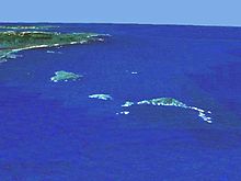
Aerial view of the group from the west. Needle Rocks are on the right. Just to the left of them is Maatsuyker Island. De Witt is the larger island on the left. Tasmania and South East Cape are in the background. View was computer generated from satellite data using NASA World Wind.
Geography Location Off the south coast of Tasmania Total islands 8-12 depending on source Major islands De Witt Island, Maatsuyker Island, Flat Witch Island Country State Tasmania Local Government Area Huon Valley Council Demographics Population Unpopulated 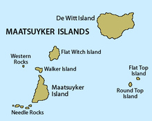 Map of the Maatsuyker Islands
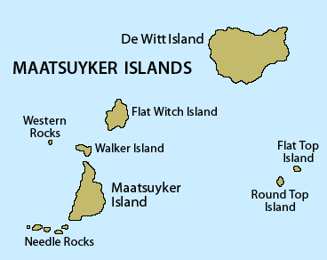
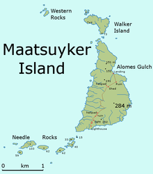 detailed map of Maatsuyker Island
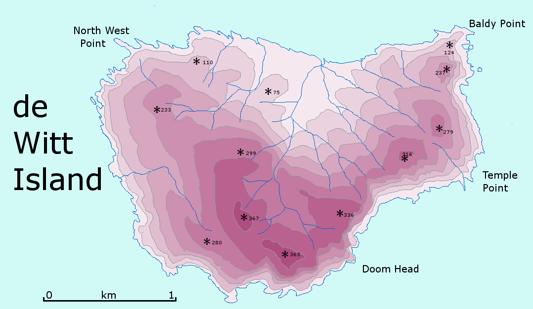
 detailed map of de Witt Island
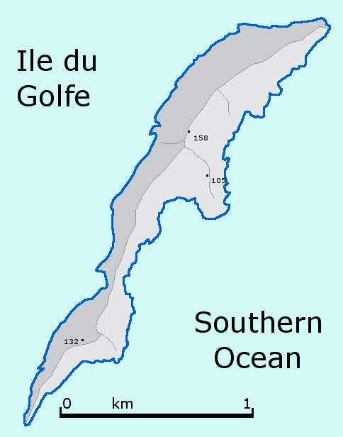
 Outline of Ile du Golfe shaped like a dolphin
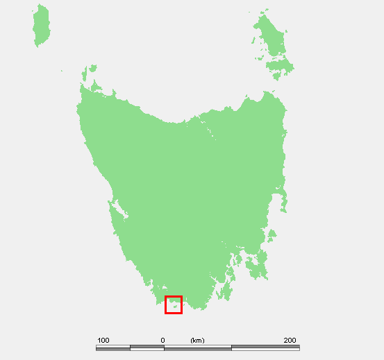
The Maatsuyker Islands Group is a group of islands and rocks located 5.5 kilometres off the south coast of Tasmania. Maatsuyker Island is the southernmost island of the group and of the Australian continental shelf. There are exposed rocks further south of Maatsuyker but they do not meet the definition of "islands". Macquarie Island, far to the south, is also Australian territory but it is an upthrust piece of ocean floor in the remote Southern Ocean and is in a geological sense completely separate from the continent.
The group is noted for its rich marine wildlife, predominantly wet and windy weather conditions, and Australia's most southerly lighthouse. The group is part of the Southwest National Park and thus also part of the Tasmanian Wilderness World Heritage Site.[1]
Contents
Geography
Main Group
The group consists of at least six islands and two groups of rocks.[2] The main island after which the group is named, Maatsuyker Island, is approximately 2.6 kilometres long north/south at its longest on a bearing of 196°, by 1.2 kilometres wide east/west at its widest on a bearing of 105°. Needle Rocks (also known unofficially as The Needles)[3] lie just off the south west tip of Maatsuyker Island. Walker Island, Flat Witch Island and the Western Rocks lie just to the north. De Witt Island lies some 6.5 kilometres to the north-east, and the remaining two islands, Flat Top Island and Round Top Island, are some 7 kilometres to the east. Maatsuyker Island is near the south side of the group, and its distance from the Tasmanian mainland is around 10.4 kilometres.
Sources differ on whether nearby islands are part of the group. Parks and Wildlife Service,[2] includes only the base set above. Brothers[5] includes four extra in an extended group.
The islands are erosional remnants of the Tasmanian mainland, and are typically steep-sided and rocky.
Related Islands
White[6] and Brothers[5] refer to islands in addition to those in the group. These include Breaksea Islands, Eddystone, Kathleen Island, Mewstone, Pedra Branca, Shanks Islands and Trumpeter Islets. Several of these are quite distant from Maatsuyker Island.
History
Origin of the name
Abel Tasman led the first known European expedition to reach Tasmania. His journal[7] records that he first sighted Tasmania on 24 November 1642. The translation of the journal entry for 1 December 1642, seven days later, refers to Wit's islands, Sueers islands, Maetsuickers islands (Maatsuyker Islands) and Boereels islands. The names of all of these islands and Tasmania itself under its then name of Van Diemens Land were all names of then members of the Council of India of Tasman's employer, the Dutch East India Company (see Tasman's 1642 orders in Appendix D of the journal). Antonio Van Diemen was the Governor-General and so got the name of the largest island. This journal entry for 1 December came only 7 days after the first sighting of Tasmania, so it is evident that the Maatsuyker Islands Group was named after Joan Maetsuicker (today's spelling would be Johan), who was also a councillor.
Other theories about the origin of the name have been offered that are more colourful but are fantastical conjectures of a much later period.
- The island was named after a member of Abel Tasman's crew, Mr. Maatsuyker. However, the ship's log book has been preserved and there was not anyone on board with that name.
- It has been suggested that the word in Dutch means "mate seeker" and that the sealers of old stopped at the island seeking aboriginal women as wives. However, "seeker" in Dutch is "zoeker", not "suicker." Nevertheless, there is direct evidence that aborigines visited the island possibly thousands of years before European settlement.[8]
- The word in Dutch means "measure of sugar". This has led some people to suggest - erroneously - that the island, capped with guano, may have resembled a tablespoon of sugar rising above the surface of the sea and that inspired the name.
Given the evidence cited above and the demonstrated fact that Tasman named the other islands in the area after the Councillors, these three anecdotal explanations are - however charming - fantasies.
Lighthouse
Main article: Maatsuyker IslandIn 1891 a lighthouse was completed on Maatsuyker Island and until today it remains Australia's most southerly lighthouse. From the inauguration until the installation of the automated light, the lighthouse was manned by a small staff of lighthouse keepers, who constituted the total population of the island.
Maatsuyker Island Lighthouse was the last Australian lighthouse still being officially operated by lightkeepers. A second, smaller and automated lighthouse was installed in 1996 but it is unclear whether volunteers are going to continue to work the lights on Maatsuyker Island.
Climate
Weather conditions in the area can be extreme, with the Roaring Forties wind being a particular problem. The maximum wind gust ever recorded was 174 km/h.[9] Reportedly, the first keepers of the light took chickens with them to Maatsuyker but the fowls blew away into the ocean. Given the wind and lack of shelter, this is possible if they were left outside during storms. Vegetables get blown flat by the wind, but surprisingly, can be grown successfully,[10] even though the garden is on the west side of the island, facing into the prevailing winds.
To add to the wind, there are an average of 249 rain days a year.[9]
Flora and fauna
Flora
Maatsuyker Island supports a surprising variety of flora and fauna, although the flora is limited in size by the windy conditions. The soil is reportedly extremely rich due to thousands of years of sea bird guano deposits,[10] and supports a variety of native and imported flora. As a testament to fertility, potatoes sown by former lighthouse keepers now grow wild.
Fauna
Seals are common and include both New Zealand and Australian Fur Seals.[11]
The Maatsuyker group is well known for its abundant bird life. Sea birds present include the critically endangered Northern Soft-plumaged Petrel (Pterodroma mollis deceptornis).[12] The first record of Soft-plumaged Petrels breeding in Australia is from Maatsuyker.[13] The group has been identified by BirdLife International as an Important Bird Area (IBA) because it supports over 1% of the world populations of Short-tailed Shearwaters (about 1.5 million pairs), Fairy Prions and Black-faced Cormorants, as well as thousands of pairs of Little Penguins and Common Diving-Petrels. [14]
See also
- South East Cape
- South West Cape
- List of islands of Australia
References
- ^ "Map of the Tasmanian Wilderness WHA". Visitor's Guide. Parks & Wildlife Service Tasmania. Archived from the original on 2007-09-07. http://web.archive.org/web/20070907132410/http://www.parks.tas.gov.au/wha/wherein/detail.html. Retrieved 2009-10-16.
- ^ a b "Small Southern Islands Conservation Management Statement 2002" (PDF). Parks & Wildlife Service Tasmania. 2002. Archived from the original on 2007-08-31. http://web.archive.org/web/20070831033243/http://www.parks.tas.gov.au/IslandCare/southern_islands.pdf. Retrieved 2009-10-16.
- ^ a b "Place Name Search for needle, island, tasmania". Geoscience Australia. http://www.ga.gov.au/bin/gazm01?placename=needle&placetype=M&state=TAS. Retrieved 2006-07-17.
- ^ "Small Southern Islands Conservation Management Statement 2002" (PDF). Parks & Wildlife Service Tasmania. 2002. p. 19. Archived from the original on 2007-08-31. http://web.archive.org/web/20070831033243/http://www.parks.tas.gov.au/IslandCare/southern_islands.pdf. Retrieved 2009-10-16.
- ^ a b Brothers, Nigel; David Pemberton, Helen Pryor, Vanessa Halley (2001). Tasmania's Offshore Islands : seabirds and other natural features. Hobart, Tasmania: Tasmanian Museum and Art Gallery. ISBN 0-7246-4816-X.
- ^ White, Gary. Islands of South-West Tasmania. Sydney: self-published. ISBN 0-9594866-0-7.
- ^ Heeres, J E (Editor) (2006). "Abel Janszoon Tasman's Journal of his Discovery of Van Diemen's Land and New Zealand in 1642 with Documents Relating to his Exploration of Australia in 1644...to which are added his Life and Labours, 1898". Project Gutenberg of Australia. http://gutenberg.net.au/ebooks06/0600571h.html. Retrieved 2006-07-09.
- ^ "Small Southern Islands Conservation Management Statement 2002" (PDF). Parks & Wildlife Service Tasmania. 2002. p. 20. Archived from the original on 2007-08-31. http://web.archive.org/web/20070831033243/http://www.parks.tas.gov.au/IslandCare/southern_islands.pdf. Retrieved 2009-10-16.
- ^ a b "Averages for Maatsuyker Island Lighthouse". Climate Averages for Australian Sites. Bureau of Meteorology. http://www.bom.gov.au/climate/averages/tables/cw_094041_All.shtml. Retrieved 2007-09-07.
- ^ a b "Maatsuyker Garden". Gardening Australia fact sheets. Australian Broadcasting Corporation. http://www.abc.net.au/gardening/stories/s998272.htm. Retrieved 2006-07-12.
- ^ Brothers, N; D Pemberton (1990). "Status of Australian and New-Zealand Fur Seals at Maatsuyker Island, Southwestern Tasmania". Australian Wildlife Research, Volume 17, Number 6. CSIRO Publishing. pp. 563–569. doi:10.1071/WR9900563. http://www.publish.csiro.au/nid/144/paper/WR9900563.htm. Retrieved 2006-07-11.
- ^ Brothers, Nigel; et al.. "RECOVERY OUTLINE Soft-plumaged Petrel (northern)" (PDF). Australian Government Department of the Environment and Heritage. http://www.deh.gov.au/biodiversity/threatened/action/birds2000/pubs/soft-plumaged-p.pdf. Retrieved 2006-07-11.
- ^ Wiltshire, Alan; Sheryl Hamilton, Nigel Brothers (2004-12-16). "First record of Soft-plumaged Petrels, Pterodroma mollis, breeding in Australia". Emu Austral Ornithology, Volume 104, Number 4. CSIRO Publishing. pp. 363–368. doi:10.1071/MU03016. http://www.publish.csiro.au/paper/MU03016.htm. Retrieved 2006-07-11.
- ^ "IBA: Maatsuyker Island Group". Birdata. Birds Australia. http://www.birdata.com.au/iba.vm. Retrieved 2011-08-09.
External links
- "The Maatsuyker Island Lighthouse". Lighthouses of Tasmania. Lighthouses of Australia Inc. http://www.lighthouse.net.au/lights/TAS/Maatsuyker%20Island/Maatsuyker%20Island.htm.
- Report from a trip through the Maatsuyker Islands to Maatsuyker Island
- Second page of the report of the trip to Maatsuyker Island
- Picture of the De Witt Island
- Picture of some of the Maatsuyker Islands
- Another map of the area between South East Cape and South West Cape and the Maatsuyker Islands
- Friends of Maatsuyker Island CARes group
Australian places named by Dutch explorers in the 17th Century1 Queensland Staaten River (Staten Riuier) · Carpentaria

Northern Territory Vanderlin Island (Cap Vanderlin) · Groote Eylandt · Arnhem Land (Arnhems Landt) · Crocodile Islands (Cocodrils Eÿlandt) · Van Diemen Gulf (Baÿa van-Diemen)
Western Australia Houtman Abrolhos2 · Rottnest Island (Eyland Rottenest) · Swan River (Swarte Swaene-Revier)
South Australia St Francis Island (Eyland St. Francois) · St Peter Island (Eyland St. Pierre)
Tasmania Maatsuyker Island (Maetsuickers eylan) · Pedra Branca2 · Storm Bay · Maria Island (Marias Eylandt) · Schouten Island (Schoute Eylandt)
Notes: 1with the name still in use in either original or Anglicised version · 2Named by the Dutch, but a Portuguese name · Many names have been Anglicised; (for these the original Dutch name appears in brackets)
Categories:- Islands of Tasmania
- Protected areas of Tasmania
- South West Tasmania
- Important Bird Areas of Australia


Wikimedia Foundation. 2010.