Needle Rocks

Needle Rocks
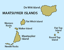
Map of the Maatsuyker Islands
Maatsuyker Island Lighthouse and Needle Rocks

The Needle Rocks, also known as the Needles, are a group of five main rocks with a combined area of about 10.5 ha, in south-eastern Australia. They are part of the Maatsuyker Island Group, lying close to the southern end of the south-western coast of Tasmania. They are part of the Southwest National Park, and thus within the Tasmanian Wilderness World Heritage Site.[1] They are also part of the Maatsuyker Island Group Important Bird Area, identified as such by BirdLife International because of its importance as a breeding site for seabirds.[2]

Fauna

The vegetation is dominated by the succulent plant Pig Face. Recorded breeding seabird and wader species are the Little Penguin (40 pairs), Short-tailed Shearwater (860 pairs), Fairy Prion (10,600 pairs), Pacific Gull, Silver Gull, Sooty Oystercatcher and Black-faced Cormorant. The Metallic Skink is present. Up to 1200 Australian Fur Seals use the rocks as a regular haul-out site.[1]

References

  1. ^ a b Brothers, Nigel; Pemberton, David; Pryor, Helen; & Halley, Vanessa. (2001). Tasmania’s Offshore Islands: seabirds and other natural features. Tasmanian Museum and Art Gallery: Hobart. ISBN 0-7246-4816-X
  2. ^ BirdLife International. (2011). Important Bird Areas factsheet: Maatsuyker Island Group. Downloaded from http://www.birdlife.org on 09/08/2011.

Coordinates: 43°39′45″S 146°15′19″E / 43.6625°S 146.25528°E / -43.6625; 146.25528


Wikimedia Foundation. 2010.

Игры ⚽ Нужно сделать НИР?

Look at other dictionaries:

  • Needle Rocks — Die Needle Rocks im Südwesten von Maatsuyker Island Die Needle Ro …   Deutsch Wikipedia

  • Needle — may refer to: Contents 1 Crafting 2 Botany 3 Geography 4 …   Wikipedia

  • Needle Rock — Needle Rock …   Wikipedia

  • Rivelin Rocks — are a gritstone edge or escarpment that are situated in the upper Rivelin Valley at grid reference gbm4ibx|SK279873, nine kilometres west of Sheffield just off the A57 road in the county of South Yorkshire, England. Overview The rocks reach a… …   Wikipedia

  • Nimbin Rocks — The Nimbin Rocks are volcanic extrusions of rhyolite left over from the Mount Warning Tweed Volcano that erupted around 20 million years ago in what is now northern New South Wales, Australia. As part of an eroded dyke of the volcano, the Rocks… …   Wikipedia

  • Booroomba Rocks — is a granite climbing area in the Australian Capital Territory, particularly noted for its slab climbing. The rocks are divided into several areas, the most prominent being North Buttress, Middle Rocks, and South Buttress.LocationThe cliffs are… …   Wikipedia

  • Maatsuyker Islands — Aerial view of the group from the west. Needle Rocks are on the right. Just to the left of them is Maatsuyker Island. De Witt is the larger island on the left. Tasmania and South East Cape are in the background. View was computer generated from… …   Wikipedia

  • Maatsuyker Island — Der Leuchtturm der Insel, im Hintergrund die Needle Rocks Gewässer Südpazi …   Deutsch Wikipedia

  • Maatsuyker Island Lighthouse — mit den Needle Rocks (links) Das Maatsuyker Island Lighthouse ist der am weitesten südlich liegende Leuchtturm Australiens, der an der südlichen Spitze des Maatsuyker Island liegt. Dieses Bauwerk war auch Australiens letzter bemannter Leuchtturm …   Deutsch Wikipedia

  • De Witt Island — De Witt ist links im Bild vor der Festlandsküste Gewässer Südpazifik …   Deutsch Wikipedia

Share the article and excerpts

Direct link
Do a right-click on the link above
and select “Copy Link”