- Earlwood, New South Wales
Infobox Australian Place | type = suburb
name = Earlwood
city = Sydney
state = nsw
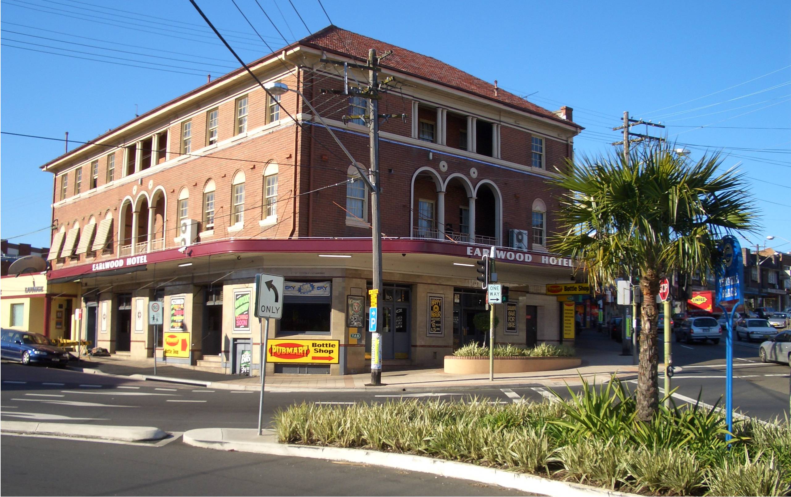
caption = Earlwood Hotel, Homer Street
lga = City of Canterbury
postcode = 2206
pop =
area =
propval =
est =
stategov = Canterbury
fedgov = Watson
near-nw = Hurlstone Park
near-n = Dulwich Hill
near-ne = Marrickville
near-w = Canterbury
near-e = Undercliffe
near-sw = Clemton Park
near-s = Bexley North
near-se = Bardwell Park
dist1 = 12
dir1 = south-west
location1=Sydney CBD Earlwood is a
suburb in south-westernSydney , in the state ofNew South Wales ,Australia . Earlwood is located 12 kilometres south-west of theSydney central business district , in the local government area of the City of Canterbury.Earlwood stretches from the southern bank of the
Cooks River to the northern bank ofWolli Creek . Undercliffe is located to the east. Earlwood is primarily residential with some commercial developments around the main road, Homer Street.History
Earlwood began as a logging camp called Parkes Camp in 1829. As the area was cleared, it became suitable for farming and by 1879 it was known as Parkestown. [ [http://www.canterbury.nsw.gov.au/www/html/1565-canterbury-rates-valuation-book-1879-84----table-2.asp Canterbury Rates Valuation Book-1879-84] ] It was changed to Forest Hill around 1905-06 and changed again to Earlwood in 1918. 'Earl' commemorated a former mayor of Canterbury and 'Wood' was the name of two brothers who owned a pig and poultry farm on Wolli Creek.
Early residents included F. and A. Martin who were granted land in the eastern part and Joshua Thorpe whose 80 acre estate was in the west, stretching from Cooks River to Wolli Creek. Abraham B. Pollack acquired eight grants in the 1830s, totalling convert|790|acre|km2 and covered most of Earlwood and Undercliffe. Subdivision began in the 1880s.
After
World War I , a war services subdivision was created west of Wardell Road for retired soldiers and their families. The streets of that subdivision commemorate the names of famous men and battles connected with the war, such as Kitchener, Hamilton, Vimy, Hamel, Fricourt and Guedecourt. [ "The Book of Sydney Suburbs", Compiled by Frances Pollen, Angus & Robertson Publishers, 1990, Published in Australia ISBN 0-207-14495-8, page 90 ]Between 1912 and 1957, electric trams operated along Homer Street to Earlwood, providing service to the city via Marrickville and Newtown. [D. Keenan: "Tramways of Sydney". Transit Press 1979] The service is now operated by buses.
Commercial area
The shopping centre is located on Homer Street, 500 metres up the hill from Bardwell Park railway station. A Coles supermarket and shops are also located in nearby Clarke Street.
Earlwood has a number of restaurants and cafes are scattered amongst the retail outlets, including several Greek
taverna s. Cafes with outdoor seating are located along Clarke Street, including aMichel's Patisserie . Fast food outlets include aSouvlaki Bar,KFC and Oporto, all located on Homer Street.The Earlwood Hotel is located on the corner of Earlwood Avenue and Homer Street. Earlwood - Bardwell Park RSL is located beside Bardwell Park railway station. Earlwood local library is located on the corner of William Street and Homer Street.
Transport
Earlwood is serviced by a number of
bus routes by Government Bus andPunchbowl Bus Company .Government Bus routes:
* 471 - Rockdale/Five Dock via Bexley, Arncliffe, Canterbury and Ashfield.
* 412 - Campsie/City - King St. Wharf via RPA Hospital and Dulwich Hill (412 Stops At Dulwich Hill Railway Station
* 423 - Kingsgrove/Circular Quay via Newtown
* 499 - Drummoyne/Hurstville via Five Dock, Earlwood, Bexley North
* L23 (PrePay Only) - Kingsgrove to City via NewtownPunchbowl Bus Company routes:
* 446 - Kogarah/Roselands via Bardwell Park
Bardwell Park railway station, on theEast Hills line of theCityRail network, is close to the commercial centre of Earlwood.Churches
Our Lady of Lourdes Catholic Church, St Georges Anglican Church, Earlwood Presbyterian Church,Earlwood Uniting Church, Earlwood Baptist Church, Earlwood Salvation Army, The Transfiguration of Our Lord Greek Orthodox Church.
Parks and gardens
* Heynes Reserve is a passive recreation area at the junction of the Cooks River and
Cup and Saucer Creek .
* Sutton Reserve is adjacent to Heynes Reserve. It features a playground and is connected to the northern bank of the Cooks River by a wooden footbridge.
* Hughes Park is a sporting and multi-use ground located near the Belmore border and runs along a pipeline leading to the Cooks River
* Simpson Reserve is further west along the Cooks River. Beaman Park and Wills Ground are located further east along the river.
*Earlwood Oval is a local soccer and sporting ground
* Girrawheen Park is a large recreational area along the northern bank of Wolli Creek. It provides spectacular views of Arncliffe, Turrella and Bardwell Park.Population
Demographics
Earlwood is a multicultural area, with a large proportion of
Greek-Australian s. Nearby Marrickville was a major centre of Sydney's Greek community in the 1950s and 1960s and many of its residents began moving south into suburbs like Earlwood, which offered larger family homes and blocks of land.The 2006 Census of Population and Housing recorded 16,497 people living in Earlwood. 34.3% of the population come from a non English speaking background and 9.2% are from a Greek background.
Notable residents
The following notable people have lived in Earlwood:
* Former Prime MinisterJohn Howard
* ActorGrahame Bond (The Aunty Jack Show )
* ActorAlex Dimitriades
* BoxersAnthony Mundine andTony Mundine
* FormerSocceroos Johnny Warren andPeter Katholos
*NSW Attorney General John Hatzistergos
* FormerPanathinaikos andOlympiacos football (soccer) playerChris Kalantzis
* FormerNewtown andAustralian Rugby League playerDick Poole
*Dance Music Producer/Model-Adrian Bruno
* Former Rugby League player and refereeJack Danzey Politics
Federal Government: Earlwood is in the
Division of Watson in theAustralian House of Representatives .Historically, theDivision of Watson has been a safe Labour electorate.State Government: Earlwood is in the
Electoral district of Canterbury in theNew South Wales Legislative Assembly . The district includes surrounding suburbs of Canterbury, Campsie, Hurlstone Park, Croydon Park, western Dulwich Hill, eastern Belfield and northern Turrella.Local Government: Earlwood is part of the East Ward of the City of Canterbury and together with Canterbury, elects three councillors to the city council.
References
External links
* [http://www.canterbury.nsw.gov.au/www/html/864-history-of-earlwood.asp Canterbury City Council - History of Earlwood]
* [http://www.immigration2australia.com/living_australian_culture_greek_immigration_australia.html/ Greek Immigration to Australia]
Wikimedia Foundation. 2010.