- Mount Airy, Philadelphia, Pennsylvania
-
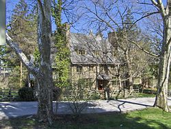 Stone cottage in Mount Airy, Philadelphia. The community is known for its elegant examples of 18th and 19th century residential architecture.
- For other uses, see Mount Airy.
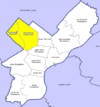
Mount Airy is a neighborhood of Northwest Philadelphia in the state of Pennsylvania.
Contents
Geography
Boundaries
Mount Airy is bounded on the northwest by the Cresheim Valley, which is part of Fairmount Park. Beyond this lies Chestnut Hill. On the west side is the Wissahickon Gorge, which is also part of Fairmount Park, beyond which lies Roxborough and Manayunk. Germantown borders the southeast of Mount Airy, and Stenton Avenue marks the northeast border. Beyond Stenton Avenue is Cedarbrook and West Oak Lane.
ZIP codes
The USPS does not officially correlate neighborhood names to Philadelphia ZIP codes (all are called simply "Philadelphia" or "Phila").[1] However, the 19119 ZIP code is almost entirely coterminous with the cultural-consensus boundaries of Mount Airy.
Relationship to Germantown
There is no "official" boundary between Mount Airy and Germantown. The most common consensus is that Johnson Street is the de facto boundary; however, Washington Lane could also be viewed as a boundary. The question is moot, however, as the two neighborhoods blend together very gradually. Historically, the entire area was part of the German Township. Many buildings in Mount Airy carry the identity and even the name of Germantown in one way or another. For example, the Unitarian Church of Germantown, the Germantown Jewish Center, the Germantown Christian Assembly, and the Germantown Montessori School are all in Mount Airy, yet also belong culturally to Germantown. Parts of the Battle of Germantown in 1777 occurred throughout Mount Airy. The special relationship linking the two has its roots in the time before the Act of Consolidation, when Germantown was a borough separate from the City of Philadelphia, and its rural environs were what is now Mount Airy.
History
William Allen, a prominent Philadelphia merchant and Chief Justice of the Province of Pennsylvania, created his summer estate and mansion on Germantown Avenue at Allens Lane in 1750, and the area eventually took the building's name, Mount Airy, as its own.[2] Before this, the area which makes up the modern neighborhood of Mount Airy was part of two sections of the original Germantown Township (which covered all of Germantown, Mount Airy, and Chestnut Hill), Cresheim and Beggarstown.
The village or Dorfshaft of Krisheim (also known as Cresheim) has its origins in the original land divisions of Germantown Township in 1689.[3] It was a section of the township that was allotted to a group of original Germantown settlers who acquired rights to land either directly or indirectly from William Penn. It covered the area from Stenton to Wissahickon Avenues and from Mermaid Lane to roughly Sedgwick Street. The name is derived from a town known today as Kriegsheim in the Palatine in Germany which was the hometown of a few German Quaker families who had settled in Germantown in the 1680s. Throughout much of the 18th century, this area of Germantown Township was known in the land and tax records as simply Cresheim or Cresham. It was at the beginning of the 19th century that the name Mount Airy began to replace Cresheim.[4]
Beggarstown (also Beggars-town or Beggar Town), an area centered along Germantown Avenue between Gorgas Lane and Cliveden Street, was formed out of the so-called "Sidelands" of Germantown. The Sidelands were a section of Germantown Township that had been set aside so that the owners of lots in the center of Germantown could have access to an equal share of land in the entire village of Germantown section of Germantown Township. The portion from which Beggarstown grew covered the area from Upsal Street to roughly Sedgwick Street, Stenton Avenue, and Wissahickon Avenue. As the Germantown village filled up, settlers began to move northwest along Germantown Avenue. By the 1730s and 1740s, the Sidelands area was subdivided into smaller house lots. An account published in 1770 states that the area received its name as a result of its first resident's begging for money to build his house, which later became the home of the Germantown Church of the Brethren. The name for this area disappeared by the late 19th century, and it was sometimes called Pelham, Germantown, or Mount Airy.
Much of modern Mount Airy was developed in the late 19th and early 20th centuries, spreading out from Germantown Avenue and two railroad lines. Large three-story, gray-stone Victorian, colonial revival, and Norman and Cotswold-style houses and mansions, with stained glass windows and slate roofs, are situated on many of the area's tree-lined streets. They dominated districts like West Mount Airy's Pelham section (a Wendell and Smith development from 1890s), East Mount Airy's Gowen Avenue (the James Gowen Estate development from 1880s), Sedgwick Farms (an Ashton S. Tourison development from 1905), and Stenton (a Frank Mauran development from 1905) areas.
Demographics
As of the 2010 Census,[5] Mount Airy has 27,035 residents, 11,934 households, and 6,636 families. 62.5% of residents are Black or African-American, 31.7% White/Caucasian, and 5.8% are from other races or from 2 or more races.
There are 11,934 households out of which 22.9% have children under the age of 18 living with them, 33.1% are married couples living together, 18.3% have a female householder with no husband present, and 44.4% are non-families. 37.3% of all households are made up of individuals and 27.7% have someone living alone who is 65 years of age or older. The average household size is 2.21 and the average family size is 2.92.
20.1% of Mount Airy’s residents are under the age of 18, and 16.9% are 65 years and over. The median age is 42.7 years. 56.5% of residents are female. For every 100 females age 18 and over, there are 72.8 males.
As of 1999, the median household income was $46,520, the median family income was $58,297 and the per capita income was $28,287.[6] 2010 Census Economics Characteristics data for zip code 19119 has not yet been released.
Racial integration
The area is recognized by many civil rights groups as one of the first successfully integrated neighborhoods in America.[7][8] Mount Airy residents organized to resist blockbusting, panic selling, and redlining, especially during the period from the late 1950s to the early 1970s when those practices were prevalent.[9][10] It continues to be a well-blended neighborhood and was recently cited in Oprah Winfrey's O magazine for its racial diversity and neighborhood appeal. The community has also been recognized by US News & World Report for racial harmony and balance.[11]
Other demographic facets
Mount Airy has a significant number of lesbian households.[12] It has been called a "Ph.D. ghetto" because many residents have advanced degrees.[8] The political tone of the neighborhood is predominantly liberal.[13] Mount Airy is favored as a neighborhood of choice for city politicians, judges, and others who are required to reside within the city's limits.[citation needed] One prominent Mount Airy politician is former Republican mayoral candidate Sam Katz.
There is a large Jewish community in Mount Airy, with significant institutional presence including three congregations and three national offices of Jewish organizations. The congregations are: Germantown Jewish Centre, P'nai Or Jewish Renewal Congregation of Philadelphia, and Chabad-Lubovitch of Northwest Philadelphia. The three national organizations are: Aleph, Alliance for Jewish Renewal, the National Havurah Committee, and The Shalom Center. Though these congregations and institutions show the vitality of Mt. Airy's continued Jewish presence, the number of congregations and people were far higher in the early 1960s when the center of the Jewish population in the area was East Mt. Airy.
Mount Airy has long been a neighborhood of choice for many of the city's prosperous African Americans.[8]
A Hare Krishna community is located on West Allens Lane.
West Mount Airy has a reputation for being affluent, similar to Chestnut Hill, and the East more working class, although counter-examples abound.[8] In general, the affluence of the neighborhood increases with proximity to Fairmount Park and Chestnut Hill.
Education
Primary and secondary schools
Public schools
The School District of Philadelphia operates area public schools. Zoned K-5 schools serving sections of Mt. Airy include the Eleanor C. Emlen School. Zoned K-8 schools serving sections of Mt. Airy include Charles W. Henry School, Henry H. Houston School, and the Anna L. Lingelbach School.[14] Residents assigned to Henry, Houston, and/or Lingelbach are also zoned to Germantown High School.[15] Other nearby schools include Academy for the Middle Years, Parkway High School, and Martin Luther King High School.[14]
West Oak Lane Charter School and Wissahickon Charter School are two Mt. Airy area K-8 charter schools. Charter schools in nearby Germantown include Imani Education Circle Charter School (K-8), Germantown Settlement Charter School (5-8), Renaissance Charter School (6-8), and Delaware Valley Charter High School (9-12).[14]
Private schools
Private schools in Mount Airy include the Green Tree School (ages 6–21), Blair Christian Academy (PreK-12), Revival Hill Christian High School (9-12), Islamic Day School of Philadelphia (PreK-5), Waldorf School of Philadelphia (PreK-8), Project Learn School (K-8), Classroom on Carpenter Lane (K-2), and Holy Cross School (K-8), a parochial school. Private schools in nearby Germantown include Germantown Friends School (K-12), William Penn Charter School (K-12), Ivy Leaf School (PreK-4), Greene Street Friends (K-8), Pennsylvania School for the Deaf (ages 3–17), and St. Barnabas Episcopal School (K-6). Chestnut Hill Academy (K-12), Springside School (PreK-12), and Crefeld School (7-12) are in nearby Chestnut Hill. The Miquon School (K-6) is in Borough of Conshohocken.[14] St. Martin De Porres Interparocial (1-8) is in nearby Germantown.[14]
Colleges and universities
Universities and colleges close to Mount Airy include Arcadia University, Chestnut Hill College, La Salle University, The Lutheran Theological Seminary at Philadelphia, Philadelphia University, and St. Joseph’s University.[14]
Public libraries
Free Library of Philadelphia operates the Lovett Square Branch at 6945 Germantown Avenue.[16]
Transportation
A commute to Center City is approximately a twenty minute drive without heavy traffic.[17] The large suburban shopping and office districts around King of Prussia, Plymouth Meeting, and Conshohocken are also within about a fifteen to twenty-five minute drive of Mount Airy.[18][19] Mount Airy is also served by public transportation. Two SEPTA Regional Rail lines connect the neighborhood to Center City. The Chestnut Hill West Line runs through West Mount Airy with stops at Allen Lane, Carpenter and Upsal stations, and the Chestnut Hill East Line through East Mount Airy with stops at Mount Airy, Sedgwick and Stenton stations—Washington Lane station is in Germantown across the street from Mount Airy. The neighborhood is also served by bus routes 18, 23 (formerly a trolley line), 53 (formerly a trolley line), H, and L.[citation needed]
Shopping
Mount Airy's main commercial district lies along cobblestoned Germantown Avenue, which also serves as the boundary between East and West Mount Airy. The neighborhood has a variety of independent shops, restaurants, art galleries, clothing stores, coffee shops, a gastropub, wine bar, and professional offices. In 2011, the New York Times described the influx of new businesses to Mount Airy as a "cultural revival" buoyed by "the neighborhood's reasonable housing costs and relatively safe streets."[13] Its shopping district along "The Ave" gives it a small-town feel, although there are also a few chain stores such as an Acme Supermarket and a Wawa. Mount Airy is also home to Weavers Way Co-op, a long-running co-op grocery store, and two local, tented farmers' markets.[20] It has two independent bookstores: Big Blue Marble Bookstore, with new titles catering to neighbors' interests; and Walk a Crooked Mile Books, a large used-book store housed in the Mount Airy train station. West Mount Airy has a small commercial district of its own centered around Greene Street and Carpenter Lane, whereas East Mount Airy has more diffuse commercial districts along Stenton and Chew Avenues.
A number of commercial properties in Mount Airy have recently received economic development grants and façade rehabilitation assistance from Mount Airy USA, a neighborhood non-profit community economic development organization.
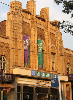
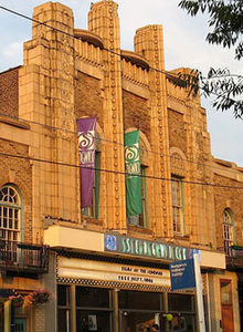 The Sedgwick Theater in Mount Airy, a 1920s Art Deco movie theatre
Notable residents
- Sadie Tanner Mossell Alexander, first African American woman Ph.D. from University of Pennsylvania; Truman administration official
- Mark Baltin, linguist, professor of Linguistics at New York University
- Eric Bazilian, musician
- Jesse Biddle, baseball player
- Sandra Boynton, cartoonist and children's book author
- Dan Bricklin, inventor and entrepreneur
- Charles Darrow, a developer of the game Monopoly
- Elizabeth Shippen Green, artist and illustrator
- A. Leon Higginbotham, Jr.,the first African American judge on the United States District Court for the Eastern District of Pennsylvania
- Amy Ignatow, author and illustrator of The Popularity Papers series
- Khan Jamal, Jazz musician
- Mat Johnson, author and playwright
- Connie Mack, baseball manager and owner
- John McWhorter, linguist and conservative intellectual
- Violet Oakley, artist
- Saul Perlmutter, Nobel Prize-winning astrophysicist[21]
- Kurt Rosenwinkel, jazz guitarist
- Zalman Schachter-Shalomi, Jewish religious leader
- Brianna Taylor, Reality TV Star from The Real World Hollywood
- Paul F. Tompkins, Comedian, TV Host, and Podcaster
- Dr. C. DeLores Tucker, civil rights activist; first black female Secretary of State of a U.S. state in the nation; fought against music lyrics demeaning to African Americans and women
- Robert Venturi, architect
- Grover Washington Jr. Jazz musician
- Jessie Willcox Smith, illustrator and artist
Notable institutions
- The Lutheran Theological Seminary at Philadelphia (LTSP) is located at Germantown Ave. and Allen's Lane. The seminary is associated with the Evangelical Lutheran Church in America, the largest Lutheran denomination in the U.S., and also serves as its Region 7 headquarters.
- The Sedgwick Theater, a 1920s Art Deco movie theater, is one of the few remaining in Philadelphia.
- Mount Airy is home to numerous properties listed on the National Register of Historic Places as well as sharing the Colonial Germantown Historic District with neighboring Germantown.
See also
External links
- Aleph Alliance for Jewish Renewal
- Chabad-Lubovitch of Northwest Philadelphia
- East Mount Airy Neighbors
- Films at the Sedgwick
- Germantown Jewish Centre
- Lutheran Theological Seminary at Philadelphia
- Mount Airy Business Association
- New Covenant Church and Campus
- Mt. Airy Historical Awareness Committee, Mount Airy Bibliography, 4th Edition, 2004
- Mt. Airy USA
- National Havurah Committee
- P'nai Or Jewish Renewal Congregation of Philadelphia
- The Shalom Center
- West Mount Airy Neighbors
References
- ^ USPS "Find All Cities in a ZIP Code".
- ^ "Philadelphia Neighborhoods and Place Names, L-P". http://www.phila.gov/phils/Docs/otherinfo/pname2.htm. Retrieved 2006-11-06.
- ^ Francis Daniel Pastorius' "Ansprach and die Nachkömmlingschaft" in the Germantown "Grund und Lager Buch" transcribed and translated on pp. 268-74 in Learned, Marion F. (1908). The Life of Francis Daniel Pastorius. Philadelphia. http://books.google.com/?id=20sOAAAAIAAJ&pg=PA1&dq=pastorius. Retrieved 2007-09-28. and another account that appears in the "Grund und Lager Buch" translated by Learned on p. 137.
- ^ The Philadelphia newspapers refer to the area as "near Mount Airy College" around 1815 (Ad for residence "in the immediate neighborhood of Mount Airy College" The American Daily Advertiser. 1817-04-19.) or simply "Mount Airy" around 1820 (Marriage notice for "Miss Ann Gorgas, of Mount Airy, Germantown" The American Daily Advertiser. 1818-02-17.).
- ^ Year 2010 Census Data for 19119
- ^ Year 2000 Census Data for 19119
- ^ Leonard Franklin Heumann: The Definition and Analysis of Stable Racial Integration
- ^ a b c d "Racially and Ethnically Diverse Urban Neighborhoods, Cityscape, Volume 4, Number 2, 1998. Chapter 3, by Barbara Ferman, Theresa Singleton, and Don DeMarco". http://www.huduser.org/periodicals/cityscpe/vol4num2/ch3.html.
- ^ Gordy, John H. “Mt. Airy Group Drafts Code of Ethics for Homes Sales.” Philadelphia Evening Bulletin, 18 February 1959.
- ^ Smyth, Jack. “Panic-Selling Fought in Mt. Airy, W. Oak Lane: 29 Realty Firms Agree to Anti-Bias Code.” Philadelphia Evening Bulletin, 10 February 1966.
- ^ Buckley, Jerry. "Mt. Airy, Philadelphia." U. S. News and World Report, 22 July 1991, 22–28.
- ^ ""The Philadelphia LGBT Community Assessment Final Report, October 27, 2006"". http://www.dvlf.org/newsite/documents/Philadelphia-LGBT-Assessment-final-version-April-2007.pdf.
- ^ a b Zach Pontz (June 5, 2011). "Enclave Embraces Brotherly Love". The New York Times: Section Travel. http://www.nytimes.com/slideshow/2011/06/05/travel/20110602-SURFACING.html. Retrieved June 9, 2011.
- ^ a b c d e f "Education." Mt. Airy USA. Retrieved on January 20, 2009.
- ^ "A Directory of High Schools for 2009 Admissions." School District of Philadelphia. Retrieved on January 20, 2009.
- ^ "Lovett Branch." Free Library of Philadelphia. Retrieved on November 7, 2008.
- ^ "Driving directions from Mt Airy's Germantown Avenue main business district to Center City including estimated trip time.Google Maps. Retrieved on February 2, 2011". http://maps.google.com/maps?f=d&source=s_d&saddr=W+Mt+Pleasant+Ave&daddr=40.0538,-75.19339+to:40.0240872,-75.1956233+to:N+15th+St&geocode=FQs-YwIdHLOE-w%3BFSgsYwId0qOE-ykFmb-NpbnGiTFdRRqN5AMSVQ%3BFRe4YgIdGZuE-ykzg-DOXbjGiTHZ1Cy5sGyOmg%3BFV6sYQIdDBSF-w&gl=us&hl=en&mra=ltm&via=1,2&sll=40.007106,-75.174465&sspn=0.185264,0.114841&ie=UTF8&ll=40.007106,-75.18631&spn=0.185264,0.114841&z=13.
- ^ "Driving directions from Mt Airy's Germantown Avenue main business district to Plymouth Meeting Metroplex Center including estimated trip time.Google Maps. Retrieved on February 3, 2011". http://maps.google.com/maps?f=d&source=s_d&saddr=W+Mt+Pleasant+Ave&daddr=Route+476&geocode=FQs-YwIdHLOE-w%3BFfbsYwId0SGD-w&gl=us&hl=en&mra=mift&mrsp=1&sz=14&sll=40.085492,-75.280981&sspn=0.090621,0.057421&ie=UTF8&ll=40.085492,-75.297375&spn=0.090621,0.090122&z=14.
- ^ "Driving directions from Mt Airy's Germantown Avenue main business district to King of Prussia Mall including estimated trip time.Google Maps. Retrieved on February 3, 2011". http://maps.google.com/maps?f=d&source=s_d&saddr=W+Mt+Pleasant+Ave&daddr=Mall+Boulevard,+King+of+Prussia,+PA&geocode=FQs-YwIdHLOE-w%3BFU68YwIdNZmB-yn1jFsFSpTGiTFR2S-7o6eqXw&gl=us&hl=en&mra=ls&sll=40.153162,-75.221672&sspn=0.181063,0.114841&ie=UTF8&z=12.
- ^ Laura Bruch, "Weavers Way Thriving," Philadelphia Inquirer, 16 October 1998, http://www.farmtocity.org/FarmersMarkets.asp
- ^ http://articles.philly.com/2011-10-04/news/30242928_1_astrophysicist-adam-riess-elementary-grades
Coordinates: 40°03′58″N 75°11′5″W / 40.06611°N 75.18472°W
Neighborhoods of the Northwest Philadelphia section of Philadelphia, Pennsylvania Andorra • Beggarstown • Chestnut Hill • East Falls • Germantown • Manayunk • Morton • Mount Airy • Roxborough • Wissahickon • Wister
 Categories:
- Neighborhoods in Philadelphia, Pennsylvania


Wikimedia Foundation. 2010.