- Cresheim Creek
-
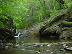 Cresheim Creek before it meets Wissahickon Creek.
Cresheim Creek is a creek in southeastern Pennsylvania. Rising at Hill Crest in Cheltenham Township (near the border between Montgomery County and Northwest Philadelphia at Holy Sepulchre Cemetery), it runs about 2.7 miles (4.3 km) southwest, passing through part of Northwest Philadelphia and dividing Mount Airy from Chestnut Hill, before emptying into the Wissahickon Creek at Devil's Pool not far south of the Valley Green Inn.
The Cresheim Valley is part of Fairmount Park. The former railbed within it is also an easement for PECO powerlines, which take advantage of the former railbed's grading and open space.
Cresheim Valley Drive runs beside the creek from Stenton Avenue until southwest of the tracks, where it bends away to become Emlen Street. The stone pergola that stands at the southwest corner of the intersection of Germantown Avenue and Cresheim Valley Drive contains plaques honoring both the early German settlers of the Cresheim Valley and Samuel Newman Baxter, chief arborist of Fairmount Park from 1915 to 1945.
Contents
History
Pre-Euro-American and early-Euro-American periods
The area around Cresheim Creek was originally inhabited by the Lenape. 17th-century(1600s) settlers of the German Township named the creek after the village from which they had emigrated (which is now part of Monsheim, Alzey-Worms, Rhineland-Palatinate). The aforementioned pergola plaque gives the settlers' spelling of the name as Krisheim. The settlers arrived in the 1680s. In 1700, they built Cresheim Cottage, the earliest permanent building in the vicinity, which is still standing at the intersection of Germantown Avenue and Gowen Avenue. (It's the smaller part of the present building; the larger part was built circa 1748.)
Cresheim Branch (Fort Washington Branch) of the Connecting Railway
From 1893 to 1953, a branch of the Connecting Railway, variously called the Cresheim Branch or Fort Washington Branch, diverged from the Chestnut Hill Branch (present-day Chestnut Hill West Line) just north of Allen Lane station (behind what is now the campus of New Covenant Church and several schools) and ran next to the creek's bank from there to the creek's headwaters at Hill Crest (near Holy Sepulchre Cemetery). (Incidentally, the headwaters of Tookany Creek flow from this same hill eastward.) From Hill Crest, the railbed curved through Laverock to meet and follow the right-of-way that is now occupied by the Fort Washington Expressway portion of Route 309 to Fort Hill, near Fort Washington, where it connected with the Trenton Cut-Off.
Outdoor enthusiasts of Northwest Philadelphia and various Montgomery County communities have encouraged their local legislators to effect the conversion of the Cresheim Branch's railbed into a rail trail.[1],[2]
See also
References
- ^ "The Cresheim Trail Project, a non-profit, volunteer, community initiative (cresheim.org).". http://www.cresheim.org/. Retrieved 2007-06-04.
- ^ Riley, Paula M. (2006-06-01). "Carl Shaifer: improving quality of life for Hillers". Chestnut Hill Local. http://www.chestnuthilllocal.com/issues/2006.06.01/locallife2.html. Retrieved 2007-06-04.
Categories:- Rivers of Pennsylvania
- Schuylkill River

Wikimedia Foundation. 2010.