- Miller, New South Wales
-
Miller
Sydney, New South Wales
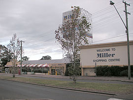
Miller Shopping CentrePopulation: 3000 (2006) Established: 1965 Postcode: 2168 Location: 38 km (24 mi) south-west of Sydney CBD LGA: City of Liverpool State District: Liverpool Federal Division: Fowler Suburbs around Miller: Hinchinbrook Busby Busby Hinchinbrook Miller Sadleir Hoxton Park Prestons Cartwright Miller is a suburb of Sydney in the state of New South Wales, Australia. Miller is located 38 kilometres south-west of the Sydney central business district, in the local government area of the City of Liverpool.
Contents
Commercial area
Miller Shopping Centre is currently managed by Savills (NSW) Pty Ltd. It is a community shopping centre featuring Woolworths, Franklins and approximately 32 other specialty shops. Miller Shopping Centre was sold to new owners in early 2011 and plans are currently in place for renovtions to commence to improve its appeal and status in the community.
History
Miller was part of the Green Valley housing estate which was developed between 1961 and 1965. It was named after Peter Miller, an early landholder in the Green Valley area.[1]
Schools
- Miller Technology High School contains an English-language program for immigrant children from the entire Liverpool council area.[2]
- Miller Public School[3]
Population
According to the 2006 census, Miller had a population of 2998. While the majority of the population spoke English only at home, there were substantial numbers speaking Arabic (14.5%), Vietnamese (7.3), Hindi (2.6%), Spanish (2.3%) and Samoan (1.7%). It is a low-income area with the median household income ($498 per week) less than half the national average ($1027) and large number of properties in the area (470 out of 1200) are owned by the Housing Commission.[4]
References
- ^ The Book of Sydney Suburbs, Compiled by Frances Pollen, Angus & Robertson Publishers, 1990, Published in Australia ISBN 0-207-14495-8
- ^ "Miller Technology High School". NSW Department of Education. http://www.miller-h.schools.nsw.edu.au/. Retrieved 2008-07-07.
- ^ "Miller Public School". NSW Department of Education. http://www.miller-p.schools.nsw.edu.au/. Retrieved 2008-07-07.
- ^ Australian Bureau of Statistics (25 October 2007). "Miller (State Suburb)". 2006 Census QuickStats. http://www.censusdata.abs.gov.au/ABSNavigation/prenav/LocationSearch?collection=Census&period=2006&areacode=SSC11657&producttype=QuickStats&breadcrumb=PL&action=401. Retrieved 2008-07-07.
External links
- Miller, New South Wales is at coordinates 33°55′36″S 150°52′21″E / 33.92679°S 150.87240°ECoordinates: 33°55′36″S 150°52′21″E / 33.92679°S 150.87240°E
Suburbs and localities within the City of Liverpool | South-western Sydney | Sydney Ashcroft · Austral · Badgerys Creek* · Bringelly* · Busby · Carnes Hill · Cartwright · Casula · Cecil Hills · Cecil Park* · Chipping Norton · Denham Court · Edmondson Park · Green Valley · Greendale · Hammondville · Heckenberg · Hinchinbrook · Holsworthy · Horningsea Park · Hoxton Park · Ingleburn · Kemps Creek* · Leppington* · Liverpool · Luddenham* · Lurnea · Middleton Grange · Miller · Moorebank · Pleasure Point · Prestons · Rossmore* · Sadleir · Voyager Point · Wallacia* · Warwick Farm · Wattle Grove · West Hoxton
List of Sydney suburbs Categories:- Suburbs of Sydney
- Sydney geography stubs
Wikimedia Foundation. 2010.
