- Portal:Michigan Highways
-
Portals → Technology → Transport → Roads → U.S. Roads → Michigan Highways Michigan Highways
The Michigan State Trunkline Highway System of the US state of Michigan is a network of roads owned and maintained by the Michigan Department of Transportation (MDOT). The most prominent of these roads are part of one of three numbered highway systems in Michigan, Interstates US Highways and the other State Trunklines. Other systems of roads are operated by the 83 counties in the state as well as each city.


Interstate Highways and US Highways are assigned at the national level. Interstate Highways are numbered in a grid—even-numbered routes are east–west routes (but the lowest numbers are along Mexico and the Gulf of Mexico), and odd-numbered routes are north–south routes (with the lowest numbers along the Pacific Ocean). US Highways are also numbered in a grid—even numbered for east–west routes (with the lowest numbers along Canada) and odd numbered for north–south routes (with the lowest numbers along the Atlantic Ocean). For this reason, mainline (two-digit) Interstate Highways in Michigan all have numbers above 69 and mainline US Highways all have numbers below 45. Three-digit Interstate and U.S. Highways, also known as "child routes," are branches off their main one- or two-digit "parents". The Interstate and US Highways are maintained by MDOT. Interstate 75 (I-75) and US Highway 23 (US 23) are the longest examples in the state.


State Trunklines are the other state highways maintained by MDOT. These highways are completely owned and maintained by the state. Michigan highways are properly referred to using the M and never as "Route 28" or "Highway 28", but as M-28. The marker used for state trunklines is a diamond with a block-letter "M" at the top. Roads that are maintained by the state but not assigned a state trunkline designation carry an unsigned highway designation.


County-Designated Highways are assigned numbers in a zone system by MDOT, but maintained by the counties. Each county also maintains any other roadway that is not a state trunkline or a city street. The numbering and signing practices vary from county to county, as does the size of each county's system. Numerical designations typically do not carry over from one county to the next; a CDH that crosses county lines keeps its designation in each county however.
Selected article
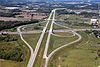
M-6, or the Paul B. Henry Freeway, is a 19.696-mile (31.698 km) freeway that serves portions of southern Kent and eastern Ottawa counties south of Grand Rapids. The freeway is named for Paul B. Henry, a congressman who died in office representing the area. The freeway connects Interstate 196 (I-196) on the west to I-96 on the east while running through the south side of the Grand Rapids metropolitan area in Western Michigan. Each end is in a rural area while the central section has suburban development along the freeway near the connection to US Highway 131.
The freeway was originally conceived in the 1960s. It took 32 years to plan, finance, and build the freeway from the time that the state first authorized funding in 1972 until the South Beltline opened to traffic in November 2004. Initial construction started in November 1997, with the first phase opened in November 2001. The first phase of construction was completed in asphalt, while the second and third phases were built in concrete, costing a total of $700 million. The project was built with two firsts: the first single-point urban interchange in Michigan, and a new technique to apply the pavement markings, embedding them into the concrete to reduce the chance of a snowplow scraping them off. (more...)
Recently selected: Brockway Mountain Drive • US 41 • Capitol Loop
Selected picture
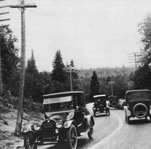
Marquette–Negaunee Road along Dead Man's Curve in 1917 with the first highway centerline in the country Recently selected: Capitol Loop • M-39 • M-28/M-64
Did you know...
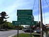
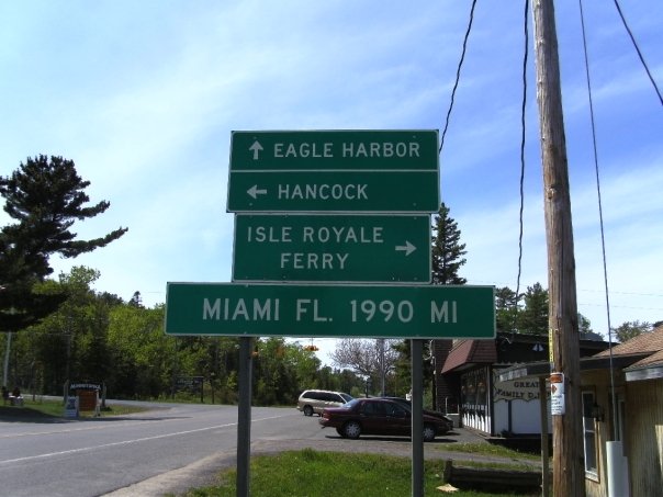
- ... that there is a mileage sign (pictured) on US 41 in Copper Harbor that proclaims that it is 1,990 miles (3,200 km) to Miami?
- ... that in 1919, Michigan was the second state to sign numbered highways after Wisconsin?
- ... that M-68 was a discontinuous highway in Northern Michigan between 1940 and 1946?
- ... that Westnedge Avenue and Park Street south of downtown Kalamazoo are part of M-331, an unsigned highway?
- ... that cars are forbidden from Mackinac Island, making M-185 the only state highway without them?
Categories
Topics
State Trunkline System, overview of the system
-
- Interstates Highways in the state
- US Highways in the state
- State Trunklines
-
- County-Designated Highways in the state
- Michigan Heritage Routes, a system of scenic, historical or recreational highways in the state
- Great Lakes Circle Tour
Related portals


Michigan Metro Detroit U.S. Roads 


Canada Roads New York Roads Washington Roads WikiProjects
- U.S. Roads Wikiproject
- Michigan Wikiproject
- Detroit Task Force
- Michigan State Highways Project
- Michigan County-Designated Highways Task Force
Things to do
Nominations and votes for selected articles and selected pictures are always needed. Anyone can nominate an article, and anyone can vote for an article. You can also recommend items for Did you know?. Improvements to the articles are always welcome as the project works on expanding and nominating the remaining ones for Good Article or Featured Article status.
Categories:- Transport portals
- United States portals


Wikimedia Foundation. 2010.