- Oyapock
-
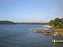

The Oyapock or Oiapoque River (French: Fleuve Oyapock; Portuguese: Rio Oiapoque) is a 370-km (230-mi) long river in South America that forms most of the border between French Guiana and the Brazilian state of Amapá. It rises in the Tumuk Humak (Portuguese: Tumucumaque) mountain range and flows into the Atlantic Ocean, where its estuary forms a large bay bordering on Cape Orange.
Vicente Yáñez Pinzón was said to be the first European person to see the Oiapoque River in the first years of the 16th century. It has been called Japoc, Yapoc, Iapoco, and even Vicente Pinzón River. Early European colonists referred to the river as the Wiapoco, and it was the site of early settlements by Briton Robert Harcourt in 1608 and Dutchman Jan van Ryen in 1627. The name Oiapoque has been officially used from 1900, when a territorial dispute between Brazil and France was resolved through Swiss diplomatic arbitration.
False northernmost point of Brazil
In Brazil, both the mouth of the Oyapock and nearby Cape Orange are often mistaken for the country's northernmost point. Until the mid- to late 20th century, this information could even be found in many Brazilian schoolbooks. Brazil's true northernmost point is far inland, on Monte Caburaí, in the state of Roraima, hundreds of kilometres from the Oyapock and almost a full degree more to the north. The mouth of the Oyapock is the northern end of the Brazilian coast, although not the northernmost point of it, which is at neighbouring Cape Orange.
Reflecting that common mistake, there is a popular expression in Brazilian Portuguese saying "do Oiapoque ao Chuí" ("from the Oyapock to the Chuí [rivers]"), referring to the country's supposed extreme northern and southern points. It has approximately the same meaning as the American expression "from coast to coast" - i.e., it is used to refer to something that encompasses the whole country.
Bridge
The Oyapock River Bridge was built across the river to connect the towns of Oiapoque in Brazil and Saint-Georges de l'Oyapock in French Guiana. It is the first international land border connection of French Guiana.
Categories:- Rivers of Amapá
- Rivers of French Guiana
- Brazil–French Guiana border
- International rivers of South America
- Amapá geography stubs
- French Guiana geography stubs

Wikimedia Foundation. 2010.