- Oyapock River Bridge
-
Oyapock River Bridge Carries 2-lane wide highway Crosses Oyapock River Locale Border between French Guiana and Brazil The bridge on the Cayenne-Macapá route 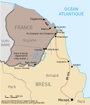
Coordinates W 051° 48' 14.70" / N 03° 53' The Oyapock River Bridge is cable-stayed bridge built and expected to be inaugurated in 2011. It will span the Oyapock River to link the cities of Oiapoque in Brazil and Saint-Georges de l'Oyapock in French Guiana.
Though there were plans to build this bridge as far back as 1997, it was only after nearly 10 years of stalling and talks that a model of the bridge between France and Brazil was finally unveiled by French president Nicolas Sarkozy and Brazilian president Luiz Inácio Lula da Silva on February 14th, 2008.
The site chosen for the positioning of the bridge will require a length of 378 meters, which will include a span of approximately 200 meters over water. Valued at R$ 62.1 million (aproximatelly US$ 50 million), work on the construction of the international bridge is slated to be completed within 16 months.
Construction of the bridge is being undertaken by a partnership between EGESA and the Consórcio Metropolitano de Transportes - CMT, both of which are headquartered in Brasilia. The Professor Carlos Augusto Bittencourt Foundation - FUNCAB (based in the city of Niterói, Rio de Janeiro) was hired to oversee the environmental engineering of the project, so that the construction of the bridge does not harm the natural environment. The bridge is part of the Guianese Shield Hub of the Initiative for the Integration of the Regional Infrastructure of South America.[1] The construction of this bridge came after the signing of an international treaty between France and Brazil in July 2005. Furthermore, the connection between Route N2 and BR-156 is yet another initiative undertaken under the scope of the Brazilian government's PAC (Growth Acceleration Plan) infrastructure project.
This bridge is the first land crossing (ferries have been used historically) along the border between France and Brazil, and indeed it is the first terrestrial crossing between French Guiana and of its neighbors in northern South America. Currently, there is a good ferry that crosses the Maroni River between French Guyana and Suriname that links Albina, in Suriname, with Saint-Laurent-du-Maroni in French Guyana. It is also possible to travel from Albina to Georgetown (Guyana) by highway; it is planned to build a bridge between Suriname and Guyana [1], replacing the current ferry. Onwards to Venezuela, one can only travel by sea, but a road link is planned [2]. In this case, it will be possible to drive from Macapá to Venezuela and Colombia with only one ferry crossing.
Though the Oyapock Bridge is slated to be inaugurated in early 2012 [3], the DNIT, the Brazilian transportation department, has not received notice about the inauguration date, and has clarified that the decision regarding the date was political and not technical. As soon as the highway is opened to traffic, it will be possible to drive on uninterrupted, paved roadways from Cayenne to Macapá, the capital of the Brazilian state of Amapá.See also
- Takutu River Bridge — a similar bridge between Brazil and Guyana.
References
- ^ IIRSA.org - Guyana Shield Hub presentation
External links
France 24 - A bridge between Europe and Latin America
Gouvernement Francais Bridge on Oct. 20, 2011
Coordinates: 3°52′24″N 51°48′58″W / 3.87333°N 51.81611°W
Categories:- Bridges
- International bridges
- Brazil–French Guiana border crossings
- Bridges in Brazil borderline
- Transport in French Guiana
- French Guiana stubs
- Brazilian building and structure stubs
- Bridge (structure) stubs

Wikimedia Foundation. 2010.