- Nurlatsky District, Republic of Tatarstan
-
This article is about a district of the modern Republic of Tatarstan. For the historical district of the Tatar ASSR, see Nurlatsky District, Tatar ASSR.
Nurlatsky District (English)
Нурлатский район (Russian)
Нурлат районы (Tatar)
Нурлат районĕ (Chuvash)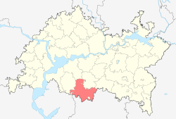
Location of Nurlatsky District on the map of the Republic of Tatarstan
Coat of arms Flag Administrative status (as of 2009) Country Russia Federal subject Republic of Tatarstan[1] Administrative center town of Nurlat[citation needed] # of rural localities 81[citation needed] - # of urban settlements 1[citation needed] - # of rural settlements 25[citation needed] Statistics Area 2,293.8 km2 (885.6 sq mi)[citation needed] Population (2010 Census,
preliminary)27,515 inhabitants[2] Population (2002 Census) 29,969 inhabitants[3] - Urban population 0% - Rural population 100% Density 12 /km2 (31 /sq mi)[4] Time zone MSD (UTC+04:00)[5] Established August 10, 1930[citation needed] District newspaper The Friendship[citation needed] Official website Nurlatsky District (Russian: Нурла́тский райо́н; Tatar Cyrillic: Нурлат районы, Latin: Nurlat rayonı) is an administrative and municipal district (raion), one of the forty-three in the Republic of Tatarstan, Russia. Its administrative center is the town of Nurlat (which administratively is not a part of the district). District's population: 27,515 (2010 Census preliminary results);[2] 29,969 (2002 Census);[6] 54,363 (1989 Census).[7]
Contents
History
The district was established on August 10, 1930 as Oktyabrsky (Russian: Октя́брьский) and was renamed Nurlatsky on December 10, 1997.[8]
Demographics
The major ethnicities living in the district are Tatars (44.2%), Chuvash (29.1%), and Russians (25.6%) (1989).
Geography and economy
The district is a flat country, 100–150 m above the sea level. Rivers flowing through the district include the Bolshoy Cheremshan, its tributary Zur Solcha, and Kondurcha.
The soils of the district are primarily leached, typical and podzolized chernozems, taupe forest soils, meadow-chernozem. More than 35% of the district is covered with forests, and timber industry is developed as a result. Deposits of oil, natural gas, peat, and bentonite are also common. Industry is mostly concentrated in Nurlat.
In 2002, agricultural holding numbered 1,211 square kilometers (468 sq mi), including 915 square kilometers (353 sq mi) of tilled lands. Wheat, winter rye, oats, millets, peas, sugar beets, potatoes are cultivated in winter and spring. Dairy-and-meat livestock, sheep, and pigs are bred.
Transport
The Ulyanovsk–Ufa railway and the Chistopol–Nurlat autoroute cross the territory of the district.
Other statistics
In 2003, there were 64 secondary schools with 10,728 students, 52 libraries, 61 clubs, and five hospitals with the total of 546 beds.
The district's newspaper is The Friendship (Tatar Cyrillic: Дуслык, Latin: Duslıq; Russian: Дружба, Druzhba; Chuvash: Туслăх, Tuslăx).
Divisions
Administrative divisions
Nurlatsky District has administrative jurisdiction over all of its eighty-one rural localities.
Municipal divisions
Municipally, the district is divided into twenty-five rural settlements:
- Akhmetovskoye (Ахметовское)
- Administrative center: village of Akhmetovo
- other localities of the rural settlement:
- settlement of zheleznodorozhnogo razyezda Akhmetovo
- selo of Aksumla
- settlement of Chishma
- village of Chuvashskaya Mencha
- village of Osinovka
- village of Yerepkino
- Amzinskoye (Амзинское)
- Administrative center: selo of Novaya Amzya
- other localities of the rural settlement:
- village of Cherebatyrevo
- settlement of Kzyl Yul
- village of Staraya Russkaya Amzya
- village of Staraya Tatarskaya Amzya
- Andreyevskoye (Андреевское)
- Administrative center: selo of Andreyevka
- other localities of the rural settlement:
- settlement of Imeni III Syezda
- Bikulovskoye (Бикуловское)
- Administrative center: village of Bikulovo
- Bilyar-Ozerskoye (Биляр-Озерское)
- Administrative center: selo of Bilyar-Ozero
- other localities of the rural settlement:
- selo of Yerykla
- Bogdashkinskoye (Богдашкинское)
- Administrative center: selo of Russkoye Bogdashkino
- Burmetyevskoye (Бурметьевское)
- Administrative center: selo of Burmetyevo
- other localities of the rural settlement:
- selo of Kurmanayevo
- village of Urnyak
- Chulpanovskoye (Чулпановское)
- Administrative center: selo of Chulpanovo
- Fomkinskoye (Фомкинское)
- Administrative center: selo of Fomkino
- Gaytankinskoye (Гайтанкинское)
- Administrative center: selo of Gaytankino
- other localities of the rural settlement:
- village of Chyornoye Ozero
- selo of Krivoye Ozero
- settlement of Stary Aul
- Kichkalninskoye (Кичкальнинское)
- Administrative center: selo of Kichkalnya
- Kulbayevo-Marasinskoye (Кульбаево-Марасинское)
- Administrative center: selo of Kulbayevo-Marasa
- other localities of the rural settlement:
- village of Kurnali-Amzya
- village of Seltso Kulbayevo Marasa
- Mamykovskoye (Мамыковское)
- Administrative center: selo of Mamykovo
- other localities of the rural settlement:
- settlement of Butaikha
- Novoiglaykinskoye (Новоиглайкинское)
- Administrative center: selo of Novoye Iglaykino
- other localities of the rural settlement:
- settlement of zheleznodorozhnogo razyezda Klinovka
- settlement of Nekrasovka
- village of Staroye Iglaykino
- village of Svetloye Ozero
- settlement of Tukay
- Novotumbinskoye (Новотумбинское)
- Administrative center: selo of Novaya Tumba
- other localities of the rural settlement:
- settlement of Pokrovsky
- Selengushskoye (Селенгушское)
- Administrative center: selo of Selengushi
- other localities of the rural settlement:
- village of Zuzeyevo
- Srednekamyshlinskoye (Среднекамышлинское)
- Administrative center: selo of Srednyaya Kamyshla
- other localities of the rural settlement:
- village of Ablyaskino
- settlement of Krasny Oktyabr
- village of Malaya Kamyshla
- settlement of Mikhaylovka
- village of Vishnyovaya Polyana
- Staroalmetyevskoye (Староальметьевское)
- Administrative center: selo of Staroye Almetyevo
- other localities of the rural settlement:
- settlement of imeni Narimanova
- village of Novoye Almetyevo
- Starochelninskoye (Старочелнинское)
- Administrative center: selo of Starye Chelny
- other localities of the rural settlement:
- selo of Nizhniye Chelny
- village of Sredniye Chelny
- Stepnoozerskoye (Степноозерское)
- Administrative center: selo of Stepnoye Ozero
- other localities of the rural settlement:
- settlement of Beryozovka
- village of Ilyutkino
- Timerlekskoye (Тимерлекское)
- Administrative center: selo of Chuvashsky Timerlek
- other localities of the rural settlement:
- settlement of Krasnomaysky
- settlement of Rozhdestvensky
- village of Russky Timerlek
- settlement of Stekolny
- Tyurnyasevskoye (Тюрнясевское)
- Administrative center: selo of Tyurnyasevo
- other localities of the rural settlement:
- settlement of Pervoy brigady sovkhoza
- settlement of Gaytanskogo otdeleniya sovkhoza
- Yakushkinskoye (Якушкинское)
- Administrative center: selo of Yakushkino
- other localities of the rural settlement:
- village of Abryskino
- village of Saldakayevo
- Yegorkinskoye (Егоркинское)
- Administrative center: selo of Yegorkino
- other localities of the rural settlement:
- village of Karaulnaya Gora
- village of Russkaya Mencha
- village of Yedineniye
- Yelaurskoye (Елаурское)
- Administrative center: selo of Yelaur
- other localities of the rural settlement:
- village of Berlek-Mikhaylovka
- selo of Kirpichnoye
- settlement of Oktyabrina
- settlement of Petrovsky
- village of Sosnovka
- Zarechenskoye (Зареченское)
- Administrative center: settlement of Zarechny
- other localities of the rural settlement:
- village of Turnoyas
- settlement of Yugan
References
- ^ Constitution, Article 65.2
- ^ a b Федеральная служба государственной статистики (Federal State Statistics Service) (2011). "Предварительные итоги Всероссийской переписи населения 2010 года (Preliminary results of the 2010 All-Russian Population Census)" (in Russian). Всероссийская перепись населения 2010 года (All-Russia Population Census of 2010). Federal State Statistics Service. http://www.perepis-2010.ru/results_of_the_census/results-inform.php. Retrieved 2011-04-25.
- ^ Федеральная служба государственной статистики (Federal State Statistics Service) (2004-05-21). "Численность населения России, субъектов Российской Федерации в составе федеральных округов, районов, городских поселений, сельских населённых пунктов – районных центров и сельских населённых пунктов с населением 3 тысячи и более человек (Population of Russia, its federal districts, federal subjects, districts, urban localities, rural localities—administrative centers, and rural localities with population of over 3,000)" (in Russian). Всероссийская перепись населения 2002 года (All-Russia Population Census of 2002). Federal State Statistics Service. http://www.perepis2002.ru/ct/doc/1_TOM_01_04.xls. Retrieved 2010-03-23.
- ^ The value of density was calculated automatically by dividing the 2010 Census population by the area specified in the infobox. Please note that this value may not be accurate as the area specified in the infobox does not necessarily correspond to the area of the entity proper or is reported for the same year as the population.
- ^ Правительство Российской Федерации. Постановление №725 от 31 августа 2011 г. «О составе территорий, образующих каждую часовую зону, и порядке исчисления времени в часовых зонах, а также о признании утратившими силу отдельных Постановлений Правительства Российской Федерации». Вступил в силу по истечении 7 дней после дня официального опубликования. Опубликован: "Российская Газета", №197, 6 сентября 2011 г. (Government of the Russian Federation. Resolution #725 of August 31, 2011 On the Composition of the Territories Included into Each Time Zone and on the Procedures of Timekeeping in the Time Zones, as Well as on Abrogation of Several Resolutions of the Government of the Russian Federation. Effective as of after 7 days following the day of the official publication).
- ^ Федеральная служба государственной статистики (Federal State Statistics Service) (2004-05-21). "Численность населения России, субъектов Российской Федерации в составе федеральных округов, районов, городских поселений, сельских населённых пунктов – районных центров и сельских населённых пунктов с населением 3 тысячи и более человек (Population of Russia, its federal districts, federal subjects, districts, urban localities, rural localities—administrative centers, and rural localities with population of over 3,000)" (in Russian). Всероссийская перепись населения 2002 года (All-Russia Population Census of 2002). Federal State Statistics Service. http://www.perepis2002.ru/ct/doc/1_TOM_01_04.xls. Retrieved 2010-03-23.
- ^ "Всесоюзная перепись населения 1989 г. Численность наличного населения союзных и автономных республик, автономных областей и округов, краёв, областей, районов, городских поселений и сёл-райцентров. (All Union Population Census of 1989. Present population of union and autonomous republics, autonomous oblasts and okrugs, krais, oblasts, districts, urban settlements, and villages serving as district administrative centers.)" (in Russian). Всесоюзная перепись населения 1989 года (All-Union Population Census of 1989). Demoscope Weekly (website of the Institute of Demographics of the State University—Higher School of Economics. 1989. http://demoscope.ru/weekly/ssp/rus89_reg.php. Retrieved 2010-03-23.
- ^ Resolution of the State Council of the Republic of Tatarstan #1415 of December 10, 1997 On Assigning the Status of a Town Under Republic's Jurisdiction to the Town of Nurlat of Oktyabrsky District and on Re-Designating Oktyabrsky District as Nurlatsky District of the Republic of Tatarstan.
Sources
- 6 ноября 1992 г. «Конституция Республики Татарстан», в ред. Закона №55-ЗРТ от 14 марта 2005 г «О внесении изменений и дополнений в Конституцию Республики Татарстан». Опубликован: "Ведомости Верховного Совета Татарстана", №9-10, ст. 166, 1992. (November 6, 1992 Constitution of the Republic of Tatarstan, as amended by the Law #55-ZRT of March 14, 2005 On Amending and Supplementing the Constitution of the Republic of Tatarstan. ).
- Law of the Republic of Tatarstan #32-ZRT of January 31, 2005 On Establishing the Borders of the Territories and the Status of the Municipal Formation of "Nurlatsky Municipal District" and the Municipal Formations Within Its Structure
- (Tatar) "Nurlat rayonı/Нурлат районы". Tatar Encyclopedia. Kazan: Tatarstan Republic Academy of Sciences Institution of the Tatar Encyclopaedia. 2002.
Administrative divisions of the Republic of Tatarstan Capital: Kazan
Cities and towns Agryz · Almetyevsk · Arsk · Aznakayevo · Bavly · Bolgar · Bugulma · Buinsk · Chistopol · Laishevo · Leninogorsk · Mamadysh · Mendeleyevsk · Menzelinsk · Naberezhnye Chelny · Nizhnekamsk · Nurlat · Tetyushi · Yelabuga · Zainsk · Zelenodolsk
Administrative districts Agryzsky · Aksubayevsky · Aktanyshsky · Alexeyevsky · Alkeyevsky · Almetyevsky · Apastovsky · Arsky · Atninsky · Aznakayevsky · Baltasinsky · Bavlinsky · Bugulminsky · Buinsky · Cheremshansky · Chistopolsky · Drozhzhanovsky · Kamsko-Ustyinsky · Kaybitsky · Kukmorsky · Laishevsky · Leninogorsky · Mamadyshsky · Mendeleyevsky · Menzelinsky · Muslyumovsky · Nizhnekamsky · Novosheshminsky · Nurlatsky · Pestrechinsky · Rybno-Slobodsky · Sabinsky · Sarmanovsky · Spassky · Tetyushsky · Tukayevsky · Tyulyachinsky · Verkhneuslonsky · Vysokogorsky · Yelabuzhsky · Yutazinsky · Zainsky · ZelenodolskyCategories:- Districts of Tatarstan
- Akhmetovskoye (Ахметовское)


Wikimedia Foundation. 2010.