- Mueang Phrae District
-
Mueang Phrae
เมืองแพร่— Amphoe — Amphoe location in Phrae Province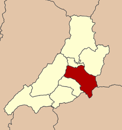
Coordinates: 18°8′44″N 100°8′29″E / 18.14556°N 100.14139°ECoordinates: 18°8′44″N 100°8′29″E / 18.14556°N 100.14139°E Country  Thailand
Province Phrae Seat Tambon Muban Amphoe established Area - Total 756.1 km2 (291.9 sq mi) Population (2005) - Total 123,811 - Density 163.7/km2 (424/sq mi) Time zone THA (UTC+7) Postal code 54000 Geocode 5401 Mueang Phrae (Thai: เมืองแพร่; IPA: [mɯ̄aŋ pʰrɛ̂ː]) is the capital district (Amphoe Mueang) of Phrae Province, northern Thailand.
Geography
Neighboring districts are (from the southwest clockwise) Sung Men, Long, Nong Muang Khai, Rong Kwang of Phrae Province, Na Muen of Nan Province and Tha Pla of Uttaradit Province.
Administration
The district is subdivided into 20 subdistricts (tambon), which are further subdivided into 157 villages (muban). Phrae itself is a town (thesaban mueang) and cover the complete tambon Nai Wiang. There are three more townships (thesaban tambon) - Thung Hong and Mae Lai both cover the complete same-named tambon, Cho Hae covers the complete tambon Cho Hae and parts of Padaeng. There are further 15 Tambon administrative organizations (TAO).
No. Name Thai name Villages Inh. 1. Nai Wiang ในเวียง - 17,971 2. Na Chak นาจักร 8 6,381 3. Nam Cham น้ำชำ 4 1,769 4. Pa Daeng ป่าแดง 10 5,147 5. Thung Hong ทุ่งโฮ้ง 7 6,397 6. Mueang Mo เหมืองหม้อ 12 9,301 7. Wang Thong วังธง 5 2,683 8. Mae Lai แม่หล่าย 6 4,662 9. Huai Ma ห้วยม้า 14 6,964 10. Pa Maet ป่าแมต 14 12,181 11. Ban Thin บ้านถิ่น 8 6,910 12. Suan Khuean สวนเขื่อน 10 5,635 13. Wang Hong วังหงส์ 7 3,531 14. Mae Kham Mi แม่คำมี 11 7,815 15. Thung Kwao ทุ่งกวาว 6 6,157 16. Tha Kham ท่าข้าม 5 2,522 17. Mae Yom แม่ยม 4 2,028 18. Cho Hae ช่อแฮ 10 7,281 19. Rong Fong ร่องฟอง 4 3,703 20. Kanchana กาญจนา 9 4,773 Mueang Phrae · Rong Kwang · Long · Sung Men · Den Chai · Song · Wang Chin · Nong Muang Khai
Categories:- Amphoe of Phrae
- Northern Thailand geography stubs

Wikimedia Foundation. 2010.