- Trenton/Mountain View Airport
-
Trenton/Mountain View Airport 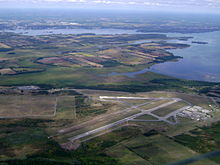
IATA: none – ICAO: none – TC LID: CPZ3 Summary Airport type Military Operator DND Location Mountain View, Ontario Elevation AMSL 362 ft / 110 m Coordinates 44°04′10″N 077°20′17″W / 44.06944°N 77.33806°WCoordinates: 44°04′10″N 077°20′17″W / 44.06944°N 77.33806°W Map Location in Ontario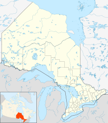
 CPZ3
CPZ3Runways Direction Length Surface ft m 06R/24L 5,000 1,524 Asphalt 06L/24R 4,800 1,463 Gravel 16/34R 3,000 914 Crushed concrete/asphalt Source: Canada Flight Supplement[1] Trenton/Mountain View Airport, (TC LID: CPZ3), is located 5.2 NM (9.6 km; 6.0 mi) southeast of Mountain View, Ontario, Canada.
The airport serves as an Royal Canadian Air Cadets flying centre from May until October and as a flight training centre from June until the end of August each summer. Stored at the airport are retired Canadian Forces aircraft, including the Canadair CL-41 Tutor and Canadair T-33 (T-33 Shooting Star), but others such as Canadair CF-5s and OH-58s also reside here but in smaller numbers.
A new gravel runway was constructed in 2006 to train Canadian Forces C130 Hercules aircraft crew in landing on unprepared landing strips. The Canadian Forces have also established a drop zone nearby.
See also
- CFD Mountain View
References
- ^ Canada Flight Supplement. Effective 0901Z 20 October 2011 to 0901Z 15 December 2011
Airports in Canada By name A–B · C–D · E–G · H–K · L–M · N–Q · R–S · T–ZBy location indicator CA · CB · CC · CD · CE · CF · CG · CH · CI · CJ · CK · CL · CM · CN · CO · CP · CR · CS · CT · CV · CW · CY · CZBy province/territory National Airports System Calgary · Charlottetown · Edmonton · Fredericton · Gander · Halifax · Iqaluit · Kelowna · London · Moncton · Montréal-Mirabel · Montréal-Trudeau · Ottawa · Prince George · Québec · Regina · Saint John · St. John's · Saskatoon · Thunder Bay · Toronto · Vancouver · Victoria · Whitehorse · Winnipeg · YellowknifeRelated List of airports by ICAO code: C · List of defunct airports in Canada · List of heliports in Canada · List of international airports in Canada · National Airports System · Operation Yellow RibbonCategories:- Airports in Ontario
- Ontario airport stubs


Wikimedia Foundation. 2010.