- Iqaluit Airport
Infobox Airport
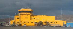
name = Iqaluit Airport
IATA = YFB
ICAO = CYFB
type = Public
owner-oper = Government of Nunavut [http://www.tc.gc.ca/programs/Airports/Status/menu.htm Airport Divestiture Status Report] ]
city-served =
location =Iqaluit
elevation-f = 110
elevation-m = 34
coordinates = coord|63|45|23|N|068|33|21|W|type:airport|display=inline
website =
r1-number = 17/35
r1-length-f = 8,600
r1-length-m = 2,621
r1-surface =Asphalt
stat-year = 2007
stat1-header = Aircraft Movements
stat1-data = 19,230
footnotes = Sources:Canada Flight Supplement CFS]
Statistics fromTransport Canada . [http://www.tc.gc.ca/pol/EN/Report/TP577/pdf/TP577_07.pdf Aircraft Movement Statistics: NAV CANADA Towers and Flight Service Stations: Annual Report 2007] ]Iqaluit Airport Airport codes|YFB|CYFB serves
Iqaluit ,Nunavut ,Canada and is located adjacent to the town. It is operated by the government of Nunavut. It hosts scheduled passenger service from Ottawa, Montreal, Rankin Inlet and Kuujjuaq on carriers such asFirst Air andCanadian North , as well as from smaller communities throughout eastern Nunavut. It is also used as aforward operating base by theCF-188 Hornet .The airport is classified as an
airport of entry byNAV CANADA and is staffed by theCanada Border Services Agency . CBSA officers at this airport currently can handlegeneral aviation aircraft only, with no more than 15 passengers.History
During
World War II , the US established a weather/radio station at the site, code-named "Crystal Two", and then built an airstrip in 1942-43 as part of theCrimson Route betweenCalifornia and theUnited Kingdom . Through this forbidding place passed hundreds of aircraft destined for the Allies viaGreenland andIceland . Frobisher Bay's fortunes faded with the end of World War II. Soon, however, theCold War stimulated construction of the Distant Early Warning (DEW) Line, to defend North America fromSoviet nuclear bomber attack. DEW Line radar sites stretched from the Alaska-Yukon border across Northern Canada and into Greenland. Frobisher Bay again became an important staging point, as the eastern DEW Line air base for building supplies flown north by the Military Air Transport Service (MATS) of theUS Air Force (USAF), supported by a huge civilian fleet. At one time YFB saw 300 aircraft movements a day. Once the DEW Line opened in 1957 the airlift subsided and a second hiatus visited YFB.Henceforth, YFB became something of a backwater, with
Strategic Air Command air refuelling operations sustained mostly by MATS cargo flights (usually operated byDouglas C-124 Globemaster IIs). When the USAF closed its base in 1963, Iqaluit was left to survive as a commercial airport. Since the Fifties, however, YFB had earned another reputation-as a technical stop for airlines plying the North Atlantic. Naturally, crews departing westward from Prestwick or Shannon in those years preferred to route via Iceland (or theAzores ) to Gander, thence to New York or elsewhere. Weather, however, could dictate a northerly course, which is when YFB came into its own. At one time, Pan American even had a base there and on at least two occasions had to change engines onDouglas DC-7 Cs at YFB.With the introduction of the intercontinental
Boeing 707 andDouglas DC-8 , fewer airlines stopped at Iqaluit. Even so, there always seemed to be some activity. The place remained prominent as a regional airport, continued in its strategic role of sustaining the DEW Line, supported the occasional military exercise or scientific expedition, and was still a key stopover on the North Atlantic ferry route. As quiet as things might become, YFB was not about to disappear.Through the Sixties,
Nordair was the main airline serving YFB fromMontreal, Canada , 1,100nm (2,040km) to the south.Douglas DC-4 s operated into the Seventies and LockheedSuper Constellation s from between 1964 and 1969. Nordair surprised everyone in 1968 by boldly introducing theBoeing 737-200 on the Frobisher Bay run. At the same time,Bradley Air Services had been expanding. By the Seventies, the company's fleet ofDeHavilland CanadaDHC-6 Twin Otter s andDouglas DC-3 s was servicing many small Arctic communities from YFB, carrying passengers, mail, groceries, and other essentials. Bradley became known as First Air in 1973 and soon added BAe 748s.In the Eighties, Canada's airline industry was in transition, with
Air Canada andCanadian Airlines rapidly buying up regional operators. Air Canada acquired Nordair in 1977, and then sold it in 1984 to Canadian Airlines. Jet service to YFB continued, but under theCanadian North banner. With all these changes, First Air sensed an opportunity. Between 1985 and 1988 it added four Boeing 727s to link Montreal and Ottawa with Iqaluit. Meanwhile Canadian Airlines failed, and was taken over by Air Canada in 2000. First Air continued to expand, but cautiously so. In 1995, it purchased the small Yellowknife-based carrierPtarmigan Airways ; then, in 1997,Northwest Territorial Airways (NWT Air), Air Canada'sYellowknife subsidiary. In the NWT Air move First Air acquired three solid money-makers: two 737-200 Combis and a Lockheed 382 Hercules. ["Airways " (June 2006) "Pages 24-28" "YFB and First Air"]Facilities
* 1 hangar/cargo terminals
* 1 two story terminal building
* 1 main runway
* three apronsThe main terminal has:
* check-in desks
* 3 gates
* 1 baggage claim belt
* Gift Shop
* Travel Agent
* Tourist Help Desk
* Car Rental
* Taxi Service/Rank
* Baby/Parent Room
* Disabled Access/FacilitiesThere are 30 short term parking spaces at the airport.
Other information
On
May 31 1996 , Virgin Atlantic flight 7 fromLondon to Los Angeles made anemergency landing at Iqaluit after a passenger had a heart attack. The landing was executed safely - the firstBoeing 747 ever to attempt to land at Iqaluit - but one of the 747's engines hit a fuel pump on the tarmac as it was taxiing, causing serious damage to the aircraft and a potentially dangerous fuel spill. The 397 stranded passengers, including singerGary Barlow , were flown out after Virgin Atlantic chartered two jets. The passengers, after spending 16 hours in a localcurling rink, were taken toNew York City to catch connecting flights to Los Angeles.Prince Michael of Kent , who had also been on the flight, was given aRoyal Canadian Mounted Police escort and departed on an earlier scheduled flight. The original aircraft had its engines repaired and left four days after the accident. [ [http://www.nunatsiaq.com/archives/back-issues/week/60607.html#7 Unexpected Arctic stop for Brits, Yanks] ]On
14 August 1996 aCanadian Forces CF-18 Hornet left the runway duringtakeoff , slid down an embankment and ruptured a fuel pipeline. The aircraft caught fire, as did fuel spilling from the pipeline, however the pilot had ejected just as the plane left the runway and suffered a broken ankle. The pipeline was shut down and the fire brought under control in less than an hour. [ [http://www.nunatsiaq.com/archives/back-issues/week/60816.html#1 Pilot ejects in nick of time as CF-18 crashes while attempting to take off.] ]There is a persistent but false rumour that Iqaluit Airport is one of the emergency landing sites for
NASA 'sSpace Shuttle , due to the length of its runway and its geographic location. [ [http://www.globalsecurity.org/space/facility/sts-els.htm List of Space Shuttle emergency landing sites at GlobalSecurity.org] ] This can easily be disproved by noting that Iqaluit's runway is less than convert|9000|ft|m long.The
Airbus A380 , the world's largest passenger jet, conducted cold weather testing from Iqaluit Airport during February 2006 - its first North American visit. They were hoping to experience -25 °C (-13 °F) weather to determine the effects on cabin temperatures and engine performance. Nunavut authorities hope that the importance of this test will put Iqaluit on the map as a centre for cold-weather testing. [ [http://www.cbc.ca/story/canada/national/2006/02/06/jumbojet060206.html CBC report] ]In December 2005 the Government of Nunavut announced that they would spend $40 million to repair the runway, build a new emergency services facility and a new terminal. [ [http://www.nunatsiaq.com/archives/51216/news/nunavut/51216_11.html Nunatsiaq News] ]
At 3AM on Friday, August 15, 2008, American Airlines flight 283 from
Delhi toChicago was diverted to Iqaluit Airport due to an onboard medical emergency, with a passenger suffering from acutekidney stone s. The passenger was transported to the local medical center, and the plane refueled and then left 2.5 hours later, continuing its journey to Chicago. The flight crew likened taxiing on the populous ramp to driving a Buick on a bumper pool table.Airlines and destinations
*
Canadian North (Cambridge Bay, Cape Dorset, Clyde River, Hall Beach, Igloolik, Ottawa, Pangnirtung, Pond Inlet, Qikiqtarjuaq, Rankin Inlet, Yellowknife) [ [http://www.canadiannorth.com/pdfs/flight_schedule_JULY22-2008.pdf Canadian North flight schedule] ]
*First Air (Cape Dorset, Clyde River, Hall Beach, Igloolik, Kimmirut, Kuujjuaq, Montreal, Nanisivik, Ottawa, Pangnirtung, Pond Inlet, Qikiqtarjuaq, Rankin Inlet, Resolute) [ [http://www.firstair.ca/weather/index.html First Air interactive weather/route map] ]
*Kenn Borek Air
*Air Nunavut
*Canadian Helicopters
*Unaalik Aviation References
External links
Wikimedia Foundation. 2010.