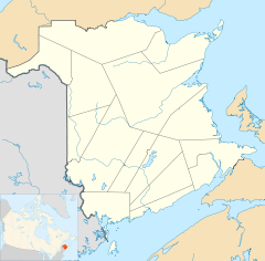
- Mount Whatley, New Brunswick
-
Mt. Whatley in New Brunswick
Mt. Whatley is a community in the Canadian province of New Brunswick, located in Westmorland County on New Brunswick Highway 16. Mt. Whatley is situated upon the Aulac Ridge, a prominent rise running west-east across the Tantramar Marshes on the Isthmus of Chignecto,on the shore of the Missaguash River which forms the southern part of the inter-provincial boundary with Nova Scotia.The community is linked by a small bridge to Fort Lawrence Nova Scotia .
References
Coordinates: 45°52′53.9″N 64°15′39.9″W / 45.881639°N 64.261083°W
Subdivisions of New Brunswick 
Subdivisions Cities Villages Alma · Aroostook · Atholville · Baker Brook · Balmoral · Bas-Caraquet · Bath · Belledune · Bertrand · Blacks Harbour · Blackville · Cambridge-Narrows · Canterbury · Cap-Pelé · Centreville · Charlo · Chipman · Clair · Doaktown · Dorchester · Drummond · Eel River Crossing · Fredericton Junction · Gagetown · Grand Manan · Grande-Anse · Grande-Digue · Harvey Station · Hillsborough · Kedgwick · Maisonnette · McAdam · Meductic · Memramcook · Millville · Minto · Neguac · New Maryland · Norton · Paquetville · Perth-Andover · Petit-Rocher · Petitcodiac · Plaster Rock · Pointe-Verte · Port Elgin · Rexton · Riverside-Albert · Rivière-Verte · Rogersville · Saint-Antoine · Sainte-Anne-de-Madawaska · Saint-François-de-Madawaska · Saint-Hilaire · Saint-Isidore · Saint-Léolin · Saint-Louis-de-Kent · Sainte-Marie-Saint-Raphaël · St. Martin's · Salisbury · Stanley · Sussex Corner · Tracy · Tide HeadCategories:- Communities in Westmorland County, New Brunswick
- New Brunswick geography stubs
Wikimedia Foundation. 2010.

