Mount Warrenheip

Mount Warrenheip
Mount Warrenheip

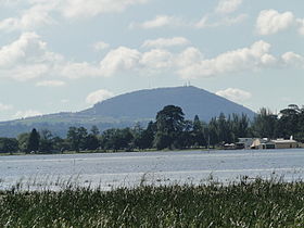
Mount Warrenheip in the distance behind Lake Wendouree
Elevation 714 m (2,343 ft) AHD
Listing List of volcanoes in Australia
Location
Victoria
Mount Warrenheip
Warrenheip, Australia
Coordinates 37°39′S 143°56′E / 37.65°S 143.933°E / -37.65; 143.933Coordinates: 37°39′S 143°56′E / 37.65°S 143.933°E / -37.65; 143.933

Mount Warrenheip is an inactive Volcanic cone in Victoria, Australia rising 714 metres above sea level. The mountain is a landmark of Dunnstown, Victoria the closest large town as well as the city of Ballarat with the mountain being located at its outskirts in the suburb of Warrenheip, Victoria. Mount Warrenheip ceased as an active volcano around 100,000 years ago.

The name Warrenheip originates from the Wathaurong word for "emu's feathers" describing the fern like vegetation which covered it.

Along with Mount Buninyong, it is one of only two forested volcanic cones in Victoria.

Mount Warrenheip has telecommunications antennae at its peak and its foothills are the location of Kryal Castle and cattle grazing.


Wikimedia Foundation. 2010.

Игры ⚽ Поможем решить контрольную работу

Look at other dictionaries:

  • Mount Clear, Victoria — Mount Clear Ballarat, Victoria …   Wikipedia

  • Mount Pleasant, Victoria — Mount Pleasant Ballarat, Victoria Barkly Street near the intersection of Cobden Street looking south …   Wikipedia

  • Mount Egerton, Victoria — Mount Egerton Victoria Mount Egerton General Store …   Wikipedia

  • Volcanes de la Tierra — Anexo:Volcanes de la Tierra Saltar a navegación, búsqueda Contenido 1 Afganistán 2 Alemania 3 Antártica 4 …   Wikipedia Español

  • Geelong-Ballarat railway line, Victoria — VictorianRailwayLineInfobox type = vic name = Geelong Ballarat yearcommenced = 1858 yearopened = 1862 yearcompleted = yearclosed = fate = lengthkm = stations = tracks = Single track, crossing loops users = Freight servicepattern = RollingStock =… …   Wikipedia

  • List of localities in Victoria (Australia) — Map of Local Government Areas in Victoria This is a list of locality names and populated place names in the state of Victoria, Australia, outside the Melbourne metropolitan area. It is organised by region from the south west of the state to the… …   Wikipedia

  • Shire of Moorabool — Victoria Location in Victoria Population …   Wikipedia

  • City of Ballarat — Victoria Map of the City of Ballarat s municipal borders, urban areas and location in Victoria …   Wikipedia

  • Electoral districts of Victoria — The Victorian Legislative Assembly is elected from 88 single member electorates called districts.Current districtsThis is a list of districts as of 2005.* Electoral district of Albert Park * Electoral district of Altona * Electoral district of… …   Wikipedia

  • Myrniong, Victoria — Myrniong Victoria Myrniong seen from the west. The Western Freeway can be seen to the right …   Wikipedia

Share the article and excerpts

Direct link
Do a right-click on the link above
and select “Copy Link”