- Moore, Queensland
-
Moore
Queensland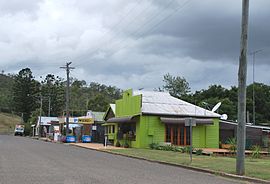
Shops in Moore
 Moore
MoorePopulation: 169[1] Postcode: 4306 Location: LGA: Somerset Region County: Cavendish Parish: Colinton State District: Nanango Federal Division: Blair Moore is a town in South East Queensland, 96 kilometres (60 mi) north west of Brisbane. It is situated at the base of the Balfour Range on the D'Aguilar Highway, between Esk in the Brisbane River valley and Yarraman in the South Burnett.
At the 2006 census, Moore and the surrounding area had a population of 169.[1]
References
- ^ a b Australian Bureau of Statistics (25 October 2007). "Moore (Esk Shire) (State Suburb)". 2006 Census QuickStats. http://www.censusdata.abs.gov.au/ABSNavigation/prenav/LocationSearch?collection=Census&period=2006&areacode=SSC36785&producttype=QuickStats&breadcrumb=PL&action=401. Retrieved 2008-12-11.
Towns and suburbs in the Somerset Region | West Moreton | South East Queensland Banks Creek · Borallon · Caboonbah · Clarendon · Colinton · Coolana · Coominya · Dundas · England Creek · Esk · Fairney View · Fernvale · Glamorgan Vale · Glenfern · Harlin · Hazeldean · Jimna · Kilcoy · Lake Somerset · Lake Wivenhoe · Lark Hill · Linville · Lowood · Minden · Monsildale · Moore · Mount Hallen · Mount Tarampa · Prenzlau · Rifle Range · Tarampa · Toogoolawah · Vernor · Villeneuve · Wanora · Winya · Wivenhoe Pocket · Yabba · Yendina
Main Article: Local Government Areas of QueenslandCoordinates: 26°54′S 152°18′E / 26.9°S 152.3°E
Categories:- Towns in Queensland
- Queensland geography stubs


Wikimedia Foundation. 2010.