- Milton Mills, New Hampshire
-
Coordinates: 43°30′00″N 70°57′38″W / 43.5°N 70.96056°W Milton Mills is a census-designated place in the town of Milton in Strafford County, New Hampshire. It had a population of 299 at the 2010 census.[1]
The village is located in the northern part of the town of Milton, adjacent to the Salmon Falls River, which forms the border between New Hampshire and Maine. Applebee Road leads southwest to New Hampshire Route 125 and the center of Milton, Willey Road leads northwest to the town of Wakefield, Milton Mills Road leads east to Maine Route 109 in the town of Acton, Maine, and Foxes Ridge Road leads southeast to Lebanon, Maine, and U.S. Route 202.
Milton Mills has a separate ZIP code (03852) from the rest of the town of Milton.
References
- ^ United States Census Bureau, American FactFinder, 2010 Census figures. Retrieved March 23, 2011.
Municipalities and communities of Strafford County, New Hampshire County seat: Dover Cities 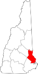
Towns Barrington | Durham | Farmington | Lee | Madbury | Middleton | Milton | New Durham | Rollinsford | Strafford
Villages Bow Lake Village | Center Strafford | East Rochester | Milton Mills
Categories:- New Hampshire geography stubs
- Census-designated places in New Hampshire
- Populated places in Strafford County, New Hampshire
- Unincorporated communities in New Hampshire

Wikimedia Foundation. 2010.