- Midgeholme
-
Coordinates: 54°55′26″N 2°33′55″W / 54.924°N 2.5654°W
Midgeholme 
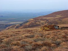
Moorland at Midgeholme
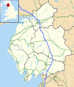
 Midgeholme shown within Cumbria
Population 67 (2001) OS grid reference SD2980 Parish Midgeholme District City of Carlisle Shire county Cumbria Region North West Country England Sovereign state United Kingdom Police Cumbria Fire Cumbria Ambulance North West EU Parliament North West England UK Parliament Penrith and The Border List of places: UK • England • Cumbria Midgeholme is a place and civil parish in the City of Carlisle district,[1] in the county of Cumbria, England. It was formerly in Border Rural District[2] It is located about 8 miles (13 km) East of Brampton.[3] Midgeholme has 1 listed building[4] called Tarn House, which is Grade II* listed.[5] The population of the civil parish of Midgeholme was 54 in 1971[6] and 67 in 2001.[7] There was once a school in Midgeholme.[8] It is also the location of Midgeholme Coalfield.[9] There is also Midgeholme Bridge in Midgeholme,[10] which carries the A689 over Hartley Burn.[11]
References
- ^ Check Browser Settings
- ^ http://www.visionofbritain.org.uk/relationships.jsp?u_id=10109681
- ^ History of Midgeholme, in Carlisle and Cumberland | Map and description
- ^ http://www.britishlistedbuildings.co.uk/england/cumbria/midgeholme
- ^ Tarn House - Midgeholme - Cumbria - England | British Listed Buildings
- ^ Old Cumbria Gazetteer, Midgeholme parish
- ^ Check Browser Settings
- ^ Old Cumbria Gazetteer, school, Midgeholme
- ^ http://www.dmm.org.uk/colliery/m039.htm
- ^ Old Cumbria Gazetteer, Midgeholme Bridge, Low Midgeholme
- ^ Midgeholme Bridge:: OS grid NY6358 :: Geograph Britain and Ireland - photograph every grid square!
External links
Categories:- Carlisle, Cumbria
- City of Carlisle
- Villages in Cumbria
- Civil parishes in Cumbria
- Cumbria geography stubs
Wikimedia Foundation. 2010.

