- Mid-February 2009 tornado outbreak
-
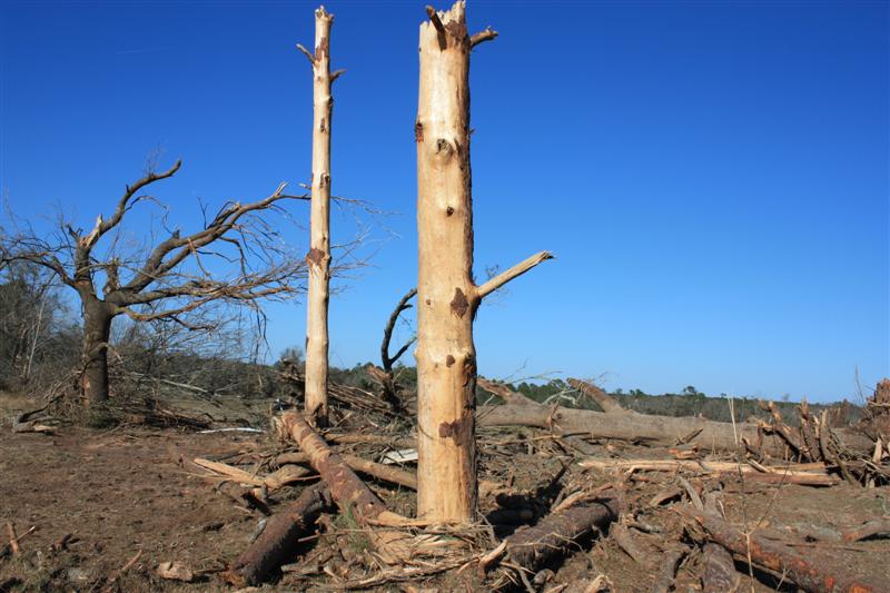
Mid-February 2009 tornado outbreak Large pine trees stripped of their bark and snapped in half near Boston, Georgia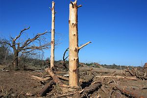
Date of tornado outbreak: February 18–February 19 Duration1: 7 hours and 38 minutes Maximum rated tornado2: EF3 tornado Tornadoes caused: 13 confirmed Damages: >$35 million (2009 USD) Fatalities: 1 (4 injuries) Areas affected: Georgia and Alabama 1Time from first tornado to last tornado
2Most severe tornado damage; see Enhanced Fujita ScaleThe Mid-February 2009 tornado outbreak was a short but damaging tornado outbreak which spawned three EF3 tornadoes from February 18 to 19. Damages from the tornadoes in Georgia was estimated to be at least $35 million, mainly from the EF2 which tracked through Grady and Thomas counties late on the 18th.[1]
Contents
Synopsis
Strong southwesterly winds transported a moist air mass northeastward across the Gulf Coast states and the Tennessee Valley. The moisture combined with daytime heating to support a moderately unstable air mass in advance of a cold front, which pushed southeastward across the Tennessee Valley and Gulf States during the afternoon and evening. The cold front combined with a strong jet stream aloft resulted in the development of severe thunderstorms along the cold front.[2] As a result, a moderate risk of severe weather was issued by the Storm Prediction Center for portions of Louisiana, Mississippi, Alabama, Georgia and the Florida Panhandle.[3]
Several tornadoes touched down during the afternoon and evening hours into the early morning of February 19. The strongest tornado was rated as an EF3 tornado, which traveled 18.6 miles (29.9 km) through Wilkes and McDuffie counties in Georgia. It destroyed a cinder block home, damaged 15 homes and destroyed 19 outbuildings. One person was killed in Hancock County after an EF3 tornado destroyed a church and four mobile homes in the area. A mile-wide EF2 tornado that touched down in Meriwether County damaged several homes with one home completely losing its roof. One person was injured by debris as an EF1 tornado traveled through Putnam County, destroying a restaurant on the southwest side of Eatonton. U.S. Highway 129 was shut down after high winds downed power lines. Two different tornadoes caused damage in Jasper County, each with winds of 100 miles per hour (160 km/h). In Newton County, 20 to 30 homes in a heavily-wooded subdivision were damaged by trees blown down by an EF1 tornado that was on the ground for 2 miles (3.2 km). Other tornadoes, with winds ranging from 70 miles per hour (110 km/h) to 90 miles per hour (140 km/h), occurred in Taylor, Houston and Oconee counties.[4] In the southern portion of Georgia, a supercell thunderstorm produced two tornadoes (rated EF2 and EF3) in Grady and Thomas counties. In Thomas County alone, there were 160 structures damaged with nine mobile homes destroyed and 20 single family homes destroyed.[5] In Alabama, an EF1 tornado tracked across a forest in Randolph County, where several hundred trees were either snapped off or blown down.[6]
Confirmed tornadoes
Confirmed
TotalConfirmed
EF0Confirmed
EF1Confirmed
EF2Confirmed
EF3Confirmed
EF4Confirmed
EF513 2 6 2 3 0 0 List of reported tornadoes - Wednesday, February 18, 2009 EF# Location County Coord. Time (UTC) Path length Damage Georgia EF0 Reynolds area Taylor 32°29′N 84°09′W / 32.483°N 84.15°W 2245 4 miles (6.4 km) An EF0 tornado, with maximum winds estimated at 70 mph (110 km/h) damaged one home, shifted a mobile home off its foundation and downed ten trees. Damages from the tornado amounted to $50,000.[7] EF0 Warner Robins Houston 32°37′N 84°38′W / 32.62°N 84.63°W 2325 17 yards (16 m) Brief tornado touched down on the runways at Robins Air Force Base with no damage reported. EF1 SW of Watkinsville Oconee 33°47′N 83°27′W / 33.78°N 83.45°W 2357 5 miles (8.0 km) Minor damage to several homes and one mobile home was shifted off its foundation. Hundreds of trees were knocked down at the Georgia Nature Center. EF3 S of Washington Wilkes, McDuffie 33°40′N 82°52′W / 33.67°N 82.86°W 0010 18.6 miles (29.9 km) One cinder block house was flattened with debris carried over 1/2 mile (800 m) away. 15 other houses and a church suffered moderate to severe damage and 19 outbuildings were destroyed. Originally rated EF4 but later downgraded. EF1 SW of Eatonton Putnam 33°18′N 83°30′W / 33.30°N 83.50°W 0015 7.5 miles (12.1 km) Significant damage along the path. A restaurant and two other buildings were destroyed and several houses sustained major damage. Several people were briefly trapped in cars and houses. One person was injured. EF1 E of Monticello Jasper 33°19′N 83°37′W / 33.31°N 83.61°W 0020 3 miles (4.8 km) Several houses were damaged, one of them severely. Many trees and power lines were also damaged. EF1 NW of Shady Dale Jasper 33°27′N 83°44′W / 33.45°N 83.73°W 0100 6.6 miles (10.6 km) A cottage was heavily damaged and five houses sustained lesser damage. Over 100 trees were knocked over. EF1 S of Porterdale Newton 33°31′N 83°53′W / 33.51°N 83.89°W 0100 3.1 miles (5.0 km) Many trees were knocked down, which damaged about 30 houses. EF2 Moreland area Meriwether, Coweta, Spalding 33°17′N 84°46′W / 33.29°N 84.77°W 0130 20 miles (32 km) Large wedge tornado caused structural damage to about 50 houses along its path, four of which were destroyed. A roof was also blown off a school. Flying debris also killed a horse. EF3 E of Sparta Hancock, Warren, Glascock 33°16′N 82°53′W / 33.26°N 82.88°W 0348 10.6 miles (17.1 km) 1 death - A church, two site-built homes and four mobile homes were destroyed along its path in the Hickory Grove community. The fatality took place in a mobile home. Hundreds of trees were also knocked down. Three others were injured. Alabama EF1 N of Rock Mills Randolph 33°14′N 85°16′W / 33.23°N 85.27°W 0050 1 mile (1.6 km) Several hundred softwood trees were damaged. No structures impacted. List of reported tornadoes - Thursday, February 19, 2009 Georgia EF2 SSE of Cairo Grady, Thomas 30°50′N 84°11′W / 30.83°N 84.18°W 0555 16.5 miles (26.6 km) Long track tornado with nine mobile homes destroyed and 160 houses damaged, of which 20 were destroyed. Many trees were also uprooted. EF3 NNW of Boston Thomas 30°50′N 83°48′W / 30.83°N 83.80°W 0623 1.5 miles (2.4 km) One barn was completely destroyed and several trees were stripped of their bark. Sources: See also
- Tornadoes of 2009
- February 2009 tornado outbreak
References
- ^ Marcus K. Garner (February 24, 2009). "Tornadoes’ toll rises to $35 million". The Atlanta Journal-Constitution. http://www.ajc.com/services/content/printedition/2009/02/24/storm0224.html. Retrieved March 27, 2009.
- ^ "Significant Severe Thunderstorms Expected Over Parts of the Gulf Coast States this Afternoon and Tonight". Storm Prediction Center. 2009-02-18. http://www.spc.noaa.gov/products/outlook/archive/2009/pwo_200902181631.html. Retrieved 2009-02-20.
- ^ "Feb 18, 2009 1300 UTC Day 1 Convective Outlook". Storm Prediction Center. 2009-02-18. http://www.spc.noaa.gov/products/outlook/archive/2009/day1otlk_20090218_1300.html. Retrieved 2009-02-20.
- ^ "Tornado Reports for North and Central Georgia for the Evening of Feb 18 2008". National Weather Service in Peachtree City, Georgia. 2009-02-20. http://www.srh.noaa.gov/ffc/html/PNSFeb1809.txt. Retrieved 2009-02-20.[dead link]
- ^ "Severe Weather of February 18–19, 2009". National Weather Service in Tallahassee, Florida. 2009-03-01. http://www.srh.noaa.gov/tae/events/20090219.php. Retrieved 2009-03-01.[dead link]
- ^ "Wehadkee Tornado - Randolph County - February 18, 2009". National Weather Service in Birmingham, Alabama. 2009-02-20. http://www.srh.noaa.gov/bmx/significant_events/2009/02_18/Randolph/index.php. Retrieved 2009-02-21.[dead link]
- ^ Stuart Hinson (2009). "Georgia Event Report: EF0 Tornado". National Climatic Data Center. http://www4.ncdc.noaa.gov/cgi-win/wwcgi.dll?wwevent~ShowEvent~749566. Retrieved June 11, 2009.
Tornado Outbreaks of 2009 February 10–11 · February 18–19 · March 8 · March 25–29 · April 9–10 · May derechos · May 13 · August 19–20 · October 29-30 · December 23-24Categories:- Tornadoes of 2009
- 2009 natural disasters in the United States
- F3 tornadoes
- Tornadoes in Alabama
- Tornadoes in Georgia (U.S. state)
Wikimedia Foundation. 2010.