- Merivale Bridge
-
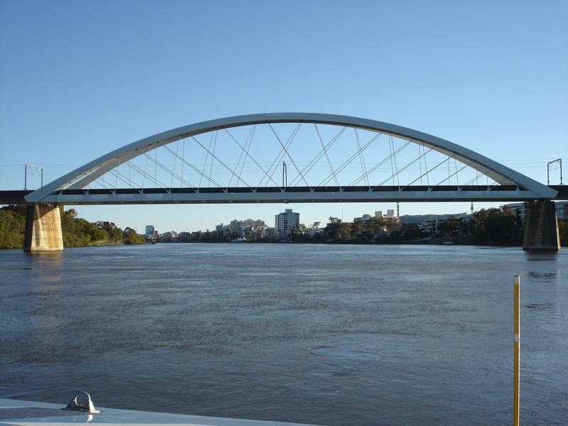
Merivale Bridge 
Official name Merivale Bridge Carries Railway Crosses Brisbane River Locale Brisbane, Queensland, Australia Design Through arch Total length 750 metres Longest span 200 metres Coordinates 27°28′10″S 153°00′47″E / 27.469383°S 153.013056°ECoordinates: 27°28′10″S 153°00′47″E / 27.469383°S 153.013056°E The Merivale Bridge is a double track railway bridge crossing the Brisbane River. It crosses the Milton Reach of the river, slightly to the west of the William Jolly Bridge. Exclusively a railway crossing, it is located between the stations of South Brisbane and Roma Street, linking the northern and southern elements of the Citytrain system. The Merivale Bridge is the only inner-city rail crossing in Brisbane. By 2016 it is expected to be over capacity, leading the Queensland Government to plan for the Cross River Rail project.[1]
The Merivale Bridge opened on 18 November 1978 by Queensland Premier Joh Bjelke-Petersen.[2] At the opening, the then Premier, described the occasion as "the start of the second stage in the history of Queensland Railways".[3]
It formed a more direct route into the city for Brisbane's southern system suburban trains than the existing route via Corinda. It also carries the standard gauge passenger trains from New South Wales. It was designed by Cameron McNamara Pty Ltd (consulting engineers) and was fabricated and erected by Transfield (Qld) Pty Ltd.
The bridge has been recognised with a number of awards. In 1980 it was named the most outstanding engineering project from the Association of Consulting Engineers of Australia.[2] Judges appreciated the combination of aesthetics and functionality. It also won the 1979 Steel Award.[2]
Contents
Almost a century coming
It had taken almost a century to get Brisbane's north and south rail networks joined by a bridge over the Brisbane River. As far back as 1885, the then Engineer-in-Chief for the Southern Division Railways arranged for the trial rail survey being done in South Brisbane to be extended across the river to the main western line near Countess Street.
In 1889, he arranged to have levels taken for alternative routes to Roma Street tunnel via Herschel Street, and to Central Station via a direct route between Turbot and Ann Streets. The Herschel Street route was recommended for adoption, and plans subsequently prepared. However the Government decided not to proceed and requested an alternative survey, but that too was held over.[3]
Pressure from south-side merchants
Worried at losing trade to central city businesses, the merchants of South Brisbane fought against the bridge. In 1913, the then Premier requested that plans for a direct route through Ann Street to Albert Square be put in hand. In 1919, the matter was raised again, but after further pressure from antilobbyists, was once more allowed to lapse.
In 1950, the issue was raised in connection with proposals to electrify the Brisbane suburban network. Surveys and plans were finalised in 1954, and in 1955 the State Government announced its decision to proceed with the construction and initiated land resumptions. However, financial constraints again caused a deferment.[3]
South East Queensland and Brisbane Region Public Transport study
This study was submitted to the Government in 1970. It recommended that the crossing should follow the route, as surveyed in 1890. The Queensland State Cabinet approved the bridge in October 1971.[2] In 1975, a contract was let to Transfield (Qld) Pty Ltd for the construction of the bridge and the line into South Brisbane station. The first pile was driven on 21 August 1975.[3]
References
- ^ Tony Moore (13 July 2010). "Brisbane CBD's new underground station revealed". Brisbane Times (Fairfax Media). http://www.brisbanetimes.com.au/queensland/brisbane-cbds-new-underground-station-revealed-20100713-108l8.html?autostart=1. Retrieved 13 July 2010.
- ^ a b c d Hogan, Janet (1982). Living History of Brisbane. Spring Hill, Queensland: Boolarang Publications. pp. 125. ISBN 0908175418.
- ^ a b c d Network Published by the Railways of Australia Committee February, 1979 pp7-11
External links
- "First Class Berth For City Rail In Infrastructure Plan". Ministerial Media Statements. http://statements.cabinet.qld.gov.au/cgi-bin/display-statement.pl?id=6230&db=media. Retrieved 10 May 2005.
- "The Merivale Rail Bridge - Brisbane". Technology in Australia. http://www.austehc.unimelb.edu.au/tia/325.html. Retrieved 10 May 2005.
- Merivale Bridge at Structurae
Bridges over the Brisbane River Sir Leo Hielscher · Story · Captain Cook · Goodwill · Victoria · Kurilpa · William Jolly · Merivale · Go Between · Eleanor Schonell · Jack Pesch · Albert · Indooroopilly Railway · Walter Taylor · Centenary
Categories:- Bridges in Brisbane
- Bridges completed in 1978
- Bridges over the Brisbane River
- Through arch bridges
- Railway bridges in Australia
- Steel bridges
Wikimedia Foundation. 2010.