- McMurray Formation
-
McMurray Formation
Stratigraphic range: late Barremian to Aptian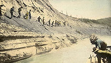
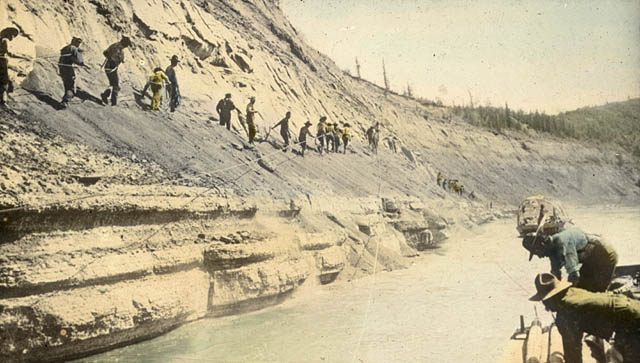
Outcrop along the Athabasca River, c. 1900Type Geological formation Unit of Mannville Group Sub-units Upper, Middle and Lower Member Underlies Clearwater Formation (Wabiskaw Member) Overlies Banff Formation, Wabamun Formation Area 140,000 km2 (54,000 sq mi)[1] Thickness up to 60 metres (200 ft)[2] Lithology Primary Sandstone Other Siltstone Location Named for Fort McMurray Named by F.H. McLearn,1917 Coordinates 56°46′24″N 111°24′13″W / 56.77328°N 111.40374°W Region north-eastrn  Alberta
Country  Canada
The McMurray Formation is a stratigraphical unit of Cretaceous age in the Western Canadian Sedimentary Basin.
It takes the name from Fort McMurray, and was first described in the outcrop occurring on the banks of the Athabasca River (5 kilometres (3.1 mi) north of Fort McMurray) by F.H. McLearn in 1917.[3]
Contents
Lithology
The McMurray Formation consists of fine grained quartzitic bitumenous sand and sandstone.
Three members were described inside the McMurray Formation, and can be differentiated in outcrops (to a lesser degree in the sub-surface):
- Lower Member: conglomeratic sandstone, present only in depressions formed in the underlying Devonian limestone.
- Middle Member: massive well sorted, fine grained oil saturated sand in the base, with inclined beds of thick rippled sandstone and thin shaley siltstone partings in the top.
- Upper Member: horizontal, argillaceous very fine grained sandstone with oil saturation
Oil/gas production
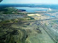
Bitumen is produced from the McMurray Formation in the Athabasca Oil Sands by open pit mining and from the sub-surface with SAGD techniques. East of Fort McMurray, it contains water instead of bitumen.
Distribution
The McMurray Formation reaches a maximum thickness of 60 metres (200 ft) in the Athabasca Oil Sands. It thins out towards the west and south. It is completely eroded north of the outcrop area.
Relationship to other units
The McMurray Formation is conformably overlain by the Wabiskaw Member of the Clearwater Formation and rests unconformably on Paleozoic limestone beds of the Banff Formation, Wabamun Formation or Winterburn Formation. The McMurray Formation is equivalent with the Ostracod Beds of the Mannville Group in central Alberta, with the Dina Member in the Lloydminster area and the Gething Formation of western and northern Alberta and northeastern British Columbia. In some interpretations it is considered part of the Mannville Group.
References
- ^ Alberta Geological Survey. "Alberta Oil Sands". http://www.ags.gov.ab.ca/energy/oilsands/alberta_oil_sands.html. Retrieved 2009-03-02.
- ^ Lexicon of Canadian Geological Units. "McMurray Formation". http://cgkn1.cgkn.net/weblex/weblex_litho_detail_e.pl?00053:009513. Retrieved 2009-02-28.
- ^ McLearn, F.H., 1917. Athabasca River section, Alberta. Geological Survey of Canada Summary Report 1916, p. 145-151.
Western Canadian Sedimentary Basin Hydrocarbon history Depositional Regions Southern Alberta · Central Alberta · Northwestern Alberta Plains · South-central Canadian Rockies foothills · North-east Plains · North-central foothills · Liard River · Fort Nelson · Northern Rocky Mountains · Fort St. John · Saskatchewan · Western ManitobaNortheastern Plains Bearpaw FM · Belly River GRP · Lea Park FM · La Biche GRP · Viking FM · Joli Fou FM · Colony SS · Mannville GRP (McLaren MBR · Grand Rapids FM · Waseca SS · Sparky SS · Gen. Petr. SS · Clearwater FM · Rex SS · Lloydminster SS · Wabiskaw MBR · Cummings MBR · McMurray FM · Dina MBR) · Banff FM · Exshaw FM · Wabamun FM · Winterburn FM · Woodbend GRP (Grosmont FM · Irteton FM · Cooking Lake FM) · Beaverhill Lake GRP · Elk Point GRP · Canadian ShieldCategories:- Stratigraphy of Alberta

Wikimedia Foundation. 2010.