- Mayabeque Province
-
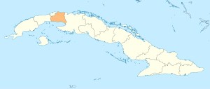
Mayabeque Province Province Country  Cuba
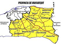
CubaMunicipalities Bejucal, San José de las Lajas, Jaruco, Santa Cruz del Norte, Madruga, Nueva Paz, Güines, Melena del Sur, Quivicán, Batabanó, San Nicolás de Bari Capital San José de las Lajas Area 3,732.73 km2 (1,441.22 sq mi) Population 381,446 (2010) Density 102.2 / km2 (264.7 / sq mi) Timezone EST (UTC-5) Area code +53-47 Mayabeque Province is one of two new provinces in Cuba, which creation was approved by the Cuban National Assembly (August 1, 2010) by splitting former La Habana province. [1] [2] Mayabeque comprises the 11 eastern municipalities of La Habana province with the capital in San José de las Lajas. Mayabeque province takes its name from the Mayabeque river (the largest in this territory) as well as, from the Mayabeque beach, in the south shore, the place in which is believed the original Havana village (San Cristóbal de La Habana) was founded in 1514. [3]
Thus, the new province becomes the smallest (excluding Havana city province) and least populated in the country. The new provinces were enforced in January 1, 2011.
Mayabeque's economy is based on Agriculture (potatoes, fruits, vegetables, sugar cane) and livestock farming, particularly milk production. It has also a relevant industry sector, mainly in San José de las Lajas and Santa Cruz del Norte (building materials, electrical cables, rubber industry, glass vessels and ceramics, food processing, paper processing, sugar mills, two large rum factories (Havana Club brand), biopharmaceuticals (in Bejucal), fishing products, power plants and oil and gas extraction). It has also important scientific institutions and university in the field of agricultural science.
Municipalities of Mayabeque Province
Municipality km² Population hab./km² Bejucal 116.36 26,966 231.7 San José de las Lajas 592.67 74,186 125.2 Jaruco 275.9 25,135 91.1 Santa Cruz del Norte 379.38 34,216 90.2 Madruga 459.58 29,805 64.9 Nueva Paz 522.8 25,471 48.7 San Nicolás 228.86 20,695 90.4 Güines 433.09 67,919 156.8 Melena del Sur 233.56 20,646 88.4 Batabanó 263.43 26,944 102.3 Quivicán 227.1 29,463 129.7 Total 3,732.73 381,446 102.2 Source: Oficina Nacional de Estadísticas e Instituto de Planificación Física/2010 [4]
The most populated cities are Güines (42 000 hab.) and San José de las Lajas (37 000 hab.)
References

City of Havana City of Havana Straits of Florida 
Artemisa Province 
Matanzas Province  Mayabeque Province

Isle of Youth Gulf of Batabanó
Canarreos ArchipelagoEnsenada de la Broa  Provinces of Cuba
Current Artemisa · Camagüey · Ciego de Ávila · Cienfuegos · Ciudad de La Habana · Granma · Guantánamo · Holguín · Isla de la Juventud · Las Tunas · Matanzas · Mayabeque · Pinar del Río · Sancti Spíritus · Santiago de Cuba · Villa Clara
Historical Batabanó · Bejucal · Güines · Madruga · Melena del Sur · Nueva Paz · San José de las Lajas · Jaruco · San Nicolás de Bari · Quivicán · Santa Cruz del Norte
Wikimedia Foundation. 2010.


