- MRT (Bangkok)
-
Mass Rapid Transit (MRT) 

Info Owner Mass Rapid Transit Authority of Thailand Locale Bangkok, Thailand Transit type Rapid transit Number of lines 1 Number of stations 18 Daily ridership Over 200,000 Operation Began operation 3 July 2004 Operator(s) Bangkok Metro PCL Number of vehicles 19 three-car Siemens Modular Metro Technical System length 20 km (12.43 mi) System map Legend
Blue Line:  Hua Lamphong – Bang Khae


Tha Phra 

Charan Sanit Wong 13 Yaek Fai Chai 


Bang Khun Non Orange Line: Min Buri – Taling Chan Bang Yi Khan Sirindhorn Bang Phlat Bang O 
Chao Phraya River Bang Pho 
Tao Pun (open 2014) 
Purple Line: Kiak Kai – Bang Yai 

(  Under construction, open 2014-2016 )


Bang Sue (Central Station) 


Light Red Line: Hua Mak – Taling Chan Dark Red Line: Hua Lamphong – Rangsit 


ARL: Suvarnabhumi – Don Muang 

Kamphaeng Phet 

Chatuchak Park 


BTS: Mo Chit Siam – Saphan mai Phahon Yothin Lat Phrao Ratchadaphisek Sutthisan Huai Khwang Orange Line: Taling Chan – Min Buri 
Thailand Cultural Centre 

Rama 9 Depot Phra Ram 9 Don Muang – Suvarnabhumi 


ARL/Light Red Line: Makkasan 
Light Red Line: Bang Sue – Hua Mak 
Phetchaburi Sukhumvit BTS: Asoke Siam – Bearing Queen Sirikit Center Khlong Toei Lumphini 

Si Lom BTS: Saladaeng Siam – Bang Wa Sam Yan Hua Lamphong Dark Red Line: Hua Lamphong  Bang Sue – Maha Chai
 (  Under construction, open 2016 )
Wat Mangkon 
Wang Burapha Purple Line: Ratburana – Tao Pun Sanam Chai 
Chao Phraya River 
Itsaraphap 
Tha Phra Blue Line: Hua Lamphong Bang Phai Siam 

BTS: Bang Wa 
Bang Wa Phetkasem 48 

Phetkasem Depot Phasi Charoen Bang Khae 
Lak Song The MRT (Mass Rapid Transit), sometimes referred to as the Bangkok Metro, is Bangkok's underground metro system in Thailand. It was constructed under a concession concept. For the first MRT line, officially known as Chaloem Ratchamongkhon or informally as the "Blue Line", most civil infrastructure were provided by the government sector, Mass Rapid Transit Authority of Thailand (MRTA), and handed over to their concessionaire under a 25-year concession agreement. Bangkok Metro Company Limited (BMCL) is the only private sector company that won a bid in MRTA's concession contract for the blue line. As MRTA's concessionaire, BMCL provides M&E equipment, including electrical trains, signalling systems, SCADA, communication, PSD, etc. for the subway project and fully operates the system. To maintain the system, BMCL has subcontracted in 10 years to Siemens which was the M&E system supplier since system opening and 7 years maintenance contract to two local maintenance services for north and south line. The MRT line is officially known in Thai as rotfaifa mahanakhon (รถไฟฟ้ามหานคร) or "metropolitan electric train", but it is more commonly called rotfai taidin (รถไฟใต้ดิน), literally, "underground train". The metro has a fleet of 19 trains; the 19th train entered service in October, 2007 after a major accident.
Besides the MRT, Bangkok also has the elevated rail system BTS or informally the Skytrain, and the elevated Suvarnabhumi Airport Rail Link (SARL), serving several stations in the city before reaching the airport.
Contents
History
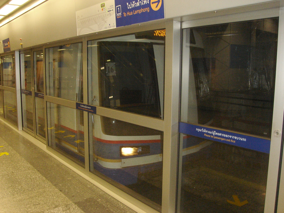
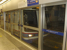 Platform screen door at all stations
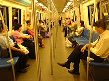 Inside of the train
The construction of the first Bangkok Metro line, officially known as Chaloem Ratchamongkhon (Thai สายเฉลิมรัชมงคล) – "Celebration of Royal Auspice" – or informally as the "Blue Line", began on 19 November 1996. The project suffered multiple delays not only because of the 1997 economic crisis, but also due to challenging civil engineering works of constructing massive underground structures deep in the water-logged soil upon which the city is built.
The Blue Line was opened for a limited public trial period of several weeks starting on 13 April 2004. On 3 July 2004 the line was officially opened at 19:19 local time by HM King Bhumibol and Queen Sirikit, who were accompanied by other members of the royal family. Within 30 minutes of its opening, sightseers filled the system to its maximum capacity, but after the initial rush ridership has settled down to around 180,000 riders daily — considerably lower than projections of over 400,000, despite fares being slashed in half from 12-38 baht to 10-15 baht per trip. From 2006 until 2008, fares ranged between 14-36 baht per trip. The fare was raised to 16-41 Baht on 1 January 2009.
Operation
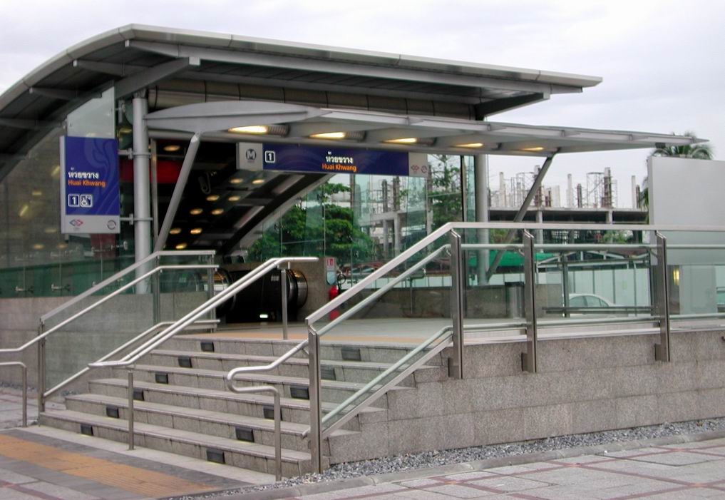
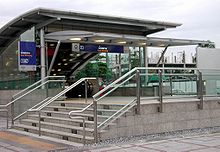 The entrance to Huai Khwang station
The 21-kilometer, 18-station Blue line presently runs from Bang Sue to Hua Lamphong via Phra Ram 9 and has a carrying capacity of 40,000 people in each direction per hour. Similar to the Skytrain, the Metro uses trains supplied by Siemens which travel up to 80 km/h. Passengers can conveniently connect to the Skytrain at Si Lom, Sukhumvit and Chatuchak Park stations. The metro has a large depot in Huai Khwang district, which is located between Phra Ram 9 and Thailand Cultural Centre stations.
Considering that Bangkok is a low-lying plain which is prone to flooding, all of the Metro's station entrances are raised about one metre above the ground level and are equipped with built-in floodgates in order to avoid water inundating the system. Lifts and ramps are found at all stations, providing easy access for passengers in wheelchairs. Stations have multiple passage ways (generally four) which allow passengers to connect to any corner of the adjacent surface intersection. Passageways between exits are very spacious and some are beginning to open as malls. Maps depicting the local area and exit points are posted on the walls on the way out.
Due to safety considerations, platform screen doors are installed. Uniformed security personnel and security cameras are present at each and every platform. Currently 19 three-car metro trains, of the Siemens Modular Metro type, are used. Each metro train consists of two motor cars and a centre trailer car.[1]
Ticketing
The ticketing system uses RFID contactless technology with round black tokens issued for single trips and contactless stored value cards for frequent travellers. In the near future, a joint ticketing system will be set up so that passengers can use a single ticket on the Metro as well as on the Skytrain. Multi-storey park & ride facilities are provided at Lat Phrao and Thailand Cultural Centre. Motorists who park their cars at these premises will be issued with additional contactless smartcards and they need to have them electronically stamped at their destination station. The turnstiles accept cards or paid for tokens, both available from from a booth or ticket machines, which do take notes. All luggage must be lifted above them when going through otherwise they sense the luggage going first as the paid for passenger and then the person carrying it is blocked.
There are one, three and thirty day cards. All are for unlimited travel and for that time only from first use. One day costs 100 baht, three day costs 280 baht and thirty days costs 1200 baht. At 40 baht per day, even when you do not need to use it, the thirty day pass is not very good value so most Thai people still pay per journey.
List of stations
Blue Line
In the table below, an italicized name indicates that the station is under construction and not yet in operation.
Code Station Name Transfer coordinates Blue Line Bang Sue-Tha Phra Extension (under construction[2]) Tha Phra (under construction) Terminal/Interchange
 MRT Blue Line: Hua Lamphong-Bang Khae Extension (under construction)
Charan Sanit Wong 13
(under construction)For Charansanitwong 13 neighbourhood, Thonburi Commercial Collage Yaek Fai Chai (under construction) For Bang Khun Si market, Nakhon Luang market, Phran Nok area Bang Khun Non
(under construction) MRT Orange Line (proposed)
 BMTA bus/taxi link to Taling Chan floating market, Southern Bus Terminal (Taling Chan)
Bang Yi Khan (under construction) BMTA bus/taxi link to Southern Bus Terminal (Taling Chan), CentralPlaza PinklaoSirindhorn (under construction)  SRT Light Red Line: Bang Bamru-Makkasan Extension (proposed)
For Krung Thon Bridge areaBang Phlat (under construction) For Bang Phlat District office Bang O (under construction) For Yanhee International Hospital Bang Pho (under construction)  Chao Phraya Express Boat : Bang Pho Pier
Tao Pun (under construction) MRT Purple Line (under construction)Hua Lamphong-Bang Sue 18
BANBang Sue Current terminal
SRT Dark Red Line (planned) : Bang Sue Junction
SRT Light Red Line (under construction) : Bang Sue Junction
Transfer
State Railway of Thailand Southern, Northern and Northeastern Lines (inter-city rails) : Bang Sue Junction13°48′8.75″N 100°32′27.36″E / 13.8024306°N 100.5409333°E 17
KAMKamphaeng Phet For Chatuchak Weekend Market and the market of Marketing Organization for Farmers (MOF market/Or Tor Kor market) 13°47′51.83″N 100°32′54.07″E / 13.7977306°N 100.5483528°E 16
CHAChatuchak Park Sukhumvit Line : Mo Chit with outdoor Park & Ride lot
BMTA bus/taxi link to Northern and Northeastern Bus Terminal (Mo Chit 2), Don Mueang and Rangsit suburbs
For Chatuchak Park, Chatuchak Weekend Market13°48′9.85″N 100°33′13.21″E / 13.8027361°N 100.5536694°E 15
PHAPhahon Yothin Sukhumvit Line: Saphan Mai Extension (planned) : Lat Phrao Intersection
For CentralPlaza Lardprao, Sofitel Centara Grand Hotel, International Civil Aviation Organization Thailand , Thai Airways International, Union Mall and PTT Public Company Limited
BMTA bus/taxi link to Kasetsart University, Meyo hospital, Saphan Mai market, northern suburbs of Bang Khen and Sai Mai13°48′46.25″N 100°33′41.22″E / 13.8128472°N 100.56145°E 14
LATLat Phrao BMTA bus/taxi link to the Department of Export Promotion Ministry of Commerce (Thailand), Chandrakasem Rajabhat University, Elephant Building, Major Cineplex Ratchayothin SCB Park Plaza, Criminal Court , Appeal Court , Civil Court , The Bangkok North Municipal Court, residental area along Lat Phrao Road13°48′23.21″N 100°34′22.54″E / 13.8064472°N 100.5729278°E 13
RATRatchadaphisek For Soi Choke Chai Ruam Mit, Olympia Thai Tower, The Travellers Hotel, Chaophaya Park Hotel, near Khlong Bang Sue[3] 13°47′56.58″N 100°34′28.37″E / 13.79905°N 100.5745472°E 12
SUTSutthisan For Muang Thai Patra Complex, Muang Thai Patra market, Golden Years Hospital, Sutthisan Police Station 13°47′24.12″N 100°34′27.02″E / 13.7900333°N 100.5741722°E 11
HUIHuai Khwang For Swissôtel Le Concorde, The Emarald Hotal, Huai Khwang market 13°46′43.13″N 100°34′26.64″E / 13.7786472°N 100.5740667°E 10
CULThailand Cultural Centre MRT Orange Line (proposed) with Park & Ride facility
For Embassy of The People's Republic of China in Thailand , Big C Extra Ratchadapisek and Robinson department stores, as well as the Esplanade Cineplex
About 20-minute walk (or taxi) to the performing-arts venue at Thailand Cultural Centre, Siam Niramit Theatre13°45′58.11″N 100°34′12.75″E / 13.7661417°N 100.5702083°E 9
RAMPhra Ram 9 For Fortune Town shopping center including a large Tesco Lotus store and IT mall, CentralPlaza Rama IX, at Phra Ram 9 intersection 13°45′26.57″N 100°33′54.56″E / 13.7573806°N 100.5651556°E 8
PETPhetchaburi Suvarnabhumi Airport Link : Makkasan (City Air Terminal)
SRT Light Red Line (proposed)
Khlong Saen Saep Express Boat : Asok Pier
For Srinakharinwirot University, Don Bosco School, Saint Dominic School, Rutnin Eye Hospital, Islamic Bank of Thailand13°44′56.90″N 100°33′48.20″E / 13.749139°N 100.563389°E 7
SUKSukhumvit Sukhumvit Line: Asok
For Siam Society, Asok and Sukhumvit business area13°44′15.36″N 100°33′40.91″E / 13.7376°N 100.5613639°E 6
SIRQueen Sirikit National Convention Centre For the Stock Exchange of Thailand, QSNCC and Khlong Toei Market 13°43′23.04″N 100°33′36.36″E / 13.7230667°N 100.5601°E 5
KHOKhlong Toei For Plai Nern Palace and Bon Kai market 13°43′20.57″N 100°33′14.26″E / 13.7223806°N 100.5539611°E 4
LUMLumphini For Suan Lum Night Bazaar, Lumpinee Boxing Stadium and Lumphini Park; Dropping point to Sathon and Wireless Road 13°43′32.07″N 100°32′45.10″E / 13.725575°N 100.545861°E 3
SILSi Lom Silom Line: Sala Daeng
For Lumphini Park, Chulalongkorn Hospital, Si Lom business area and Patpong night market13°43′45.44″N 100°32′15.21″E / 13.7292889°N 100.5375583°E 2
SAMSam Yan For Chulalongkorn University, Chamchuri Square, Snake Farm of the Thai Red Cross Society, Wat Hua Lamphong 13°43′55.49″N 100°31′50.76″E / 13.7320806°N 100.5307667°E 1
HUAHua Lamphong Current terminal
SRT Dark Red Line (proposed) : Hua Lamphong Railway Station
Transfer
State Railway of Thailand Southern, Eastern, Northern and Northeastern Lines (inter-city rails) : Hua Lamphong Railway Station
Chao Phraya Express Boat : Marine Department Pier (780 m from the station)
For Yaowarat Road (Chinatown), Golden Buddha, Wat Traimit13°44′14.17″N 100°31′4.05″E / 13.7372694°N 100.5177917°E Hua Lamphong-Bang Khae Extension (under construction[2]) Wat Mangkon (under construction) For Yaowarat Road (Bangkok's Chinatown), Wat Mangkon Kamalawat Wang Burapha (under construction) MRT Purple Line: Tao Pun-Rat Burana Extension (proposed)
For old quarter of Wang Burapha and Phahurat shopping sitesSanam Chai (under construction) For Pak Khlong Talat flower market, Memorial Bridge (Saphan Phut night market), Wat Pho, Wat Phra Kaew, and Museum Siam (National Discovery Museum) Itsaraphap (under construction) For Wat Arun and Bangkok Yai neighbourhood Tha Phra (under construction) Interchange
MRT Blue Line: Bang Sue-Tha Phra Extension (under construction)
For Tha Phra intersection neighbourhood, Wat Tha Phra, Bangkok Yai District officeBang Phai (under construction) For Bang Phai neighbourhood Bang Wa (under construction) Silom Line: Bang Wa Extension (under construction) : Bang Wa
For Siam UniversityPhetchakasem 48 (under construction) Phasi Charoen (under construction) For Seacon Square Bangkae shopping mall Bang Khae (under construction) For Bang Khae market Lak Song (under construction) Terminal at Kanchanaphisek Outer Ring Road with park & ride facilities
BMTA bus/taxi link to Nong Khaem western suburb and Nakhon Pathom Province
For The Mall Shopping Center BangkaeExpansion plans
Blue Line Overview System Bangkok Metro (MRT) Status 18 stations built and extension of 21 stations is under construction. Locale Bangkok, Thailand Termini Hua Lamphong
Bang SueStations 18 Operation Character Underground/Elevated Technical Line length 27 km (16.78 mi) Various expansion plans of the Metro have been proposed. As of 2011[update], the MRT Purple Line and the two extension lines of the blue line are also under construction. It is planned that, eventually, the combined route distance of the Metro alone will total 91 km with 3 Metro lines covering all of the major areas of Bangkok. The Blue line, once completely extended, will form a lariat-shaped loop encircling the city.
Extension of the blue line can be summarised as follows:
- Blue Line extension[4]:
- Bang Sue – Bang Phlat – Tha Phra (13 km) (under construction operational in 2015)
- Hua Lamphong – Tha Phra – Bang Khae (14 km) (under construction operational in 2015)
- Purple Line: Bang Yai – Sam Sen – Rat Burana (40 km)
- Bang Sue - Bang Yai northern section (under construction operational in 2013).
- Bang Sue - Kiak Kai extension (serving the new parliament complex; planned).
- Kiak Kai - Wang Burapha section (underground; planned).
- Wang Burapha - Rat Burana southern section (underground / elevated; planned).
- Orange Line: Bang Kapi – Dindaeng – Taling Chan (37.5 km, Change from Bang Kapi – Sam Sen – Bang Bamru)
Other expansion plans for the metro include:
- Yellow Line: Lat Phrao – Sri Nagarindra – Samut Prakan
- Pink Line:Saen Saep – Ram-Inthra Rd. – Chaeng Watthana Road – Tiwanon-Ngamwongwan Road intersection. (35 km)
[Note] that these plans do not include the extension proposed for the Skytrain, SRT Lines and airport link which is under the control of BMA and State Railway Thailand. BMCL itself expects to be the operator for the extension project and other lines but the final decision is still dependent on MRTA (government sector).[citation needed]
As per the BMCL's annual report, earning of profit from operation is still far away and BMCL is still subsidized by main share holder which is CH Karnchange. An accumulated deficit from now is estimated between 1,000 and 1,500 Million baht.[citation needed] Nevertheless, the deficit is partially mitigated by initial public offering and the earning per share is still giving with no hope to public share holder from now.[citation needed]
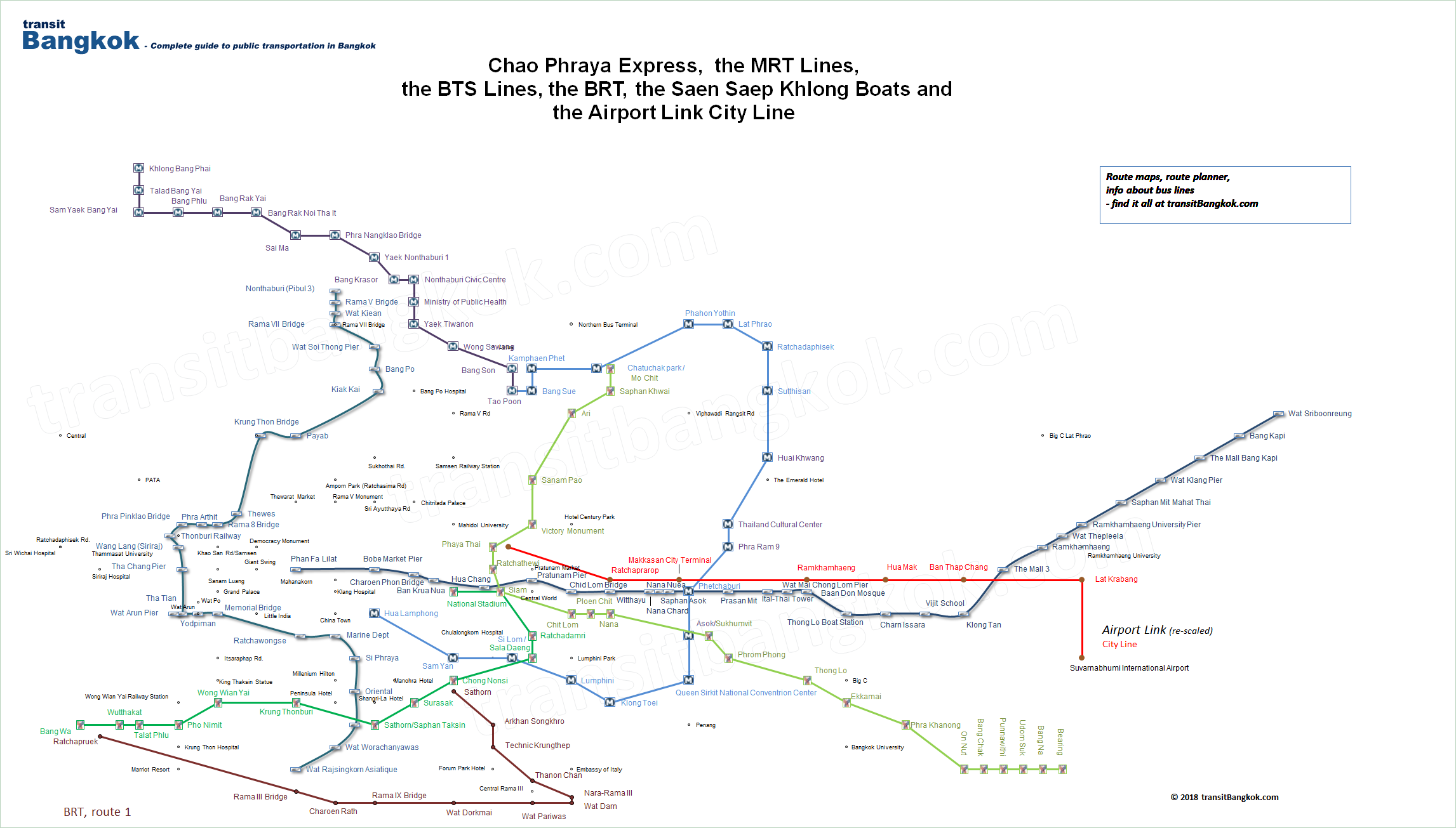
Connectivity to other rail transit systems
Bangkok rail transit system map (showing State Railway, BTS, MRT and SARL lines) Legend( State Railway Northern & Northeastern Lines )
( State Railway Southern Line )

Bang Sue Junction / Bang Sue MRT 


Kamphaeng Phet Pradiphat 


Mo Chit / Chatuchak Park Samsen 

Saphan Khwai / Phahon Yothin Chitralada Palace (not in service) 

Sena Ruam (planned) / Lat Phrao Yommarat Ari / Ratchadaphisek 

Sanam Pao / Sutthisan 

Victory Monument / Huai Khwang ( State Railway Eastern Line )


Phaya Thai BTS / Phaya Thai SARL / Thailand Cultural Centre Bangkok (Hua Lamphong) / National Stadium 
Ratchathewi / Ratchaprarop / Phra Ram 9 Hua Lamphong / Siam 


Makkasan / Phetchaburi Sam Yan / Ratchadamri 


Ramkhamhaeng Sala Daeng / Si Lom 
Chit Lom / Hua Mak Chong Nonsi / Lumphini Phloen Chit / Ban Thap Chang Sueksa Witthaya (planned) / Khlong Toei Nana / Lat Krabang Surasak / QSNCC 
Asok / Sukhumvit Sathon Pier Saphan Taksin 


Suvarnabhumi Airport Taksin Bridge 
Phrom Phong Krung Thonburi Thong Lo Wongwian Yai 
Ekkamai Phra Khanong On Nut Bang Chak Punnawithi Udom Suk Bang Na Bearing Major accident record
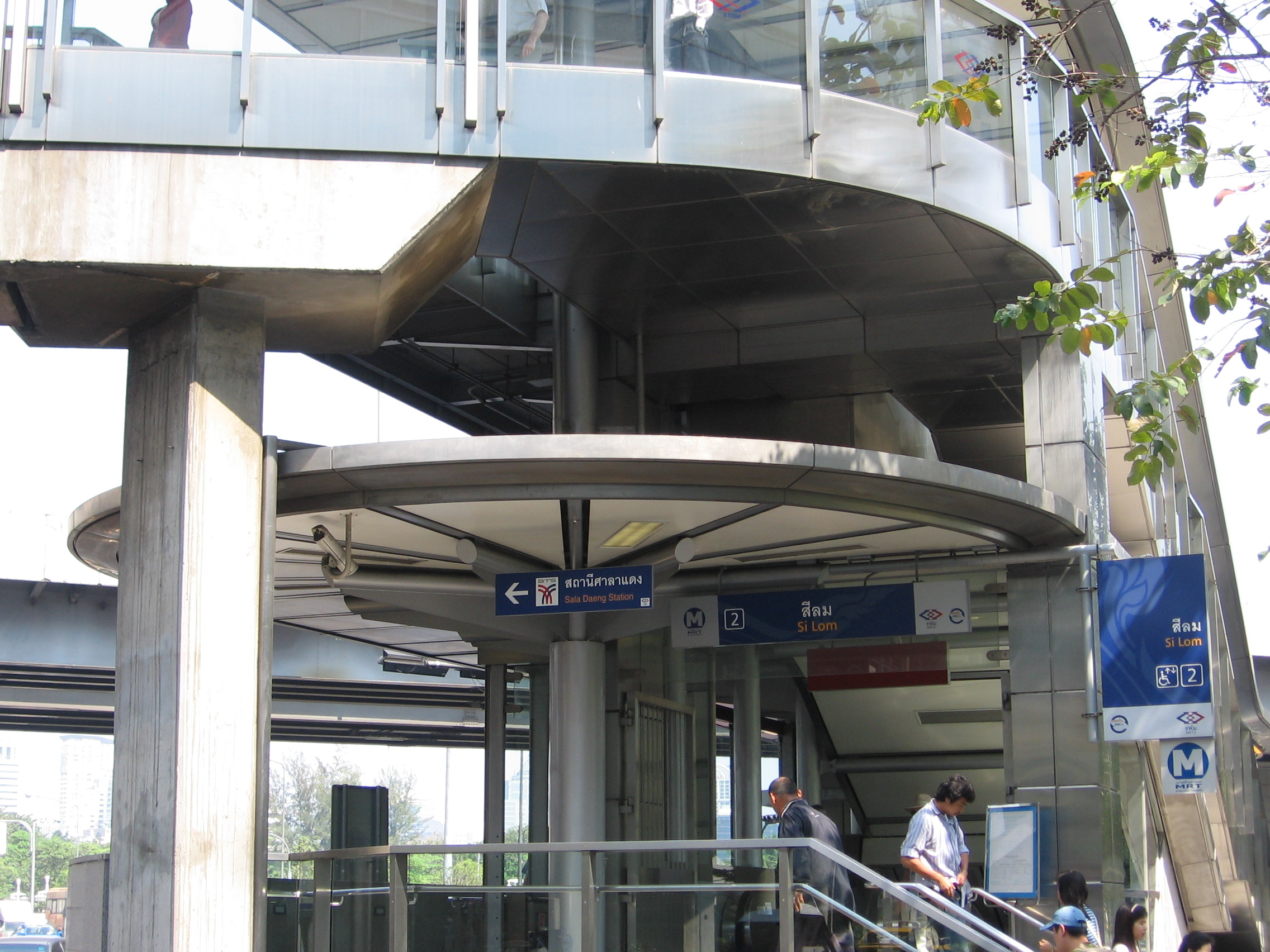
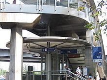 Entrance to Silom Station (Interchange with BTS Sala Daeng Station)
On 17 January 2005, just after 09:15, an empty train returning to the depot collided with a peak-hour train filled with passengers at the Thailand Cultural Centre station. 140 people were hurt, most of whom sustained only minor injuries, and the entire Metro network was shut down for two weeks.
After initial investigations, it was found that the empty train had run into problems shortly before the accident, grinding to a halt on a curve leading to the depot. The driver applied its brake and was waiting to be towed to the maintenance centre close to Thailand Cultural Centre station.
A rescue train was attempting to connect to the stalled train when the driver was told to release the brake while coupling had not yet been successful. It was then that the empty train began to roll backwards at a speed of ten metres per second, before smashing into the other train, which was carrying passengers. Therefore, it was believed that the incident was caused by negligence due to insufficient training of operation staff.[5] This accident also resulted in two damaged trains with heavily damaged areas limited to the two leading cars. The colliding speed was suspected to be about 60 km/h due to the appearance of damaged areas. However, one train, which was rebuilt from the repair of the minor-damaged cars, was already fitted for operation at the end of 2006 and the remaining one was still under heavy repair until mid of 2007; it was released into service in October, 2007. The cost resulting from the accident might be a much higher figure than BMCL quoted, and it was expected to be at least 400 million baht, which was totally insured by a local insurance company.
The Metro resumed full operation on 1 February 2005, and passenger numbers soon rose back to pre-crash levels, partly due to a temporary promotional fare scheme which allowed passengers to travel any distance on the MRT for only ten baht (~0.33 USD).
See also
Bangkok Rapid Transit System Primary lines BTS Sukhumvit Line (extension planned) BTS Silom Line (extension under construction) MRT Blue Line (extension under construction) SRT Airport Rail Link MRT Purple Line (under construction) SRT Light Red Line (under construction) SRT Dark Red Line (planned) MRT Orange Line (planned) MRT Yellow Line (planned) Secondary lines Chula-Siam Monorail (planned) Grand Square Monorail (planned) Ramkhamhaeng-Thonglor Monorail (planned) MRT Pink Line (planned) BTS Bang Na-Suvarnabhumi (planned) Cancelled projects MRT Brown Line (merged with orange line) MRT Grey Line (cancelled) MRT Light Blue Line (cancelled) Bangkok Elevated Road and Train System (cancelled) Lavalin Skytrain (cancelled) - List of rapid transit systems
- Bangkok Skytrain
- BRT (Bangkok)
- SRT Lines
- Suvarnabhumi Airport Link
References
- ^ "Bangkok's first underground metro open". International Railway Journal. findarticles.com. July, 2004. http://findarticles.com/p/articles/mi_m0BQQ/is_7_44/ai_n6131837. Retrieved 2008-08-30.
- ^ a b http://www.nationmultimedia.com/2011/02/18/business/Seven-deals-move-Blue-Line-extension-closer-30148981.html
- ^ http://www.panoramio.com/photo/31795302
- ^ www.nationmultimedia.com/2011/02/18/business/Seven-deals-move-Blue-Line-extension-closer-30148981.html
- ^ "Thai subway shut for safety probe". BBC News. 17 January 2005. http://news.bbc.co.uk/2/hi/asia-pacific/4180109.stm. Retrieved 13 May 2010.
External links
Official sites
- Mass Rapid Transit Authority of Thailand
- Bangkok MRT Master Plan - Office of Transport and Traffic Policy Planning
- Bangkok Metro Company Limited
Unofficial sites
- Bangkok subway history at 2bangkok.com
- MRT Site at Transit Bangkok
- Bangkok Mass Transit
- The Modern Rail Based Mass Transit of Thailand (MRT and BTS photos)
- Unofficial Technical Data
Downloads
- Download a map of MRT, BTS, Khlong boats and Chao Phraya Express
- Download the System Map of Bangkok Rail Transit Network in PDF format
- Download the Master Plan of Bangkok Transport Network in PDF format (includes proposed extensions)
Public transport systems in Bangkok Rapid transit BTS Skytrain · Bangkok Metro (MRT) · Suvarnabhumi Airport Link · Bangkok BRT · Chula-Siam Monorail · Ramkhamhaeng-Thonglor Monorail · BMA2-Soi Yothin Monorail · Bang Na-Suvarnabhumi LRTBuses Buses in Bangkok (BMTA)Water buses Bangkok Boat Express Lines ( Chao Phraya Express Boat ·
  Khlong Saen Saep Express Boat ·
  Sathon-Klong Toei Express Boat ·
  Golden Mount Line ·
  NIDA Line ·
  Bangkok Noi Longtail Express Boat ·
  Sathon-Wat Dao Khanong Express Boat ·
  Sathon-Samut Prakan Express Boat ·
  Khlong Phasi Charoen Express Boat ·
  Khlong Lat Phrao Express Boat ·
  Khlong Prem Prachakhon Express Boat ·
  Khlong Phadung Krung Kasem Express Boat)Categories:
- Bangkok Metro
- Transport in Bangkok
- Rapid transit in Thailand
- Underground rapid transit in Thailand

Wikimedia Foundation. 2010.