- Maneri Dam
-
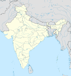
Maneri Dam Location of Maneri Dam Country India Location Uttarkashi Coordinates 30°44′21″N 78°31′43″E / 30.73917°N 78.52861°ECoordinates: 30°44′21″N 78°31′43″E / 30.73917°N 78.52861°E Status Operational Owner(s) Uttarakhand Jal Vidyut Nigam Limited Dam and spillways Type of dam Gravity Height 39 m (128 ft) Length 127 m (417 ft) Volume 13,700 m3 (17,919 cu yd) Impounds Bhagirathi River Spillway capacity 5,000 m3/s (176,573 cu ft/s) Reservoir Capacity 600,000 m3 (486 acre·ft) Active capacity 510,000 m3 (413 acre·ft) Surface area 1.8 km2 (1 sq mi) Power station Commission date 1984 Turbines 3 x 30 MW Francis-type Installed capacity 90 MW The Maneri Dam is a concrete gravity dam on the Bhagirathi River located at Maneri, 8.5 km (5 mi) east of Uttarkashi in Uttarkashi district, Uttarakhand, India. The primary purpose of the dam is to divert water into a tunnel which feeds the 90 MW run-of-the-river Tiloth Power Plant.
Contents
Background
The power station is stage one of the Maneri Bhali Hydroelectric Project which was planned in the 1960s. It was completed and commissioned in 1984. Dharasu Power Station, the second stage, was halted in 1990 due to funding issues and was not restarted until 2002.[1] It was eventually completed and commissioned by 2008.[2]
Design and operation
The Maneri Dam is a 39 m (128 ft) tall and 127 m (417 ft) wide gravity dam with a structural volume of 13,700 m3 (17,919 cu yd). It's spillway is located on its crest and is controlled by four tainter gates. In addition to discharge tunnel, the spillway has a maximum discharge capacity of 5,000 m3/s (176,573 cu ft/s). The dam's reservoir has a 600,000 m3 (486 acre·ft) capacity, of which 510,000 m3 (413 acre·ft) is active (or "useful") capacity.[3] Water supplied to the power station is first diverted from the Bhagirathi River by the dam into a 8.6 km (5 mi) long tunnel directly behind the dam. The difference in elevation between the barrage and the power station affords a design hydraulic head of 147.5 m (484 ft) and gross head of 180 m (591 ft). Near the Tiloth Power Plant at 30°43′36″N 78°26′44″E / 30.72667°N 78.44556°E, the tunnel splits into three penstocks to power each of the three 30 MW Francis turbine-generators before being discharged back into the river. The design discharge of the power station is 71.4 m3/s (2,521 cu ft/s).[4]
See also
- List of power stations in India
References
- ^ "Power from Maneri Bhali by year-end". Outlook India. 12 March 2006. http://www.euttaranchal.com/news/general/power-from-maneri-bhali-by-year-end.html. Retrieved 11 July 2011.
- ^ "Dharasu HEP (4x76=304 MW)". Uttaranchal Jal Vidyut Nigam Limited. http://www.uttarakhandjalvidyut.com/MB%20Stage-II/MB-II.htm. Retrieved 11 July 2011.
- ^ "India: National Register of Large Dams 2009". Central Water Commission. http://www.cwc.nic.in/main/downloads/National%20Register%20of%20Large%20Dams%202009.pdf. Retrieved 10 July 2011.
- ^ "Maneri Bhali Stage-I (Tiloth) Power Plant (3x30=90 MW)". Uttarakhand Jal Vidyut Nigam Limited. http://www.uttarakhandjalvidyut.com/tiloth.htm. Retrieved 12 July 2011.
Hydrology of Uttarakhand Rivers Lakes Dams/ Barrages Asan Barrage • Bhali Dam • Bhimgoda Barrage • Dakpathar Barrage • Ichari Dam • Koteshwar Dam • Maneri Dam • Pashulok Barrage • Ramganga Dam • Tehri DamGlaciers Gangotri • Kafni • Kalabaland • Meola • Milam • Namik • Panchchuli • Pindari • Ralam • Satopanth • SonaRelated topics GomukhCategories:- Dams in Uttarakhand
- Hydroelectric power stations in Uttarakhand
- Run-of-the-river power stations
- Gravity dams
- Uttarkashi district
Wikimedia Foundation. 2010.

