- Malinao Volcano
-
Malinao Volcano Buhi or Takit Volcano 
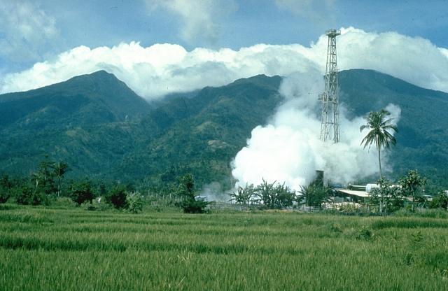
Mount Malinao with Tiwi Geothermal Field in the foregroundElevation 1,548 m (5,079 ft) [1] Prominence 1,548 m (5,079 ft) Listing Potentially active volcanoes of the Philippines Location Location in the Philippines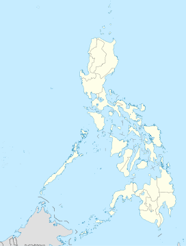
 Malinao Volcano
Location Luzon Philippines Coordinates 13°24′58″N 123°36′30″E / 13.41611°N 123.60833°ECoordinates: 13°24′58″N 123°36′30″E / 13.41611°N 123.60833°E Geology Type stratovolcano Age of rock Quaternary Volcanic arc/belt Bicol Volcanic Chain Last eruption Unknown Malinao is a volcano located in the Bicol Region of the Philippines. The stratovolcano has no historical eruption but displays strong fumarolic activity which is harnessed for generating electricity. Located on its slope is Tiwi Geothermal Power Plant, one of the first geothermal energy plant commissioned in the country.[2]
Contents
Location
Malinao Volcano is situated between the provinces of Albay and Camarines Sur in the southeastern region of Luzon Island; about 20 km (12 mi) north-northwest of Mayon volcano, the most active volcano in the Philippines.
Physical features
The mountain is forested with an elevation of 1,548 metres (5,079 ft) asl and a base diameter of 22.5 kilometres (14.0 mi). On the summit of the volcano is a large crater with bare inner walls that is breached on the eastern side. On the lower flank this side of the predominantly andesitic volcano, is Luzon's largest solfataras and hot springs, some of which deposit silicious sinter. Naglagbong and Jigabo are two thermal wells located on the volcano. Temperatures up to 108 °C (226 °F) were recorded on the fumaroles of Naglagbong.[1][3][4]
Tiwi Geothermal Power Plant
This area was one of the first studied for generating electricity starting with a 250kW power plant in 1967.[5] In 1979, the first of the three 110 MW geothermal power plant was commissioned that year; the other two, in 1980 and 1982. At its peak, the plant was producing a maximum of 330 MW output. Recently, the 1979 plant was decommissioned due to decrease in steam supply.[6][7]
Classification
The Philippine Institute of Volcanology and Seismology (PHIVOLCS), the government bureau that deals with volcanism in the country classifies Malinao as a potentially active volcano.[8]
Eruptions & activities
There are no historical eruptions from Malinao which is believed to have been active from about 500,000 years ago until 60,000 years ago.[1]
1970 earthquake swarms
There was an increase in seismicity in 1970 accompanied by rumbling noises in Malinao prompting an issue of warning that the mountain might be reactivating. The tremors detected were ranging from 1 to 5 in intensity.[3]
Small explosion in 1980
There was a minor phreatic explosion in the Naglagbong pool area in Tiwi on July 29, 1980, ejecting mud and rocks up to 2⁄3 metres (2 ft 2 in), reaching 150 metres (490 ft) in height and distances up to 350 metres (1,150 ft). One person was injured and two buildings were damaged by the explosion. Prior to the event, as early as July 6, the area was experiencing unusual microseisms recorded at seismic station of the Commision on Volcanology (COMVOL) - the predecessor of PHIVOLCS - in the area. Geysering was also observed on the pool, two hours before the explosion. One theory about the cause of the explosion was water drawdown during the development of the Tiwi geothermal field.[3]
See also
- Active volcanoes in the Philippines
- Potentially active volcanoes in the Philippines
- Inactive volcanoes in the Philippines
- Pacific ring of fire
References
- ^ a b c "Malinao - Summary". Smithsonian Institution's Global Volcanism Program.
- ^ (2009-01-20). "The Tiwi Geothermal Power Plant". JCMiras.net. Retrieved on 2011-09-24.
- ^ a b c "Seismic and geothermal activity at Malinao". Smithsonian Institution's Global Volcanism Program. Retrieved on 2011-09-24.
- ^ "Malinao". Philippine Institute of Volcanology and Seismology. Retrieved on 2011-09-24.
- ^ (2009-01-20). "The History of Geothermal Energy Development and Production in the Philippines". JCMiras.net. Retrieved on 2011-09-24.
- ^ (2008-06-17). "Geothermal Power Plants in the Philippines.. JCMiras.net. Retrieved on 2011-09-24.
- ^ (2008-02-24). "Geothermal Energy Resources in the Philippines". JCMiras.net. Retrieved on 2011-09-24.
- ^ Philippine Institute of Volcanology and Seismology (PHIVOLCS), Potentially Active Volcanoes page
External links
Categories:- Stratovolcanoes
- Subduction volcanoes
- Volcanoes of Luzon
- Mountains of the Philippines
- Landmarks in the Philippines
- Albay
- Camarines Sur
- Potentially active volcanoes of the Philippines

Wikimedia Foundation. 2010.