- Second East–West Highway
-
Federal Route 185
Second East-West Highway Route information Length: 313.6 km (194.9 mi) Existed: 2001 – present History: Completed in 2004 Major junctions West end: Simpang Pulai, Perak  Federal Route 1
 Federal Route 59
 Federal Route 8
East end: Kuala Berang, Terengganu Location Primary
destinations:Ipoh
Cameron Highlands
Kota Bharu
Kuala Lipis
Gua Musang
Kenyir Lake
Kuala TerengganuHighway system Second East-West Highway, Federal Route
 (Malay: Lebuhraya Timur-Barat Kedua) is a highway in Peninsular Malaysia which connects Simpang Pulai in Perak to Gua Musang in Kelantan. The highway is expected to be extended further east to Kuala Terengganu in the future. This highway features a four-lane carriageway from Simpang Pulai to Cameron Highlands and a two-lane carriageway from Cameron Highlands to Gua Musang. It is notorious for its many sharp corners which increase the risk of road accidents.
Contents
Route background
The Kilometre Zero of the Federal Route 185 is located at Simpang Pulai, Perak, at its junctions with the Federal Route
, the main trunk road of the central of Peninsular Malaysia.History
The highway was formerly known as Perak State Route
A181 from Simpang Pulai to Pos Slim before being extended eastwards and recommissioned as a federal highway. The construction of the highway began in 2001 and was completed in 2004. Phase 2 should be completed by end 2010.
Location of the project
The proposed route runs through the states of Perak, Pahang, Kelantan and Terengganu, starting at Simpang Pulai and traversing through the main range at Lojing, and ending at Kuala Berang.
Project scope of work
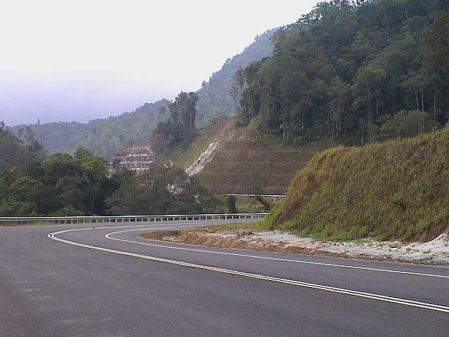
 Second East-West Highway near Cameron Highlands.
The total distance of the proposed road is 313.66 km (194.90 mi), excluding the 41 km (-- miles) existing road from Gua Musang to Chiku, Kelantan. The road is designed to Malaysian Public Works Department (JKR) geometric standard of R3 with a design speed of 50 km/h (-- mph).
In terms of riding comfort, this R3 standard falls in between the R5 or R6 standard for expressway (typically with a design speed of 80-110 km/h (-- mph)) and R1 or R2 standard such as the winding hilly road (typically with a design speed of 20-30 km/h (-- mph)).
Typically, the road is a two-lane single carriageway with a lane width of 3.5m (-- ft) and shoulder width of 2.5m (-- ft). Climbing lanes are also provided at certain sections with steep gradient, to assist slow moving vehicles. The project also involves the construction of viaducts, bridges and culverts.
Estimated cost
The entire project is estimated to cost RM1.6 billion and divided into 10 packages for implementation
Features
Notable features
At most section, the Federal Route 185 was built under the JKR R5 road standard, allowing maximum speed limit of up to 90 km/h.
Overlaps
Alternate routes
Sections with motorcycle lanes
Notable events
- 20 December, 2010 – Twenty-seven people, mostly Thai tourist were killed when the double-decked coach bus they were travelling in crashed at the Second East-West Highway of the Perak-Pahang border near Cameron Highlands, Pahang.
List of Junctions and Towns
This is a list of junctions and towns along the highway.
Km Exit Junctions To Remarks
0SIMPANG PULAI NORTH
Ipoh
SOUTH
 Batu Gajah
Gopeng

 AH2 NORTH-SOUTH EXPRESSWAY NORTHERN ROUTE
Bukit Kayu Hitam
Penang
Kuala LumpurT-Junctions SECOND EAST-WEST HIGHWAY (Phase 1)
Simpang Pulai-Gua Musang
Start/End of highway--- m above sea level Start/End of six-lane carriageway Kampung Raja
--- m above sea level
15--- m above sea level Perak Darul Ridzuan
Kinta district borderPerak-Pahang border
--- m above sea levelPahang Darul Makmur
Cameron Highlands district borderCAMERON HIGHLANDS (North)
--- m above sea levelSOUTH
Cameron Highlands
BrinchangT-Junctions --- m above sea level Start/End of six-lane carriageway --- m above sea level Start/End of single carriageway Pahang Darul Makmur
Cameron Highlands district borderPahang-Kelantan border
--- m above sea levelKelantan Darul Naim
Gua Musang district borderPos Sigar
--- m above sea levelPos Sigar Orang Asli village T-junctions Pos Brooke
--- m above sea levelPos Brooke Orang Asli village T-junctions Pos Mering
--- m above sea levelPos Mering Orang Asli village
Lojing HighlandsT-junctions Lojing
--- m above sea levelLojing Highlands T-junctions Sungai Berok bridge
--- m above sea levelKampung Sungkai
--- m above sea levelJalan Ulu Nenggiri
--- m above sea levelWEST
D30 JALAN ULU NENGGIRI
Ulu Nenggiri
Kampung PiltingT-junctions SECOND EAST-WEST HIGHWAY (Phase 1)
Simpang Pulai-Gua MusangGUA MUSANG NORTH
D29 JALAN DABONG-GUA MUSANG
Dabong
Jeli
SOUTH
Kuala Lipis
 Jerantut
Taman Negara
RaubJunctions Chiku NORTH
Kota Bharu
Kuala KraiT-junctions SECOND EAST-WEST HIGHWAY (Phase 2)
Gua Musang-Kuala Berang
Under constructionKampung Kabang
--- m above sea levelSungai Lebir bridge
--- m above sea levelKampung Lanchang
--- m above sea levelKelantan Darul Naim
Gua Musang district borderKelantan-Terengganu border
--- m above sea levelTerengganu Darul Iman
Hulu Terengganu district borderSungai Kembur Viaduct
--- m above sea levelSungai Kelempai Viaduct
--- m above sea levelSungai Purun Viaduct
--- m above sea levelPasir Pulau Bridge
Kenyir Lake
--- m above sea levelKenyir Lake
Pasir Pulau
--- m above sea levelKenyir Lake SECOND EAST-WEST HIGHWAY (Phase 2)
Gua Musang-Kuala Berang
Under constructionKUALA BERANG SOUTH
 Kuala Berang
T-junctions EAST
Bukit Payong
Kuala Terengganu
 EAST COAST EXPRESSWAY
Kota Bharu
Besut
Kuala Lumpur
KuantanSee also
 Malaysian Federal Roads System
Main Federal Roads
(Peninsula Malaysia)1 2 3 4 5 6 7 8 9 10 11 12 13 14 15 16 17 18 19 20 23 24 26 27 28 29 30 31 32 33 50 51 53 54 55 56 57 58 59 60 61 62 63 64 65 66 67 68 69 70 71 72 73 74 75 76 77 78 79 80 81 82 83 84 85 86 87 88 89 90 91 92 93 94 95 96 97 98 99 100 101 102 103 104 105 106 107 108 109 110 111 112 113 114 115 116 117 118 119 120 121 122 123 124 125 126 127 128 129 130 131 132 133 134 135 136 137 138 139 140 141 142 143 144 145 146 147 148 149 150 151 152 153 154 155 156 157 158 159 160 161 162 163 164 165 166 167 168 169 170 171 172 173 174 175 176 177 178 179 180 181 182 183 184 185 186 187 188 189 190 191 192 193 194 195 196 197 198 199 200 201 202 203 204 205 206 207 208 209 210 211 212 213 214 215 216 217 218 219 220 221 222 223 225 228 231 2A 2B
FELDA/FELCRA Federal Roads
(Peninsula Malaysia)Industrial Federal Roads
(Peninsula Malaysia)Institutional Facilities Federal Roads
(Peninsula Malaysia)Main Federal Roads
(Sarawak)1 1-1 1-2 1-3 1-4 1-5 1-6 1-7 1-8 1-9 1-10 1-11 1-12 1-13 1-14 1-15 1-16 1-17 1-18 1-19 1-20 1-21 1-22 1-23 1-24 1-25 1-26 1-27 1-28 1-29 1-30 1-31 1-32 1-33 1-34 1-35 1-36 1-37 1-38 1-39 1-40 1-41 1-42 1-43 1-44 1-45 1-46 1-47 1-48 1-49 1-50 1-51 1-52 1-53 1-54 1-55 1-56 1-57 1-58 1-59 1-60 1-61 1-62 1-63 1-64 1-65 1-66 1-67 1-68 1-69 1-70 1-71 1-72 1-73 1-74 1-75 1-76 1-77 1-78 1-79 1-80 1-81 1-82 1-83 1-84 1-85 1-86 1-87 1-88 1-89 1-90 1-91 1-92Other Federal Roads
(Sarawak)Main Federal Roads
(Sabah)Main Federal Roads
(Labuan)700 701 702 703 704 705 706 707 708 709 710 711 712 713 714 715 716 717 718 719 720 721 722 723 724 725 726 728 729 730 731ECER Kelantan Gua Musang • Kota Bharu • Pengkalan Chepa • Rantau Panjang • Second East-West Highway • Sultan Ismail Petra Airport • Taman Negara • University of Malaysia KelantanECER Terengganu Bandar Al-Muktafi Billah Shah • Bandar Chenih Bahru • Bandar Ketengah Jaya • Islamic Heritage Park • Kenyir Lake • Kuala Terengganu • Paka • Perhentian Islands • Rantau Abang • Redang Island • Kerteh • Kemaman • East Coast Expressway • Second East-West Highway • Sultan Mahmud Airport • University of Malaysia Terengganu • Taman NegaraECER Pahang Bandar Indera Mahkota • Bandar Muadzam Shah • Bandar Pusat Jengka • Bandar Tun Abdul Razak • Bera Lake • Chini Lake • Cherating • East Coast Expressway • Gambang • Gebeng • Genting Highlands • Jerantut • Kuantan • Kuantan Port • Pekan • Sultan Haji Ahmad Shah Airport • Tioman Island • University of Malaysia Pahang • Taman NegaraECER Johor Categories:- Highways in Malaysia
- Malaysian Federal Roads


Wikimedia Foundation. 2010.