- Mahuli
-
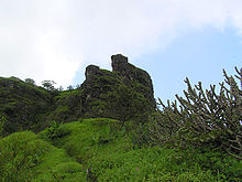 Mahuli fort pinnacle
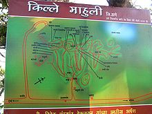 Map of Mahuli and surrounding area at Mahuli
Mahuli Fort At 2815 ft., this is a sought after trekking destination.
It is the highest point in the Thane district. The forest surrounding Mahuli has been declared as a sanctuary. Once Shahaji Raje, father of Chatrapati Shivaji Maharaj, had this fortress under his belt.
The nearest railway station to Mahuli is Asangaon. One can catch either Asangaon or Kasara Local from Mumbai CST, which could also be caught at Kalyan Junction. 4 km walk from Asangaon station will take you to the base temple in 1-1/2 hours. 3 hours trek will take you to the summit.
Reaching there
Asangaon on Mumbai-Nashik highway (91) km from Mumbai. 5 km inside on to the left is the Mahuli village.
History
The creator of this fort is unknown. In 1485 this place came under rule Nijamshahi dynasty. When Shahaji Raje became the secretary of Nijamshahi, Mughals of Delhi tried to end Nijamshahi. In 1635-36, Shahaji Raje transferred himself with Jijabai and Shivaji to Mahuli. When Khan Jaman attacked the fort, Shahaji asked Portuguese for help, who refused and Shahaji surrendered.
Shivaji took this fort from Mughals on 8 Jan 1658. In 1661 it was given back and was won again by Shivaji. In treaty of Purandar, in 1665, Marathas lost these forts again. In Feb 1670, Shivaji Maharaj tried to conquer Mahuli, but failed, Manohardas Gaud, was the in charge of the fort. A thousand Marathas were killed.Most of them were from nearby villages.Shivaji Maharaj said to his dead kadam sardar he is our gold. So maharaj gave sonare surname to this family. Manohardas Gaud, soon gave up his position and Alveerdi Beg took over. On 16 June 1670, after two months, Moropant Pingle conquered the forts and Mahuli, Bhandargad and Palasgad became part of Swarajya. Till 1817, Shivaji's dynasty owned the fort but later on it was controlled by the British Raj.
Forts in Maharashtra Akola district Akola Fort · Narnala · BalapurSatara district Mumbai suburban district Mumbai city district Bombay Castle · Dongri Fort · Fort George · Mahim Fort · Mazagon Fort · Riwa Fort · Sewri Fort · Sion Hillock Fort · Worli FortRaigad district Karnala · Korlai · Kothaligad · Kolaba Fort · Lingana · Manikgad · Murud-Janjira · Padmadurg · Raigad · Sudhagad · Malanggad · Khanderi · Underi · Prabalgad · IrshalgadAurangabad District Amravati district Ahmednagar district Ratnagiri district Pune district Nashik district Kolhapur district Sindhudurg district Sindhudurg · VijaydurgNagpur district SitabuldiDhule district Laling · ThalnerThane district Bassein Fort · Belapur Fort · Arnala · Ghodbunder Fort · Mahuli
Categories:- Forts in Maharashtra


Wikimedia Foundation. 2010.