- Mae Lan District
-
Mae Lan
แม่ลาน— Amphoe — Amphoe location in Pattani Province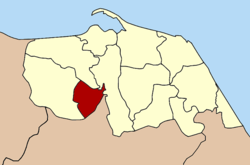
Coordinates: 6°39′39″N 101°14′23″E / 6.66083°N 101.23972°ECoordinates: 6°39′39″N 101°14′23″E / 6.66083°N 101.23972°E Country  Thailand
Province Pattani Seat Mae Lan Tambon Muban Amphoe established Area - Total 89.2 km2 (34.4 sq mi) Population (2005) - Total 14,863 - Density 166.6/km2 (431.5/sq mi) Time zone THA (UTC+7) Postal code 94180 Geocode 9411 Mae Lan (Thai: แม่ลาน) is a district (Amphoe) of Pattani Province, southern Thailand.
Contents
History
The minor district (king amphoe) Mae Lan was formed on April 1 1989 by splitting off three tambon from Khok Pho district.[1] Becoming effective of September 7 1995 it was upgraded to a full district.[2]
Geography
Neighboring districts are (from the west clockwise) Khok Pho, Nong Chik and Yarang of Pattani Province, and Mueang Yala of Yala Province.
Administration
The district is subdivided into 3 subdistricts (tambon), which are further subdivided into 22 villages (muban). There are no municipal (thesaban) areas, and 3 Tambon administrative organizations (TAO).
No. Name Thai name Villages Inh. 1. Mae Lan แม่ลาน 8 3,682 2. Muang Tia ม่วงเตี้ย 9 5,436 3. Pa Rai ป่าไร่ 10 5,745 References
- ^ "ประกาศกระทรวงมหาดไทย เรื่อง แบ่งท้องที่อำเภอโคกโพธิ์ จังหวัดปัตตานี ตั้งเป็นกิ่งอำเภอแม่ลาน" (in Thai). Royal Gazette 106 (40 ง): 1888. March 14 1989. http://www.ratchakitcha.soc.go.th/DATA/PDF/2532/D/040/1888.PDF.
- ^ "พระราชกฤษฎีกาตั้งอำเภอด่านมะขามเตี้ย อำเภอแก่งหางแมว อำเภอภักดีชุมพล อำเภอเวียงแก่น อำเภอแม่วาง อำเภอถ้ำพรรณรา อำเภอบ่อเกลือ อำเภอโนนสุวรรณ อำเภอห้วยราช อำเภอแม่ลาน อำเภอบางแก้ว อำเภอป่าพะยอม อำเภอหนองม่วงไข่ อำเภอยางสีสุราช อำเภอจังหาร อำเภอบ้านธิ อำเภอภูสิงห์ อำเภอบางกล่ำ อำเภอวังม่วง และอำเภอนายูง พ.ศ. ๒๕๓๘" (in Thai). Royal Gazette 112 (32 ก): 1–3. August 8 1995. http://www.ratchakitcha.soc.go.th/DATA/PDF/2538/A/032/1.PDF.
External links
Categories:- Amphoe of Pattani
- Southern Thailand geography stubs

Wikimedia Foundation. 2010.