- Dyersburg Army Air Base
-
Dyersburg Army Air Base Part of Second Air Force
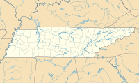
Third Air ForceLocated Near: Halls, Tennessee 
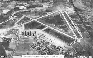
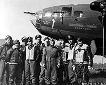
Dyersburg Army Air Base - 3 November 1943Coordinates 35°54′12″N 089°23′50″W / 35.90333°N 89.39722°W Built by United States Air Force In use 1942-1945 Battles/wars World War II  Crew of the Memphis Belle
- For the civilian airport use, see Arnold Field (Tennessee)
Dyersburg Army Air Base is an inactive United States Air Force base, approximately 2 miles north of Halls, Tennessee. It was active during World War II as a training airfield. It was closed on 30 November 1945
Dyersburg AAB was the largest combat aircrew training school built during the early war years. It was the only inland B-17 Flying Fortress training base east of the Mississippi River. The base was located on 2,541 acres (10.28 km2), not including the practice range. Approximately 7,700 crew men received their last phase training at DAAB. 114 crew men lost their lives.
Contents
History
Origins
The Dyersburg Army Air Base (DAAB), promoted by Congressman Jere Cooper and solicited by local officials of Dyersburg in 1941, was actually located near the edge of Halls, Tennessee since an Army study indicated that the Lauderdale County site was better suited for the base.
The origins of Dyersburg Army Air Base begin in early 1942 when the War Department because interested in building an air base in the Halls, Tennessee area. Tennessee congressmen encouraged the Air Corps, and an article in the local newspaper at the end of March noted the visits by Army survey teams to the area. Further reports by the paper were noted throughout the spring of 1942 and on 13 April, the first offers for land purchaces were opened and office space for Army officials was leased in Halls for engineering space. Approximately 2,400 acres of land was leased by the War Department and turned over to the Air Corps at the present Arnold Field, this included the relocation of over 70 families from their traditional homesteads. Grading of the land began in late May.[1]
Dyersburg Army Air Base officially became active with the activation of the 910th Quartermaster Company Aviation (Service), on 26 August 1942, however the base was far from ready for operational service. Other early units assigned with the 908th Guard Squadron on 19 October and the 373d Sub-depot on 1 October.
Construction of the base began in earnest in September when runway construction began, as well as the building of a large support base with barracks, various administrative buildings, maintenance shops and hangars. The station facility consisted of a large number of buildings based on standardized plans and architectural drawings, with the buildings designed to be the "cheapest, temporary character with structural stability only sufficient to meet the needs of the service which the structure is intended to fulfill during the period of its contemplated war use" was underway. To conserve critical materials, most facilities were constructed of wood, concrete, brick, gypsum board and concrete asbestos. Metal was sparsely used. The station was designed to be nearly self-sufficient, with not only hangars, but barracks, warehouses, hospitals, dental clinics, dining halls, and maintenance shops were needed. There were libraries, social clubs for officers, and enlisted men, and stores to buy living necessities.
Three long 6,167' runways were constructed in a triangle configuration, oriented N/S, NE/SW and SW/NE. An extra-large parking ramp was constructed for the four-engine bombers along with numerous taxiways and navigational aids. Construction continued through the fall and winter of 1942 and 1943, and by the summer of 1943 the station consisted of over 300 buildings of various configurations and uses. In effect, a city was built on what was a year earlier cotton fields.
Although barracks were moved from other sites and many built for the soldiers, very little housing was available for families. Citizens in Brownsville, Ripley, Halls and Dyersburg made room for the influx of wives, mothers and children who wanted to spend a short time with their soldiers before they went to combat. Attics, garages, and closets were transformed into sleeping areas. Vice-President Harry Truman visited the base during the war as did country singer Roy Acuff and Governor Jim McCord.[1]
Heavy Bomber Training
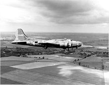
Dysersburg AAB was placed under the Army Air Forces II Bomber Command on 1 February 1943, and the 346th Bombardment Group was assigned to the field on 26 February with four training squadrons. The 502d and 505th Bombardment squadrons provided B-24 Liberator training, while the 503d and 504th Bombardment squadrons provided B-17 Flying Fortress combat crew training.
Training conducted at the field were second and third phases of combat crew training. These phases of training were designed to train flight crew members of the heavy bombers to blend their individual skills together into a team. Second phase training was focused on bombing, gunnery and flying the aircraft under instrument flight conditions. These training missions were flown with full crews. Third phase training emphasized squadron and group operations, especially with formation flying in the combat "box" which was developed by Eighth Air Force to maximize the firepower of the bomber aircraft while also maximizing its defenses against attacking enemy fighters. Also long distance navigation, target identification was taught along with mock combat runs over targets.
Ground synthetic training devices, such as the Celestial Navigation Tower were also used. This device simulated flying conditions in any weather, day or night and taught instrument flying, radio navigation and also flying by stars at night. Another training device was called the "ditching pond" which taught heavy bomber pilots how to perform controlled water landings.
To help acclimate the combat crews soon to be deployed to Eighth Air Force, some streets and buildings on the base were renamed with English names of bases in the United Kingdom. Dyersburg AAF was unofficially called "Peterborough Airdrome" after a simulated station in England.
In June 1943, the 451st Bombardment Group arrived at Dyersburg, the only operational group to be trained as a unit at the base. It's 724th, 725th, 726th and 727th Bombardment Squadrons underwent second and third phase training with the group's B-17s at the base separately from the 346th, with B-24 Liberators before leaving for Wendover Field, Utah in July before deploying to Twelfth Air Force in North Africa during November.
On 1 May 1944, the 346th Bombardment Group was inactivated as part of an overall reorganization of training. Dyersburg assumed responsibility for all three phases of heavy bomber training, phase one training added night flying and long distance flying training for navigators. Bombadier training and gunnery training was also added. The 346th was re-designated the 223d Combat Crew Training School, Army Air Field, Dyersburg, Tennessee. The four training squadrons were redesignated as squadron "A", "B", "C" and "D". In December 1944, P-63 Kingcobra fighters were assigned to the school to help train flexible gunners in fighter defense.
1 March 1945 saw the transfer of Dyersburg AAB jurisdiction from Second Air Force to Third Air Force, as the mission of Second Air Force became the training of B-29 Superfortress crews and replacement personnel. The 223d CCTS was re designated to the 330th. There was also a decline in the training hours from three 5 hour periods each day to two, six days a week. Third Air Force, whose primary focus was fighter pilot training, also assigned additional fighter aircraft types to the filed, including P-40 Warhawks and later, with P-51 Mustangs. Several different types of fighters, with different flying uncharacteristics increased the reality of training for student gunners.
Closure
With the end of the war in Europe in May 1945, Dyersburg AAB was out of a job. The B-29 Superfortress was the strategic bomber used in the Pacific, and replacement heavy bomber crews were no longer needed. Those B-24 Liberator squadrons still operating in India and Burma, along with the B-24s used by Fifth and Seventh Air Forces in the Pacific could be supported by a limited number of trainees at Dyersburg (Note: B-17s were withdrawn from the Pacific in 1943 to support the European Theater, and never used to any great degree in the CBI). Training was drastically curtailed, and was completely stopped by the end of August with the Japanese surrender.
To quote Lt. Colonel Robert Little (Ret.), "Our job was to give about one hundred more hours of flying — we would give them instrument flying, a lot of take offs and landings, some formations, and a little bit of navigation — to men coming from camps like Roswell, New Mexico, and a transition school for B-17s."[2]
On 1 September 1945 Dyersburg AAF was placed on standby status by Third Air Force. Despite a flurry of activity by Congressmen representing Tennessee, the facility was closing, as most temporary training airfields in the United States were. Demobilization was the word of the day.
In 1946, with World War II over, the DAAB was deactivated, and the base was hastily dismantled, land was sold, and barracks and guard shacks were moved to private property. The former morgue was moved and became a two bedroom residence later occupied by a mayor of Halls. The Army left as quickly as it arrived.
Dyersburg today
When the base closed it was converted to civilian uses. The airfield became "Arnold Field Airport", and over the years, the hundreds of buildings of the support station located to the southwest of the airfield were sold, removed or torn down. Today, the only evidence of the containment area are a Norden bombsight storage building, tall chimneys where the theatre and other sites were located, and the large aircraft parking 95 acres (0.38 km2) apron. Forlorn of aircraft, the apron now had hundreds of over the road trailers and an open storage yard with a few buildings erected on the concrete. one wartime hangar out of the original five remain. The Veteran's museum, in which a large number of artifacts and other exhibits are on display is in a building on the former aircraft parking apron.
A large agricultural chemical plant was built on the former station area, but much of it was removed with the roads and streets torn up; the land returned to agricultural production, with the street grid of the support station being obliterated.
The former north-south runway is used as the runway for Arnold Field Airport, along with lots of overgrown things apparently dumped on the parallel north-south taxiway of the old military airbase. The other two runways and assorted taxiways of the former airfield remain, abandoned, although they appear in good condition after decades of disuse.
See also
References
 This article incorporates public domain material from websites or documents of the Air Force Historical Research Agency.
- Shaw, Frederick J. (2004), Locating Air Force Base Sites History’s Legacy, Air Force History and Museums Program, United States Air Force, Washington DC, 2004.
- Manning, Thomas A. (2005), History of Air Education and Training Command, 1942–2002. Office of History and Research, Headquarters, AETC, Randolph AFB, Texas ASIN: B000NYX3PC
External links
 USAAF Second Air Force in World War II
Airfields Group Training Stations · Heavy Bombardment Training Stations · Replacement Training Stations · Tactical Airfields · Very Heavy Bomber Bases
Units Commands II Air Support Command · II Bomber Command · II Fighter Command · IV Air Support Command · XX Bomber Command · XXI Bomber Command · XXII Bomber CommandWings 5th Bombardment · 15th Bombardment Training · 16th Bombardment Operational Training · 17th Bombardment Training · 18th Replacement · 21st Bombardment · 46th Bombardment Operational Training · 58th Bombardment · 73d Bombardment · 315th Bombardment · 316th BombardmentGroups Bombardment 2d Bombardment · 6th Bombardment · 7th Bombardment · 9th Bombardment · 12th Bombardment · 16th Bombardment · 17th Bombardment · 19th Bombardment · 25th Bombardment · 29th Bombardment · 34th Bombardment · 39th Bombardment · 40th Bombardment · 42d Bombardment · 46th Bombardment · 47th Bombardment · 48th Bombardment · 85th Bombardment · 86th Bombardment · 86th Bombardment · 88th Bombardment · 94th Bombardment · 95th Bombardment · 96th Bombardment · 99th Bombardment · 100th Bombardment · 301st Bombardment · 302d Bombardment · 303d Bombardment · 304th Bombardment · 305th Bombardment · 306th Bombardment · 307th Bombardment · 308th Bombardment · 312th Bombardment · 330th Bombardment · 331st Bombardment · 333d Bombardment · 346th Bombardment · 351st Bombardment · 376th Bombardment · 379th Bombardment · 381st Bombardment · 382d Bombardment · 383d Bombardment · 384th Bombardment · 385th Bombardment · 388th Bombardment · 390th Bombardment · 393d Bombardment · 395th Bombardment · 396th Bombardment · 398th Bombardment · 399th Bombardment · 400th Bombardment · 401st Bombardment · 407th Bombardment · 415th Bombardment · 418th Bombardment · 444th Bombardment · 445th Bombardment · 446th Bombardment · 447th Bombardment · 448th Bombardment · 449th Bombardment · 450th Bombardment · 451st Bombardment · 452d Bombardment · 453d Bombardment · 454th Bombardment · 455th Bombardment · 456th Bombardment · 457th Bombardment · 458th Bombardment · 459th Bombardment · 460th Bombardment · 461st Bombardment · 462d Bombardment · 464th Bombardment · 467th Bombardment · 468th Bombardment · 469th Bombardment · 470th Bombardment · 471st Bombardment · 472d Bombardment · 484th Bombardment · 485th Bombardment · 486th Bombardment · 487th Bombardment · 488th Bombardment · 489th Bombardment · 490th Bombardment · 491st Bombardment · 493d Bombardment · 494th Bombardment · 497th Bombardment · 498th Bombardment · 499th Bombardment · 500th Bombardment · 501st Bombardment · 502d Bombardment · 504th Bombardment · 505th Bombardment · 509th CompositeFighter Reconnaissance 2d Reconnaissance · 3d Reconnaissance · 4th Reconnaissance · 5th Reconnaissance · 6th Reconnaissance · 7th Reconnaissance · 8th Reconnaissance · 71st Reconnaissance · 77th ReconnaissanceTroop Carrier 443d Troop Carrier USAAF Third Air Force in World War II
Airfields Group Training Stations · Replacement Training Stations · Tactical Airfields
Units Commands II Air Support Command · III Air Support Command · III Bomber Command · III Fighter Command · III Reconnaissance Command · III Tactical Air CommandDivisions III Tactical Air DivisionWings 8th Fighter Wing · 9th Fighter Wing · 40th Bombardment WingGroups Air Commando 2nd Air Commando · 3rd Air CommandoBombardment 3rd Bombardment · 12th Bombardment · 17th Bombardment · 21st Bombardment · 29th Bombardment · 30th Bombardment Group · 38th Bombardment · 44th Bombardment · 46th Bombardment · 47th Bombardment · 85th Bombardment · 88th Bombardment · 90th Bombardment · 91st Bombardment · 92nd Bombardment · 93rd Bombardment · 94th Bombardment · 95th Bombardment · 97th Bombardment · 98th Bombardment · 99th Bombardment · 100th Bombardment · 309th Bombardment · 310th Bombardment · 312th Bombardment · 319th Bombardment · 320th Bombardment · 321st Bombardment · 322d Bombardment · 323d Bombardment · 335th Bombardment · 336th Bombardment · 340th Bombardment · 344th Bombardment · 345th Bombardment · 386th Bombardment · 387th Bombardment · 391st Bombardment · 394th Bombardment · 396th Bombardment · 397th Bombardment · 409th Bombardment · 410th Bombardment · 411th Bombardment · 416th Bombardment · 417th Bombardment · 418th Bombardment · 451st Bombardment · 454th Bombardment · 463rd Bombardment · 483rd Bombardment · 488th BombardmentFighter 20th Fighter · 31st Fighter · 49th Fighter · 50th Fighter · 53rd Fighter · 54th Fighter · 56th Fighter · 59th Fighter · 79th Fighter · 80th Fighter · 81st Fighter · 84th Fighter · 85th Fighter · 311th Fighter · 332nd Fighter · 337th Fighter · 338th Fighter · 339th Fighter · 361st Fighter · 369th Fighter · 372nd Fighter · 404th Fighter · 405th Fighter · 408th Fighter · 414th Fighter · 506th FighterFighter-Bomber 27th Fighter-Bomber · 48th Fighter-Bomber · 86th Fighter-Bomber · 406th Fighter-Bomber · 407th Fighter-BomberReconnaissance 2d Reconnaissance · 9th Reconnaissance · 10th Reconnaissance · 26th Reconnaissance · 65th Reconnaissance · 67th Reconnaissance · 68th Reconnaissance · 69th Reconnaissance · 70th Reconnaissance · 75th Reconnaissance · 77th Reconnaissance · 423d Reconnaissance · 424th Reconnaissance · 426th ReconnaissanceCategories:- 1942 establishments
- USAAF Second Air Force Heavy Bombardment Training Stations
- USAAF Second Air Force Replacement Training Stations
- United States Army airfields
- USAAF Third Air Force Tactical Airfields
- USAAF Third Air Force Group Training Stations
- USAAF Third Air Force Replacement Training Stations
- Airfields of the United States Army Air Forces in Tennessee
Wikimedia Foundation. 2010.


