- Blue Line (UTA Trax)
-

Blue Line
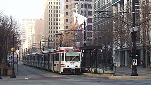
Train on the Blue Line at the Gallivan Plaza stop
in Downtown Salt Lake City headed towards SandyOverview Type Light rail System UTA Trax Status operating Locale Wasatch Front Termini Salt Lake City Intermodal Hub
Sandy Civic CenterStations 21 Operation Opened December 4, 1999 Operator(s) Utah Transit Authority Rolling stock Typical: Siemens SD-100 and SD160 vehicles[1] Technical Line length Original (1999): 15 mi (24 km)[2]
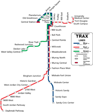
Current (2009): 16 mi (26 km)[3]No. of tracks 2 Track gauge 1,435 mm (4 ft 8 1⁄2 in) Standard gauge Electrification Overhead catenary Operating speed Maximum: 55 mph (89 km/h)[4] Route map The Blue Line is a line in the Trax light rail system in the Salt Lake City area, operated by the Utah Transit Authority (UTA). It is the first line in the Trax system; the line opened on December 4, 1999, one year ahead of schedule after two years of construction. In addition to Salt Lake City, it also serves the communities of South Salt Lake, Murray, Midvale, and Sandy. The line was known as the North/South Line or the Sandy/Salt Lake Line until color names were adopted for each Trax line in August 2011.
Contents
Route
Starting from the Sandy Civic Center station in Sandy, Utah, the Blue Line heads north, passing Jordan High School as it comes to an infill station, Sandy Expo,[5] serving Rio Tinto Stadium. After crossing Utah State Route 209 (SR-209, 9000 South) the Historic Sandy island platform station is reached, marking the last station in Sandy.
After passing overtop of U.S. Route 89 (US-89, State Street) in Midvale, the Midvale Center station is reached, and quickly followed by the Midvale Fort Union station. A non-revenue side track departs the mainline just south of West Winchester Street and the Fashion Place West station that provides access to the Trax depot. The station also provides a transfer to the Red Line, which opened in August 2011.
I-215 passes underneath as the Union Pacific (UP) tracks expand from two tracks to five tracks, with Trax using the two western tracks, and UP using the eastern three tracks. This expansion is short however, and discontinues just before the Murray Central station in Murray, Utah, which is directly behind the new Intermountain Healthcare hospital. Another siding exists briefly, ending at 4800 South. SR-266 travels underneath Trax as it continues north, stopping at the Murray North station.
Meadowbrook station is the next station and quickly followed by the Millcreek station. I-80 heads into the spaghetti bowl interchange with I-15 just west of Trax as it stops at the only station in South Salt Lake, Central Pointe. Continuing north, access to Spring Mobile Ballpark is provided by the first station in Salt Lake City limits, Ball Park. Just to the northwest of the Ball Park station is a non-revenue track, extending all the way to 400 South. Another in fill station,[5] 900 South is the last station before Trax approaches downtown Salt Lake City.
The mainline continues north in the center median of 200 West, turning east at 700 South for two blocks to Main Street. In the center median of Main Street, just north of the Grand America Hotel and the Little America Hotel, west of the Scott Matheson Courthouse is the first station with in the free fare zone, Courthouse. The line continues north along Main Street, intersecting trackage that carries the Red Line at 400 South. Gallivan Plaza is next, followed by City Center, before the route turns west on South Temple.
Temple Square is the first stop in the median of South Temple, and is just west of Temple Square home to the Salt Lake Temple of the Church of Jesus Christ of Latter-day Saints. Arena (formerly Delta Center) use to be the terminus of both the Sandy/Salt Lake and the old University Line, however, an expansion opened on April 16, 2008 which provided access to the Salt Lake City Intermodal Hub and the new FrontRunner commuter rail system.[dead link][6] Immediately after the Arena station, the line turns south on 400 West and stops at the Planetarium station, providing access to the Gateway Mall. The route turns west again at 200 South and continues this way to 600 West, stopping at the Old Greek Town station along the way. Trax terminates at the Intermodal hub, along 600 West, between 300 South and 400 South. From August 23, 2009 to October 31, 2009, the terminus was truncated to Arena station.[7]
Stations
Trax Blue Line (Salt Lake–Sandy) Station Name Opening Year Municipality Park and Ride Notes Salt Lake Central Station 2008 Salt Lake City Yes At the Salt Lake City Intermodal Hub. Transfer to FrontRunner and Amtrak. Old GreekTown No Planetarium Serving Clark Planetarium and the Gateway Mall. Arena 1999 Serving Energy Solutions Arena. Temple Square Serving Temple Square. City Center Serving City Creek Center. Gallivan Plaza Serving the Gallivan Plaza. Courthouse Transfer to Red Line. 900 South 2005 Ball Park 1999 Yes Serving Spring Mobile Ballpark. Central Pointe South Salt Lake Transfer to Green Line. Millcreek Transfer to MAX bus rapid transit line. Meadowbrook Murray North Murray Murray Central Serving the Intermountain Medical Center; future transfer to FrontRunner. Fashion Place West Transfer to Red Line. Midvale Fort Union Midvale Midvale Center Historic Sandy Sandy Sandy Expo 2006 Serving South Towne Exposition Center and Rio Tinto Stadium. Sandy Civic Center 1999 Serving South Towne Center and Jordan High School. End of the Line Draper extension
An extension of the Blue Line to Draper is scheduled to open in 2014. Construction on the extension began in 2010 as part of UTA's FrontLines 2015 project, which also includes the West Valley section of the Green Line, the Mid-Jordan extension of the Red Line, and the southern extention of the FrontRunner commuter rail line. The Draper extension will continue south from Sandy Civic Center to Pioneer Road in Draper.
Additional stations Station Opening Year Municipality Park and Ride Notes 11400 South 2014 (planned) Sandy Planned Serving local neighborhoods. 11800 South Draper Serving local neighborhoods and Juan Diego Catholic High School. Draper Town Center Near Draper City Hall and Draper Park. End of the Line See also
References
- ^ "Trax and FrontRunner Fact Sheet". Utah Transit Authority. http://www.rideuta.com/files/UTAfleettraxfrontrunner102208.pdf. Retrieved 2009-07-25.
- ^ Van Eyck, Zack (1999-03-14). "Some bus routes will change when TRAX goes into effect". Deseret News. pp. B4. http://news.google.com/newspapers?id=7L0RAAAAIBAJ&sjid=4ewDAAAAIBAJ&pg=6303,6929828&dq=sandy+trax. Retrieved 2009-07-25.[dead link]
- ^ "Downtown extension of TRAX nearly done". Deseret News. 2007-11-04. http://www.deseretnews.com/article/1,5143,695224646,00.html. Retrieved 2009-07-25.
- ^ Speckman, Stephen (2003-10-05). "Making TRAX on Sandy line". Deseret News. http://findarticles.com/p/articles/mi_qn4188/is_20031005/ai_n11424837/?tag=rel.res4. Retrieved 2009-07-25.
- ^ a b Daley, John (2004-04-12). "Two New Stops Planned for TRAX". KSL.com. http://www.ksl.com/index.php?nid=148&sid=85381. Retrieved 2009-07-25.
- ^ "UTA Announces TRAX Extension Construction Complete". Deseret News. 2008-04-16. http://rideuta.com/mediaRoom/pressReleases.aspx?pressReleaseID=714. Retrieved 2008-04-16.
- ^ Groves, Lana (2009-08-20). "Commuters give UTA changes mixed reviews". Deseret News. http://www.deseretnews.com/article/705324831/Commuters-give-UTA-changes-mixed-reviews.html. Retrieved 2009-08-23.
External links
Utah Transit Authority Current Trax lines Future Trax extensions Former lines Trax stations 900 East · 900 South · 2700 West · 4800 West · 5600 West · Arena · Ball Park · Bingham Junction · Central Pointe · City Center · Courthouse · Daybreak Parkway · Decker Lake · Fashion Place West · Fort Douglas · Gallivan Plaza · Historic Gardner · Historic Sandy · Jordan Valley · Library · Meadowbrook · Midvale Center · Midvale Fort Union · Millcreek · Murray Central · Murray North · Old Greek Town · Planetarium · Redwood Junction · River Trail · Salt Lake Central Station · Sandy Civic Center · Sandy Expo · South Jordan Parkway · Stadium · Temple Square · Trolley · University Medical Center · University South Campus · West Jordan City Center · West Valley Central StationCommuter rail FrontRunner stations Bus rapid transit Other projects Sugar House StreetcarConnecting services Website Categories:- Utah Transit Authority
- Union Pacific Railroad
- Transportation in Salt Lake County, Utah
Wikimedia Foundation. 2010.


