- Don Chedi District
-
Don Chedi
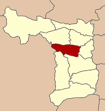
ดอนเจดีย์— Amphoe — Amphoe location in Suphanburi Province
Coordinates: 14°38′06″N 100°01′18″E / 14.635°N 100.02167°ECoordinates: 14°38′06″N 100°01′18″E / 14.635°N 100.02167°E Country  Thailand
Province Suphanburi Seat Don Chedi Tambon Muban Amphoe established Area - Total 252.081 km2 (97.3 sq mi) Population (2005) - Total 45,336 - Density 179.8/km2 (465.7/sq mi) Time zone THA (UTC+7) Postal code 72170 Geocode 7206 Don Chedi (Thai: ดอนเจดีย์; IPA: [dɔ̄ːn tɕēːdīː]) is a district (Amphoe) of Suphanburi Province, Thailand.
Contents
Geography
Neighboring districts are (from the north clockwise) Nong Ya Sai, Sam Chuk, Si Prachan, Mueang Suphanburi and U Thong, and in Kanchanaburi Province the district Lao Khwan.
History
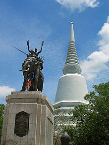 Don Chedi war memorial
Prince Damrong Rajanubhab in 1913 discovered the remains of a large chedi within the district. He identified it as the one built by King Naresuan in 1593 after his win against the Burmese. The chedi was reconstructed in 1952. In 1959 a statue of the king on his war elephant cast by Silpa Bhirasri was added.
However, more recent research casts doubt on this identification. Although one of the chronicles explicitly places the battle at Suphanburi, the others don't give any clear location. The Dutch merchant Jeremias van Vliet, however, wrote in his Short History of the Kings of Siam in 1640 that the battle took place near Ayutthaya - which would make Chedi Phu Khao Thong the likely place of this battle.
The area of the district was originally part of Si Prachan district. It was established as a minor district (King Amphoe) on January 1 1962, consisting of the two tambon Don Chedi and Nong Sarai.[1] It was upgraded to a full district on July 27 1965.[2]
Administration
The district is subdivided into 5 subdistricts (Tambon), which are further subdivided into 48 villages (muban). There are two townships (thesaban tambon) - Don Chedi and Sa Krachom, each covering parts of the same-named tambon. Each of the tambon is administrated by a Tambon administration organization (TAO).
Nr. Name Thai name Villages Inh. 1. Don Chedi ดอนเจดีย์ 9 14,219 2. Nong Sarai หนองสาหร่าย 10 7,897 3. Rai Rot ไร่รถ 9 7,465 4. Sa Krachom สระกระโจม 8 8,514 5. Thale Bok ทะเลบก 12 7,241 References
- ^ "ประกาศกระทรวงมหาดไทย เรื่อง การแบ่งท้องที่ตั้งเป็นกิ่งอำเภอ" (in Thai). Royal Gazette 79 (4 ง): 32–33. January 9 1962. http://www.ratchakitcha.soc.go.th/DATA/PDF/2505/D/004/32.PDF.
- ^ "พระราชกฤษฎีกาตั้งอำเภอศรีสวัสดิ์ อำเภอสังขละบุรี อำเภอท่าคันโท อำเภอดอกคำใต้ อำเภอแม่ใจ อำเภอจุน อำเภอขามทะเลสอ อำเภอไพศาลี อำเภอท่าวังผา อำเภอบ้านกรวด อำเภอเด่นชัย อำเภอปทุมรัตต์ อำเภอกะเปอร์ อำเภออากาศอำนวย อำเภอดอนเจดีย์ อำเภอจอมพระ และอำเภอสามโก้ พ.ศ. ๒๕๐๘" (in Thai). Royal Gazette 81 (49 ก): 565–569. July 27 1965. http://www.ratchakitcha.soc.go.th/DATA/PDF/2508/A/059/565.PDF.
External links
Amphoe of Suphanburi Categories:- Amphoe of Suphanburi

Wikimedia Foundation. 2010.