- Doem Bang Nang Buat District
-
Doem Bang Nang Buat
เดิมบางนางบวช— Amphoe — Amphoe location in Suphanburi Province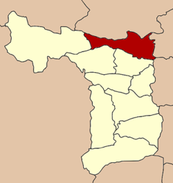
Coordinates: 14°51′13″N 100°5′52″E / 14.85361°N 100.09778°ECoordinates: 14°51′13″N 100°5′52″E / 14.85361°N 100.09778°E Country  Thailand
Province Suphanburi Seat Khao Phra Tambon Muban Amphoe established Area - Total 552.3 km2 (213.2 sq mi) Population (2005) - Total 74,619 - Density 135.1/km2 (349.9/sq mi) Time zone THA (UTC+7) Postal code 72120 Geocode 7202 Doem Bang Nang Buat (Thai: เดิมบางนางบวช; IPA: [dɤ̄ːm bāːŋ nāːŋ bùat]) is a district (Amphoe) in the northern part of Suphanburi Province, central Thailand.
Contents
History
In the past, Nang Buat district covered a large area. Prince Damrong Rajanubhab and the governor of Suphanburi agreed to separate the northernmost part and then created a new district named Doem Bang on May 16, 1911. They also added two tambons of Hankha district, Chainat Province and two tambons of Bang Rachan district, Sing Buri Province.[1] In 1939 the government changed the district name of Nang Buat district to Sam Chuk, they decided to put the word Nang Buat after Doem Bang, so since that year the district is named Doem Bang Nang Buat.[2]
The present district office is located on Chainat-Suphanburi Road, Tambon Khao Phra since 1995.
Geography
Neighboring districts are (from the north clockwise) Noen Kham, Hankha and Sankhaburi of Chainat Province, Bang Rachan and Khai Bang Rachan of Sing Buri Province, Sawaeng Ha of Ang Thong Province, and Sam Chuk, Nong Ya Sai and Dan Chang of Suphanburi Province.
The main water resource of Doem Bang Nang Buat is the Tha Chin river or Suphan river.
Administration
The district is subdivided into 14 subdistricts (tambon). There are three townships (thesaban tambon) within the district - Khao Phra covers parts of the tambon Khao Phra and Doem Bang, Nangbuat covers parts of tambon Nangbuat, and Bo Kru covers parts of tambon Bo Kru.
No. Name Thai Inh. 1. Khao Phra เขาพระ 8,823 2. Doem Bang เดิมบาง 7,692 3. Nang Buat นางบวช 8,027 4. Khao Din เขาดิน 5,950 5. Pak Nam ปากน้ำ 4,859 6. Thung Khli ทุ่งคลี 5,644 7. Khok Chang โคกช้าง 4,566 8. Hua Khao หัวเขา 6,932 9. Hua Na หัวนา 4,523 10. Bo Kru บ่อกรุ 4,331 11. Wang Si Rat วังศรีราช 646 12. Pa Sakae ป่าสะแก 2,944 13. Yang Non ยางนอน 4,741 14. Nong Krathum หนองกระทุ่ม 4,941 References
- ^ "ประกาศกระทรวงมหาดไทย ประกาศตั้งอำเภอเดิมบางและเปลี่ยนชื่ออำเภอเดิมบางเก่าเป็นอำเภอบ้านเชียน" (in Thai). Royal Gazette 28 (0 ง): 299–300. May 21 1911. http://www.ratchakitcha.soc.go.th/DATA/PDF/2454/D/299.PDF.
- ^ "พระราชกฤษฎีกาเปลี่ยนนามอำเภอ กิ่งอำเภอ และตำบลบางแห่ง พุทธศักราช ๒๔๘๒" (in Thai). Royal Gazette 56 (0 ก): 354–364. April 17 1939. http://www.ratchakitcha.soc.go.th/DATA/PDF/2482/A/354.PDF.
External links
Amphoe of Suphanburi Categories:- Amphoe of Suphanburi
- Central Thailand geography stubs

Wikimedia Foundation. 2010.