- Orange Walk District
-
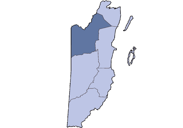
Orange Walk District — District — Location of the district in Belize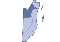
Country  Belize
Capital Orange Walk Town Population (2009)[1] - Total 49,500 Orange Walk District is a district in the northwest of the nation of Belize, with its district capital in Orange Walk Town.
Contents
Main settlements
The Orange Walk District, with an area of 1829 square miles (4,636 square km), is located north-northeast of the Belize District. This is the second largest district in terms of total area and lies between the Belize and Corozal districts to the east, Mexico to the north and Guatemala to the west. Significant villages in Orange Walk District include August Pine Ridge, Blue Creek, Carmelita, Chan Pine Ridge, Douglas, Indian Church, Guinea Grass, San Antonio, San Carlos, San Estevan, San Felipe, San José, San Jose Palmar, Nuevo San Juan, San Lazaro, San Luis, San Pablo, San Roman, Santa Cruz, Santa Martha, Shipyard, Trial Farm, Trinidad and Yo Creek. Other settlements with smaller numbers of inhabitants may also be found, as well as ancient Mayan sites such as Cuello, Lamanai, Noh Mul and Chan Chich. The Rio Bravo Conservation and Management Area, a large private nature reserve in the Yalbac Hills, is also located in this district. The land is highly cultivated with sugar cane, sorghum, rice, corn and vegetables by Mennonite farmers.
At the 2007 mid-year census,[2] the Orange Walk District had an estimated population of 47,145 people. Orange walk is also known to be one of the most common north districts to have access to contraband when it comes to most known places in Santa Cruz village; Where is the known Place called Botes which is a part of Mexico. The other well known place is found in the blue Creek area named la Union. Many people who strive to stretch there dollar visit those places and buy there goods and needs for their families. Orange Walk is a District where you will find mostly Mestizo Hispanic people. Orange Walk also has different tourist attraction such as Lamanai and Cuellos site.Lamanai is found in the Indian Church Village; where the site has three enormous ruins that bring about the past of our ancestors it also has articrafts on display.
Economy
The capital of the district is Orange Walk Town, with an estimated population of 15,990 ([1]). The district is home to mostly Maya mestizo descendants of Mexican refugees who fled from the 1840 Caste War. The district's main economic base is drawn from agriculture, with sugar cane being the primary crop. This is slowly being replaced by a combination of alternative crops such potatoes, onions and soya beans. Orange Walk is also important for its production of dairy products, citrus fruits, beef and rum production. Another emerging industry is tourism due to healthy populations of tropical wildlife and the rich archaeological sites now coming to light. There are over 400 recorded bird species in the district, making Orange Walk a birdwatcher's paradise. Several settlements in the district are also home to German speaking Amish Mennonites, creole, and maya ketchi. The district is also the home of two rivers, the Rio Hondo, which also forms part of the border with Mexico, and the New River. In this district you can also find Belize's largest body of water, the New River Lagoon.
The economy in Orange Walk consist of mostly agriculture people based their lives and income on the sugar cane industry. The Belize Sugar Industry provides many employment for the people thus helping the economy to be a good one. But it is also in concern that if anything happens to the industry then there will be many losses when it comes to economic growth because the industry also benefits the country of Belize when the sugar is exported.
History
Orange Walk District was previously dominated by loggers for over a hundred years until the refugees of the Caste War arrived in the late 19th century. At the time of logging, all the timber was floated down the New River into the Corozal Bay, then to Belize City and shipped abroad. Similar to the Corozal District, at the time of the arrival of the refugees, the logging industry was in decline and eventually gave rise to the sugar industry.
Although the Orange Walk District has no coast because it is locked inland, it boasts the remains of two forts, Mundy and Cairns, that were the scene of battles between earlier Mayan inhabitants of the district and settlers. ([2])
Political divisions
Politically, Orange Walk is divided into 4 constituencies, three currently under the ruling United Democratic Party (UDP) and one under the People's United Party PUP.
Orange Walk Central
Orange Walk Central generally includes the vicinity of Orange Walk Town and the village of San Estevan. Since 1993, this seat has been held by the PUP's John Briceno, formerly a Deputy Prime Minister. Briceno was reelected in the 2008 elections. This area is a stronghold of the opposition party.
Orange Walk East
Orange Walk East includes the eastern area of Orange Walk Town and the easternmost villages in the district, particularly San Jose Palmar, Chan Pine Ridge, Tower Hill, Carmelita and Santa Martha. Marcel Cardona won this seat for the UDP in the 2008 elections. This constituency was previously held from 1998 to 2008 by Dave Burgos; two consecutive terms.
Orange Walk North
Gaspar Vega won this seat for the UDP in the 2008 elections. The area includes the Otro Benque area of Orange Walk Town and the villages of Trial Farm, San Jose, San Pablo, Douglas, San Roman, San Luis, Nuevo San Juan and until recently, San Antonio and Santa Cruz. This seat was formerly held by Servulo Baeza.
Orange Walk South
Orange Walk South contains the villages of San Lazaro, Yo Creek, Trinidad, August Pine Ridge, San Felipe, Guinea Grass, Blue Creek, Shipyard and a number of other villages.Marco Pech is the recently elected area representative. This area has traditionally been PUP and the seat was held by Ismael Cal from 2003-2008.
References
External links
Belize | Cayo | Corozal | Orange Walk | Stann Creek | Toledo
 Categories:
Wikimedia Foundation. 2010.