- Corozal District
-
Corozal District — District — Location of the district in Belize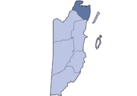
Country  Belize
Capital Corozal Town Population (2009)[1] – Total 37,300
Corozal District is the northernmost district of the nation of Belize. The population was 33,335 as of 2000. The district capital is Corozal Town.Contents
The Villages of Corozal District
Corozal District includes the villages of Buena Vista, Calcutta, Caledonia, Carolina, Chan Chen, Chunox, Concepcion, Consejo, Copper Bank, Corozal Town is not a village in the Corozal District, Cristo Rey, Estrella, Libertad, Little Belize, Louisville,Paraiso, Patchakan, Progresso, Ranchito, San Andres, San Antonio, San Joaquin, San Narciso, San Roman, San Victor, Santa Clara, Sarteneja, Xaibe, and Yo Chen.
The island of Ambergris Caye is geographically close to Corozal District, but it is a part of Belize District.
Pre-Columbian Maya ruins are found in Corozal at Santa Rita near Corozal Town,and at Cerros.
Political Divisions
There are four political divisions in the Corozal District and they are all being represented by members of the ruling United Democratic Party, except for one.
Corozal Bay was previously held by Vildo Marin, but in 2008 Pablo Marin won the seat under the UDP banner and is the representative for the area until the next general election. Pablo Marin is a relative of Vildo Marin. The current Mayor of Corozal Town is Hilberto Campos, also a member of the United Democratic Party. Corozal South East continues to be a PUP stronghold and the strong man in that constituency was Florencio Marin Sr. who in 2008 relinquished the seat to his son Florencio Marin Jr. Marin currently represents that area.
Gabriel Martinez won the 2008 elections in Corozal South West.
In Corozal North Valdemar Castillo was defeated by Nemencio Acosta of the UDP party.
Economy
While Corozal District depended for many years on the sugar industry, at one time having its own sugar factory located in Libertad Village, today the economy is more diversified. Sugar production and other agricultural crops such as papaya are still central to the way of life of many rural Corozalenos, but occupations in the tourism industry are slowly becoming more prominent. Now almost 65% of Corozalenos depend on the Commercial Free Zone for employment. The Zone is located on the border of Belize and Mexico.
Contraband is the most biggest source of gaining income in Corozal since it is located near the Mexican side. Supplies such as vegetables,fruits,liquors,cigarettes and gasoline
Languages
Spanish is the most spoken language in Corozal, followed by English. 80% speak Spanish very well and 60% speak English very well.
Corozal's villages are divided by color and language:
Corozal Town, the main center of the District, is peopled by a mix of Belize's races and cultures, most notably the Mestizos. Spanish and English are the major languages spoken.
Calcutta, Estrella Village, Libertad, Ranchito, and San Antonio are populated by East Indian people and speak English and Spanish very well.
Chan Chen, Chunox, Cristo Rey, Louisville, Patchakan, San Pedro, San Victor Village, Xaibe, and Yo Chen are populated by Hispanic people and speak Spanish and the Yucatán Mayan language very well, along with some English.
Buena Vista, Caledonia, Conception, San Narciso, San Roman, and Santa Clara are populated by Hispanic people who speak Spanish and some English. They are not obliged to learn English, because school teachers teach in Spanish but write in English and because at work the primary language is Spanish, so villagers are not exposed to English on a daily basis.
Progresso, San Andres, and Sarteneja Village are populated by Creole and Hispanic people, who share their cultures and languages in English and Spanish.
Little Belize is populated by Mennonites, who speak German.
Education
Corozal Community College and Corozal Junior College are found in the village of San Andres and also near San Antonio in Corozal District.
St. Viator Vocational High School is located just outside Chunox in the Corozal District.
Escuela Secundaria Tecnica Mexico or ESTM is located in the village of Santa Narciso in the Corozal District.
References
- ^ "Mid‐Year Population by District and Sex, 2009". Statistical Institute of Belize. http://www.statisticsbelize.org.bz/dms20uc/dynamicdata/docs/20100112164405_2.pdf.
External links
Belize | Cayo | Corozal | Orange Walk | Stann Creek | Toledo
 Categories:

Wikimedia Foundation. 2010.