- Diapur, Victoria
-
Diapur
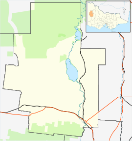
VictoriaPopulation: 20 Postcode: 3418 Coordinates: 36°19′S 141°26′E / 36.317°S 141.433°ECoordinates: 36°19′S 141°26′E / 36.317°S 141.433°E Location: LGA: Shire of Hindmarsh State District: Lowan Federal Division: Mallee Diapur is a locality in western Victoria, in Australia situated about 350km northwest of Melbourne. Diapur is situated on the Melbourne-Adelaide railway line and is the halfway point of the journey. Diapur has an elevation of approximately 160m above sea level.
The nearest more populous place is the town of Nhill which is 18km away with a population of around 2,000 .
Diapur once had a G.J.Coles variety store.
The locality once had a football side, It won a premiership in 1910 and last competed in 1930 in the Lowan Star Football Association.
Towns in the Shire of Hindmarsh Cities and towns in the Wimmera region of Victoria Cities: Ararat · Horsham
Towns/Communities: Antwerp · Apsley · Armstrong · Balmoral · Beulah · Birchip · Brim · Callawadda · Dadswells Bridge · Dimboola · Donald · Douglas · Edenhope · Glenorchy · Goroke · Great Western · Halls Gap · Harrow · Haven · Jeparit · Joel Joel · Lawloit · Kaniva · Marnoo · Minimay · Minyip · Murtoa · Natimuk · Netherby · Nhill · Pimpinio · Pomonal · Rainbow · Rupanyup · Serviceton · St Arnaud · Stawell · Tarraginnie · Telopea Downs · Wallup · Warracknabeal · Wartook · Willenabrina · YaapeetCategories:- Towns in Victoria (Australia)
- Wimmera
- Victoria (Australia) geography stubs
Wikimedia Foundation. 2010.

